Health nearby Riad saliba
Israel
Health nearby Riad saliba
Riad saliba
68, Jabur Yusef Jabur Street, Shefa-'Amr, Akko, IL Israel
contacts phone
:
+972
Latitude:
32.8069538
, Longitude:
35.1684365
larger map & directions
read more
nearest Health
174 m
Moriah's mansion
Shefa-'Amr
Health
read more
195 m
דר חאלד ראמי
Israel
Dentist
Health
Point of interest
Establishment
read more
195 m
דר ג'ריס משיעל
ישוב, Shefar'am
Dentist
Health
Point of interest
Establishment
read more
195 m
אבו סאלח ראוף
ישוב, Shefar'am
Dentist
Health
Point of interest
Establishment
read more
195 m
דר קלוד עזאם
שכ' אלעין, Shefar'am
Dentist
Health
Point of interest
Establishment
read more
195 m
תלחמי מאהר
ישוב, Shefar'am
Dentist
Health
Point of interest
Establishment
read more
281 m
Поликлиника Клалит
שפרעם, דואר, Shefa-'Amr
Health
read more
418 m
מרכז רפואי לאומית שפרעם
רחוב 440/רחוב 317, Shefar'am
Hospital
Health
Point of interest
Establishment
read more
441 m
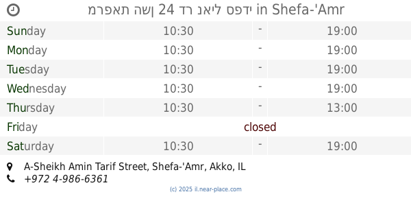
מרפאת השן 24 דר נאיל ספדי
A-Sheikh Amin Tarif Street, Shefa-'Amr
Dentist
Health
Point of interest
Establishment
read more
446 m
קופת חולים לאומית סניף שפרעם
A-Sheikh Amin Tarif Street, Shefa-'Amr
Hospital
Health
Point of interest
Establishment
read more
524 m
קופח מכבי
Shefa-'Amr
Health
read more
612 m
מרכז רפואי מאוחדת שפרעם.
440, מתחת הקונסרבטוריון בית אלמוסיקה, Shefar'am
Hospital
Health
Point of interest
Establishment
read more
748 m
Patients Clalit Fund
Shefa-'Amr
Health
read more
835 m
מרכז יום לקשיש
שפרעם
Health
read more
857 m
דר כאמלה חסנין איוב
شارع حسن نمر،, شفاعمرو،
Dentist
Health
Point of interest
Establishment
read more
📑
all categories
Accounting
Administrative area level 1
Administrative area level 2
Airport
Amusement park
Aquarium
Art gallery
Atm
Bakery
Bank
Bar
Beauty salon
Bicycle store
Book store
Bowling alley
Bus station
Cafe
Campground
Car dealer
Car rental
Car repair
Car wash
Casino
Cemetery
Church
City hall
Clothing store
Colloquial area
Convenience store
Country
Courthouse
Dentist
Department store
Doctor
Electrician
Electronics store
Embassy
Establishment
Finance
Fire station
Florist
Food
Funeral home
Furniture store
Gas station
General contractor
Grocery or supermarket
Gym
Hair care
Hardware store
Health
Hindu Temple
Home goods store
Hospital
Insurance agency
Intersection
Jewelry store
Laundry
Lawyer
Library
Light rail station
Liquor store
Local government office
Locality
Locksmith
Lodging
Meal delivery
Meal takeaway
Mosque
Movie rental
Movie theater
Moving company
Museum
Natural feature
Neighborhood
Night club
Painter
Park
Parking
Pet store
Pharmacy
Physiotherapist
Place of worship
Plumber
Point of interest
Police
Political
Post office
Premise
Real estate agency
Restaurant
Roofing contractor
Route
Rv park, camping
School
Shoe store
Shopping mall
Spa
Stadium
Storage
Store
Subpremise
Subway station
Supermarket
Synagogue
Taxi stand
Train station
Transit station
Travel agency
University
Veterinary care
Zoo
administrative area level 3
administrative area level 4
sublocality level 1
↑