Health nearby קופח מכבי
Coronavirus disease (COVID-19) Situation
confirmed cases
4841772
deaths
12707
Israel
Health nearby קופח מכבי
קופח מכבי
יהוד, ישראל
contacts phone
:
+972 3-539-6222
website:
www.maccabi4u.co.il
Latitude:
32.0276838
, Longitude:
34.8911938
larger map & directions
read more
nearest Health
קופח מכבי
Yehud
Health
read more
162 m
דר שרי יהב בעמ
Derech HaAtsma'ut 40, Yehud
Dentist
Health
Point of interest
Establishment
read more
164 m
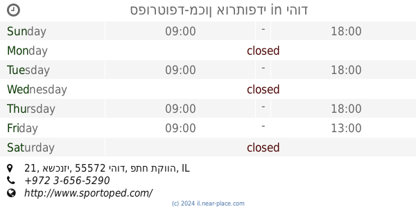
ספורטופד-מכון אורתופדי
אשכנזי 21, יהוד
Health
read more
174 m
Master Fit
Ashkenazi Street 17, Yehud
Health
read more
174 m
Master בכושר
אשכנזי 17, יהוד
Health
read more
174 m
Tali glasses
Ashkenazi Street 17, Yehud
Health
read more
357 m
בית הורים נאות יהוד
יהוד
Health
read more
422 m
Pure Lea
יהודה הלוי 38, יהוד
Health
read more
529 m
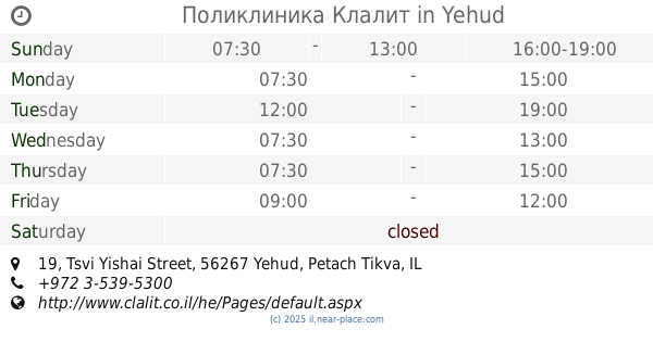
Поликлиника Клалит
Tsvi Yishai Street 19, Yehud
Health
read more
529 m
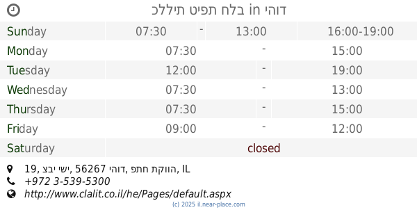
כללית טיפת חלב
צבי ישי 19, יהוד
Health
read more
547 m
דר חנחן ג'ריס וד״ר חנחן נרמין
Tsvi Yishai Street 25, Yehud-Monosson
Dentist
Health
Point of interest
Establishment
read more
549 m
פיזיותרפיה CTT
מוהליבר 1, יהוד
Health
read more
568 m
Patients Clalit Fund
Yehud
Health
read more
575 m
Manpawer care
וייצמן 43, יהוד
Health
read more
600 m
Vicki Glaser
Tidhar Street 29, Ramat Gan
Health
read more
650 m
מרחב אישי
דרך העצמאות 6, יהוד
Health
read more
732 m
דר שלומית מחלב שיבי
Altalef Street
Dentist
Point of interest
Health
Establishment
read more
883 m
נופר קצב קוסמטיקאית פרא רפואית
Se'adya Khatuka Street 69, Yehud
Health
read more
917 m
מרכז שן - צ'י לרפואה שלמה, מרפאת הבית של דוקטור לו צ'אן גואנג ביהוד
טננבאום 14, יהוד
Health
read more
917 m
מרכז שן - צ'י לרפואה שלמה, מרפאת הבית של דוקטור לו צ'אן גואנג ביהוד
Tenenbaum Street 14, Yehud
Health
read more
928 m
מאוחדת סניף יהוד
Herzl Street 24, Yehud
Health
read more
928 m
מאוחדת סניף יהוד
הרצל 24, יהוד
Health
read more
1.048 km
קופח מאוחדת
יהוד
Health
read more
1.06 km
מרכז יום לקשיש
יהוד
Health
read more
1.083 km
איריס טרוינר, מטפלת באומנות
יהוד, HaEgoz 8, Yehud
Health
read more
📑
all categories
Accounting
Administrative area level 1
Administrative area level 2
Airport
Amusement park
Aquarium
Art gallery
Atm
Bakery
Bank
Bar
Beauty salon
Bicycle store
Book store
Bowling alley
Bus station
Cafe
Campground
Car dealer
Car rental
Car repair
Car wash
Casino
Cemetery
Church
City hall
Clothing store
Colloquial area
Convenience store
Country
Courthouse
Dentist
Department store
Doctor
Electrician
Electronics store
Embassy
Establishment
Finance
Fire station
Florist
Food
Funeral home
Furniture store
Gas station
General contractor
Grocery or supermarket
Gym
Hair care
Hardware store
Health
Hindu Temple
Home goods store
Hospital
Insurance agency
Intersection
Jewelry store
Laundry
Lawyer
Library
Light rail station
Liquor store
Local government office
Locality
Locksmith
Lodging
Meal delivery
Meal takeaway
Mosque
Movie rental
Movie theater
Moving company
Museum
Natural feature
Neighborhood
Night club
Painter
Park
Parking
Pet store
Pharmacy
Physiotherapist
Place of worship
Plumber
Point of interest
Police
Political
Post office
Premise
Real estate agency
Restaurant
Roofing contractor
Route
Rv park, camping
School
Shoe store
Shopping mall
Spa
Stadium
Storage
Store
Subpremise
Subway station
Supermarket
Synagogue
Taxi stand
Train station
Transit station
Travel agency
University
Veterinary care
Zoo
administrative area level 3
administrative area level 4
sublocality level 1
↑