Health nearby קופח לאומית
Israel
Health nearby קופח לאומית
קופח לאומית
רמת גן, ישראל
contacts phone
:
+972
Latitude:
32.0711963
, Longitude:
34.8238057
larger map & directions
read more
nearest Health
125 m
מרפאת דר גנדלמן
Uzi'el Street 76, Ramat Gan
Dentist
Health
Point of interest
Establishment
read more
305 m
СТОМАТОЛОГІЧНА ДОПОМОГА. ШВИДКА ТА НЕВІДКЛАДНА СТОМАТОЛОГІЧНА ДОПОМОГА . РАМАТ ГАН
Salk Street 9/3, Ramat Gan
Dentist
Health
Point of interest
Establishment
read more
514 m
דר אלינה סגל
Tirzah Street 19, Ramat Gan
Dentist
Health
Point of interest
Establishment
read more
549 m
מעבדת שיניים אורל אסתטיק
David Ben Gurion Road 197, Ramat Gan
Dentist
Health
Point of interest
Establishment
read more
645 m
בית צבר
Rimalt Street, Ramat Gan
Hospital
Health
Point of interest
Establishment
read more
648 m
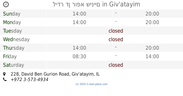
לידר דן רופא שיניים
David Ben Gurion Road 228, Giv'atayim
Dentist
Health
Point of interest
Establishment
read more
843 m
איזי דנט
Kareski Street 9, Ramat Gan
Dentist
Health
Point of interest
Establishment
read more
894 m
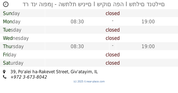
דר דני הופמן - השתלת שיניים I שיקום הפה I שתלים דנטליים
Po'alei ha-Rakevet Street 39, Giv'atayim
Dentist
Health
Point of interest
Establishment
read more
972 m
Dr. Eini - Ramat Gan Clinic
Sderot HaRav Levin 9, Ramat Gan
Dentist
Doctor
Health
Point of interest
Establishment
read more
1.059 km
דר גלית מטצקי
Sirkin Street, Giv'atayim
Dentist
Health
Point of interest
Establishment
read more
1.068 km
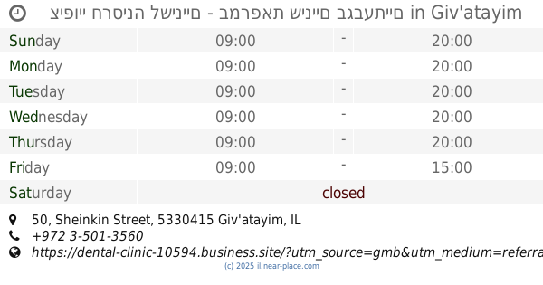
ציפויי חרסינה לשיניים - במרפאת שיניים בגבעתיים
Sheinkin Street 50, Giv'atayim
Dentist
Health
Point of interest
Establishment
read more
1.069 km
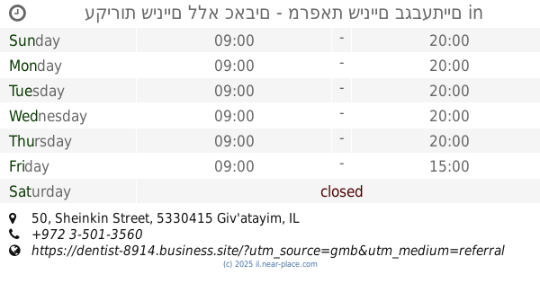
עקירות שיניים ללא כאבים - מרפאת שיניים בגבעתיים
Sheinkin Street 50, Giv'atayim
Dentist
Health
Point of interest
Establishment
read more
1.159 km
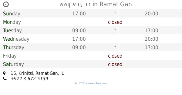
ששון אבי, דר
Krinitsi 16, Ramat Gan
Dentist
Health
Point of interest
Establishment
read more
1.172 km
קופח מכבי
Krinitsi Street 8, Ramat Gan
Dentist
Health
Point of interest
Establishment
read more
1.26 km
אור השן
Bialik Street 10, Ramat Gan
Dentist
Health
Point of interest
Establishment
read more
📑
all categories
Accounting
Administrative area level 1
Administrative area level 2
Airport
Amusement park
Aquarium
Art gallery
Atm
Bakery
Bank
Bar
Beauty salon
Bicycle store
Book store
Bowling alley
Bus station
Cafe
Campground
Car dealer
Car rental
Car repair
Car wash
Casino
Cemetery
Church
City hall
Clothing store
Colloquial area
Convenience store
Country
Courthouse
Dentist
Department store
Doctor
Electrician
Electronics store
Embassy
Establishment
Finance
Fire station
Florist
Food
Funeral home
Furniture store
Gas station
General contractor
Grocery or supermarket
Gym
Hair care
Hardware store
Health
Hindu Temple
Home goods store
Hospital
Insurance agency
Intersection
Jewelry store
Laundry
Lawyer
Library
Light rail station
Liquor store
Local government office
Locality
Locksmith
Lodging
Meal delivery
Meal takeaway
Mosque
Movie rental
Movie theater
Moving company
Museum
Natural feature
Neighborhood
Night club
Painter
Park
Parking
Pet store
Pharmacy
Physiotherapist
Place of worship
Plumber
Point of interest
Police
Political
Post office
Premise
Real estate agency
Restaurant
Roofing contractor
Route
Rv park, camping
School
Shoe store
Shopping mall
Spa
Stadium
Storage
Store
Subpremise
Subway station
Supermarket
Synagogue
Taxi stand
Train station
Transit station
Travel agency
University
Veterinary care
Zoo
administrative area level 3
administrative area level 4
sublocality level 1
↑