Health nearby מאוחדת כפר גנים
Israel
Health nearby מאוחדת כפר גנים
מאוחדת כפר גנים
Petah Tikva, Israel
contacts phone
:
+972 3-729-9500
Latitude:
32.0749642
, Longitude:
34.8733675
larger map & directions
read more
nearest Health
242 m
טופ לייזר
Aharon Meskin Street 30/א, Petah Tikva
Hospital
Health
Point of interest
Establishment
read more
515 m
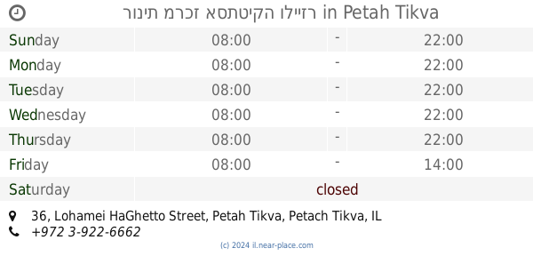
רונית מרכז אסתטיקה ולייזר
Lohamei HaGhetto Street 36, Petah Tikva
Hair care
Hospital
Beauty salon
Doctor
Health
Point of interest
Establishment
read more
640 m
Hanny Ortophedic
Yatkovski Achim Street 6, Petah Tikva
Hospital
Health
Point of interest
Establishment
read more
832 m
כללית
לוי אשכול 4, פתח תקווה
Health
read more
832 m
כללית
Levi Eshkol Street 4, Petah Tikva
Health
read more
1.044 km
מתחילים מחדש
Kaplan Street 40, Petah Tikva
Hospital
Doctor
Health
Point of interest
Establishment
read more
1.067 km
מעבר להילה-הילה גוילי
ישראל עידוד 5, פתח תקווה
Health
read more
1.244 km
Clalit Health Services
Rothschild Street 119, Petah Tikva
Hospital
Health
Point of interest
Establishment
read more
1.25 km
מועדון הג'ודו של פסגת אונו והסביבה
Yitskhak Rabin Street 11, Kiryat Ono
Health
read more
1.265 km
שרון גור - טיפול זוגי ומשפחתי, ליווי זוגות בתהליכי גירושין
דרך רפאל איתן 1, קרית אונו
Health
read more
1.265 km
Sharon Gur - couple and family therapy, support the process of divorcing couples
דרך רפאל איתן 1, Kiryat Ono
Health
read more
1.278 km
ד"ר טיילור ירון
אופק מדיקל , רפאל איתן 1 , קרית אונו קרית אונו
Health
read more
1.278 km
ד"ר ראובן רוזנברג, כירופרקט ותזונאי מוסמך
דרך רפאל איתן 1, קרית אונו
Health
read more
1.278 km
ד"ר ראובן רוזנברג, כירופרקט ותזונאי מוסמך
Derekh Refa'el Eitan 1, Kiryat Ono
Health
read more
1.371 km
Galit Aviv - dental professional guidance
Yitskhak Rabin Street 4, Kiryat Ono
Health
read more
📑
all categories
Accounting
Administrative area level 1
Administrative area level 2
Airport
Amusement park
Aquarium
Art gallery
Atm
Bakery
Bank
Bar
Beauty salon
Bicycle store
Book store
Bowling alley
Bus station
Cafe
Campground
Car dealer
Car rental
Car repair
Car wash
Casino
Cemetery
Church
City hall
Clothing store
Colloquial area
Convenience store
Country
Courthouse
Dentist
Department store
Doctor
Electrician
Electronics store
Embassy
Establishment
Finance
Fire station
Florist
Food
Funeral home
Furniture store
Gas station
General contractor
Grocery or supermarket
Gym
Hair care
Hardware store
Health
Hindu Temple
Home goods store
Hospital
Insurance agency
Intersection
Jewelry store
Laundry
Lawyer
Library
Light rail station
Liquor store
Local government office
Locality
Locksmith
Lodging
Meal delivery
Meal takeaway
Mosque
Movie rental
Movie theater
Moving company
Museum
Natural feature
Neighborhood
Night club
Painter
Park
Parking
Pet store
Pharmacy
Physiotherapist
Place of worship
Plumber
Point of interest
Police
Political
Post office
Premise
Real estate agency
Restaurant
Roofing contractor
Route
Rv park, camping
School
Shoe store
Shopping mall
Spa
Stadium
Storage
Store
Subpremise
Subway station
Supermarket
Synagogue
Taxi stand
Train station
Transit station
Travel agency
University
Veterinary care
Zoo
administrative area level 3
administrative area level 4
sublocality level 1
↑