Health nearby Martyrs of Jabalia clinic
Israel
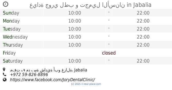
Health nearby Martyrs of Jabalia clinic
Martyrs of Jabalia clinic
Jabalia
contacts phone
:
+972
Latitude:
31.5325877
, Longitude:
34.4866053
larger map & directions
read more
nearest Health
467 m
عيادة د. ثائر ابو عيده
صاله الاورينت، غزة الفالوجا خلف
Dentist
Health
Point of interest
Establishment
read more
532 m
عيادة جوري لطب و تجميل الأسنان
مفترق مدرسة شادية أبو غزالة, Jabalia
Dentist
Point of interest
Health
Establishment
read more
714 m
Sultan clinic for physiotherapy
Jabalia
Health
read more
741 m
مستشفى العودة
GFHH+QV5, Jabalia
Hospital
Health
Point of interest
Establishment
read more
765 m
خدمات صحية UNRWA
Al Moaskr
Health
read more
946 m
عيادة الصفطاوي
GFQH+4F8, Jabalia
Hospital
Health
Point of interest
Establishment
read more
1.384 km
عيادة الدكتور أحمد محمد المدهون
Unnamed Road
Health
read more
1.544 km
عيادة طب الاسنان دكتور ايهاب صلاح
Dentist
Health
Point of interest
Establishment
read more
1.872 km
Hijazi Clinic
جباليا، التوام
Health
read more
1.888 km
مستشفى الكرامة التخصصي
امتداد شارع الكرامة، مقابل برج الاندلس, غزة
Hospital
Health
Point of interest
Establishment
read more
1.919 km
مستشفى العودة
El-Awda Street, Kafr Qasim
Hospital
Health
Point of interest
Establishment
read more
1.919 km
مستشفى العودة
GGM4+HPF, El-Awda Street, Kafr Qasim
Hospital
Health
Point of interest
Establishment
read more
1.976 km
مركز المصري الطبي للنساء والولادة
Beit Lahia
Health
read more
1.997 km
Hala AlShawa Medical Center
Ahmed Ezz El-Deen Hilal
Hospital
Health
Point of interest
Establishment
read more
2.026 km
عيادة مسلم التخصصية للاسنان
GFXW+CQ8, Beit Lahia
Dentist
Health
Point of interest
Establishment
read more
📑
all categories
Accounting
Administrative area level 1
Administrative area level 2
Airport
Amusement park
Aquarium
Art gallery
Atm
Bakery
Bank
Bar
Beauty salon
Bicycle store
Book store
Bowling alley
Bus station
Cafe
Campground
Car dealer
Car rental
Car repair
Car wash
Casino
Cemetery
Church
City hall
Clothing store
Colloquial area
Convenience store
Country
Courthouse
Dentist
Department store
Doctor
Electrician
Electronics store
Embassy
Establishment
Finance
Fire station
Florist
Food
Funeral home
Furniture store
Gas station
General contractor
Grocery or supermarket
Gym
Hair care
Hardware store
Health
Hindu Temple
Home goods store
Hospital
Insurance agency
Intersection
Jewelry store
Laundry
Lawyer
Library
Light rail station
Liquor store
Local government office
Locality
Locksmith
Lodging
Meal delivery
Meal takeaway
Mosque
Movie rental
Movie theater
Moving company
Museum
Natural feature
Neighborhood
Night club
Painter
Park
Parking
Pet store
Pharmacy
Physiotherapist
Place of worship
Plumber
Point of interest
Police
Political
Post office
Premise
Real estate agency
Restaurant
Roofing contractor
Route
Rv park, camping
School
Shoe store
Shopping mall
Spa
Stadium
Storage
Store
Subpremise
Subway station
Supermarket
Synagogue
Taxi stand
Train station
Transit station
Travel agency
University
Veterinary care
Zoo
administrative area level 3
administrative area level 4
sublocality level 1
↑