Health nearby כללית התפתחות הילד
Israel
Health nearby כללית התפתחות הילד
כללית התפתחות הילד
דרך שועפאת, Jerusalem Израиль
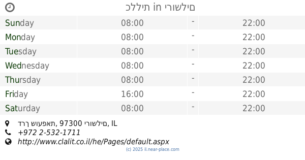
contacts phone
:
+972
Latitude:
31.809365
, Longitude:
35.233066
read more
nearest Health
כללית התפתחות הילד
דרך שועפאת, ירושלים
Health
read more
388 m
לב הפנינה טיפול הוליסטי הרצאות וסדנאות
מבוא העשרה 7, ירושלים
Health
read more
403 m
כללית
דרך שועפאת, ירושלים
Health
read more
403 m
Поликлиника Клалит
Derech Shua'fat, Jerusalem
Health
read more
554 m
صيدلية شعفاط
Shu'afat - Main street, ירושלים
Health
read more
762 m
נשיותי
Midbar Sinai Street 37, Jerusalem
Health
read more
803 m
קופח כללית
בלאל בן רבאך 17, ירושלים
Health
read more
894 m
כללית
בר כוכבא 64, ירושלים
Health
read more
894 m
Поликлиника Клалит
Bar Kochva Street 64, Jerusalem
Health
read more
894 m
כללית
Bar Kochva Street 64, Jerusalem
Health
read more
1.072 km
Home for the elderly
Jerusalem
Health
read more
1.11 km
ארוכה ומרפא
ירושלים
Health
read more
1.11 km
ארוכה ומרפא
Jerusalem
Health
read more
1.133 km
כללית - מרכז בריאות האישה
פארן 12, ירושלים
Health
read more
1.133 km
General - Women's Health Center
פארן 12, Jerusalem
Health
read more
📑
all categories
Accounting
Administrative area level 1
Administrative area level 2
Airport
Amusement park
Aquarium
Art gallery
Atm
Bakery
Bank
Bar
Beauty salon
Bicycle store
Book store
Bowling alley
Bus station
Cafe
Campground
Car dealer
Car rental
Car repair
Car wash
Casino
Cemetery
Church
City hall
Clothing store
Colloquial area
Convenience store
Country
Courthouse
Dentist
Department store
Doctor
Electrician
Electronics store
Embassy
Establishment
Finance
Fire station
Florist
Food
Funeral home
Furniture store
Gas station
General contractor
Grocery or supermarket
Gym
Hair care
Hardware store
Health
Hindu Temple
Home goods store
Hospital
Insurance agency
Intersection
Jewelry store
Laundry
Lawyer
Library
Light rail station
Liquor store
Local government office
Locality
Locksmith
Lodging
Meal delivery
Meal takeaway
Mosque
Movie rental
Movie theater
Moving company
Museum
Natural feature
Neighborhood
Night club
Painter
Park
Parking
Pet store
Pharmacy
Physiotherapist
Place of worship
Plumber
Point of interest
Police
Political
Post office
Premise
Real estate agency
Restaurant
Roofing contractor
Route
Rv park, camping
School
Shoe store
Shopping mall
Spa
Stadium
Storage
Store
Subpremise
Subway station
Supermarket
Synagogue
Taxi stand
Train station
Transit station
Travel agency
University
Veterinary care
Zoo
administrative area level 3
administrative area level 4
sublocality level 1
↑