Health nearby Karate School led by Michael Abigdol
Israel
Health nearby Karate School led by Michael Abigdol
Karate School led by Michael Abigdol
Simtat Tsviya Lubetkin, Giv'atayim, IL Израиль
contacts phone
:
+972
website:
www.karate-telaviv.co.il
Latitude:
32.06392
, Longitude:
34.8130151
larger map & directions
read more
nearest Health
434 m
דר דוד דויטש
Derech Yitshak Rabin 53, Giv'atayim
Hospital
Health
Point of interest
Establishment
read more
538 m
פרופ' רענן ברגר
Revivim Street, Giv'atayim
Hospital
Health
Point of interest
Establishment
read more
608 m
מדיטסט בדיקות (2007) בעמ
Tfutsot Yisra'el Street 6א, Giv'atayim
Hospital
Health
Point of interest
Establishment
read more
699 m
נשימה מודעת - הבחירה בחיים
Ascherman Street 3, Tel Aviv-Yafo
Health
read more
749 m
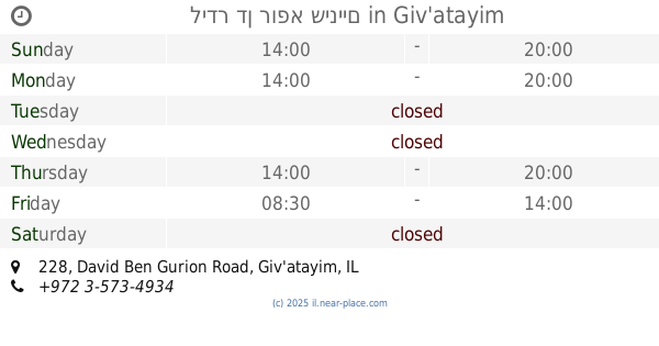
לידר דן רופא שיניים
David Ben Gurion Road 228, Giv'atayim
Dentist
Health
Point of interest
Establishment
read more
753 m
רופא שיניים בתל אביב מרפאת שיניים שביט - דוקטור הילה צפורן
HaShalom Road 105, Tel Aviv-Yafo
Dentist
Health
Point of interest
Establishment
read more
772 m
אברהמי דורון
דרך השלום 101, תל אביב יפו
Health
read more
816 m
Clinical Psychologist, Dr. Nitzan Shrira, Psy.D
Oded Street 11, Ramat Gan
Health
read more
816 m
Clinical Psychologist, Dr. Nitzan Shrira, Psy.D
עודד 11, רמת גן
Health
read more
1.149 km
ניר מאמן כושר אישי ומדריך שחייה פרטי
Enzo Sereni Street 6, Giv'atayim
Health
read more
1.282 km
בית הורים אניטה מילר כהן
רזיאל 28, רמת גן
Health
read more
1.282 km
Anita Miller Cohen Parents House
רזיאל 28, Ramat Gan
Health
read more
1.286 km
מרפאת דר גנדלמן
Uzi'el Street 76, Ramat Gan
Dentist
Health
Point of interest
Establishment
read more
1.307 km
חברת מעונות הורים בע"מ
רזיאל 30, רמת גן
Health
read more
1.307 km
חברת מעונות הורים בעמ
Raziel Street 30, Ramat Gan
Health
read more
📑
all categories
Accounting
Administrative area level 1
Administrative area level 2
Airport
Amusement park
Aquarium
Art gallery
Atm
Bakery
Bank
Bar
Beauty salon
Bicycle store
Book store
Bowling alley
Bus station
Cafe
Campground
Car dealer
Car rental
Car repair
Car wash
Casino
Cemetery
Church
City hall
Clothing store
Colloquial area
Convenience store
Country
Courthouse
Dentist
Department store
Doctor
Electrician
Electronics store
Embassy
Establishment
Finance
Fire station
Florist
Food
Funeral home
Furniture store
Gas station
General contractor
Grocery or supermarket
Gym
Hair care
Hardware store
Health
Hindu Temple
Home goods store
Hospital
Insurance agency
Intersection
Jewelry store
Laundry
Lawyer
Library
Light rail station
Liquor store
Local government office
Locality
Locksmith
Lodging
Meal delivery
Meal takeaway
Mosque
Movie rental
Movie theater
Moving company
Museum
Natural feature
Neighborhood
Night club
Painter
Park
Parking
Pet store
Pharmacy
Physiotherapist
Place of worship
Plumber
Point of interest
Police
Political
Post office
Premise
Real estate agency
Restaurant
Roofing contractor
Route
Rv park, camping
School
Shoe store
Shopping mall
Spa
Stadium
Storage
Store
Subpremise
Subway station
Supermarket
Synagogue
Taxi stand
Train station
Transit station
Travel agency
University
Veterinary care
Zoo
administrative area level 3
administrative area level 4
sublocality level 1
↑