Health nearby جمعية مبرة فلسطين ( مركز سجى )
Israel
Health nearby جمعية مبرة فلسطين ( مركز سجى )
جمعية مبرة فلسطين ( مركز سجى )
جمعية مبرة فلسطين ( مركز سجى
contacts phone
:
+972 59-421-7149
Latitude:
31.5389939
, Longitude:
34.4564342
larger map & directions
read more
nearest Health
554 m
مستشفى العيون الحكومى
GFM5+VQW, تقاطع شارع النصر مع Abu Dhabi - Al Ain Road, Ghazzah
Hospital
Health
Point of interest
Establishment
read more
682 m
Victory Children's Hospital
GFM5+7GF, Mohammed Kandeel, Giza
Hospital
Point of interest
Health
Establishment
read more
705 m
Beauty smile
GFM4+399, Gaza
Dentist
Health
Point of interest
Establishment
read more
839 m
صيدلية الفؤاد فارم
Azza Street, Jerusalem
Health
read more
839 m
صيدلية الفؤاد فارم
דרך עזה, ירושלים
Health
read more
893 m
Ranteesi Specialist Hospital
GFJ6+VH6, El-Nasr, Giza
Hospital
Health
Point of interest
Establishment
read more
915 m
عيادة الاسنان التخصصية الدكتور مهند فتحي فياض
شارع صلاح خلف، غزة،
Dentist
Health
Point of interest
Establishment
read more
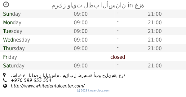
1.024 km
مركز وايت لطب الأسنان
شارع عز الدين القسام ، مقابل طرمبة أبو حليمة, غزة
Dentist
Health
Point of interest
Establishment
read more
1.068 km
عيادة السلامة الطبية الدكتور أشرف عبيد
شارع, Ezbet Ahmed Abd El-Hady
Health
read more
1.587 km
عيادة الدكتور أحمد محمد المدهون
Unnamed Road
Health
read more
1.845 km
Hijazi Clinic
جباليا، التوام
Health
read more
2.026 km
مختبر شاكر للتحاليل الطبية
شارع الوحدة عمارة البورنو مقابل مستشفى الشفاء
Health
read more
2.127 km
مختبر ابن الهيثم
مقابل مستشفي الشفاء بجانب محطة الخزندار .غزة
Health
read more
2.195 km
Nedal Pharmacy
Omar Mukhtar Street
Health
read more
2.332 km
شركة انتربال للتوريدات الطبية
مفترق العباس غزة قطاع غزة
Health
read more
📑
all categories
Accounting
Administrative area level 1
Administrative area level 2
Airport
Amusement park
Aquarium
Art gallery
Atm
Bakery
Bank
Bar
Beauty salon
Bicycle store
Book store
Bowling alley
Bus station
Cafe
Campground
Car dealer
Car rental
Car repair
Car wash
Casino
Cemetery
Church
City hall
Clothing store
Colloquial area
Convenience store
Country
Courthouse
Dentist
Department store
Doctor
Electrician
Electronics store
Embassy
Establishment
Finance
Fire station
Florist
Food
Funeral home
Furniture store
Gas station
General contractor
Grocery or supermarket
Gym
Hair care
Hardware store
Health
Hindu Temple
Home goods store
Hospital
Insurance agency
Intersection
Jewelry store
Laundry
Lawyer
Library
Light rail station
Liquor store
Local government office
Locality
Locksmith
Lodging
Meal delivery
Meal takeaway
Mosque
Movie rental
Movie theater
Moving company
Museum
Natural feature
Neighborhood
Night club
Painter
Park
Parking
Pet store
Pharmacy
Physiotherapist
Place of worship
Plumber
Point of interest
Police
Political
Post office
Premise
Real estate agency
Restaurant
Roofing contractor
Route
Rv park, camping
School
Shoe store
Shopping mall
Spa
Stadium
Storage
Store
Subpremise
Subway station
Supermarket
Synagogue
Taxi stand
Train station
Transit station
Travel agency
University
Veterinary care
Zoo
administrative area level 3
administrative area level 4
sublocality level 1
↑