Gym nearby Top Fitness
Israel
Gym nearby Top Fitness
Top Fitness
nablus mall, Nablus
contacts phone
:
+972
Latitude:
32.2239854
, Longitude:
35.2540581
larger map & directions
read more
nearest Gym
287 m
Nablus stadion
rafidia street
Gym
read more
22.848 km
super body
אלכינא, Tayibe
Gym
read more
22.866 km
CrossFit Shimshon
None, Tzur Natan
Gym
read more
23.262 km
Almujamma Al-Islami
דרך יפו, טייבה
Gym
read more
23.557 km
النادي الاولمبي للسيدات
دخلة الارتباط المدني
Gym
read more
23.626 km
مركز حواء للياقة البدنية
Tolkarem Street, Irbid
Gym
read more
23.675 km
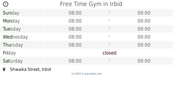
Free Time Gym
Shwaika Street, Irbid
Gym
read more
24.065 km
Ornetpower
mahsom shaar Ephraim
Gym
read more
24.272 km
Pilates & More
נחל אלכסנדר 5, צור יצחק
Gym
read more
24.302 km
Samuel Lederman
Nahal Kane Street 6, Tzur Yitzhak
Gym
read more
24.334 km
Doctor gym
טייבה
Gym
read more
24.334 km
Doctor gym
Tayibe
Gym
read more
25.164 km
בר פילאטיס
שדרות השומרון 32, בת חפר
Gym
read more
25.164 km
בר פילאטיס
Sderot HaShomron 32, Bat Hefer
Gym
read more
25.497 km
ergo4u Ltd
Gil'ad Street 23, Bat Hefer
Gym
read more
25.518 km
יוגה שאלא באורנית
Atsmon Street 2, Oranit
Gym
read more
25.518 km
יוגה שאלא באורנית
עצמון 2, אורנית
Gym
read more
25.558 km
אורלי יערי יוגה בבת חפר ובעמק חפר
Gil'ad Street 30, Bat Hefer
Gym
read more
25.558 km
אורלי יערי יוגה בבת חפר ובעמק חפר
גלעד 30, בת חפר
Gym
read more
26.959 km
קאנטרי אורנית
מבוא אורנית 3, אורנית
Gym
read more
26.959 km
Country Oranit
מבוא אורנית 3, Oranit
Gym
read more
27.224 km
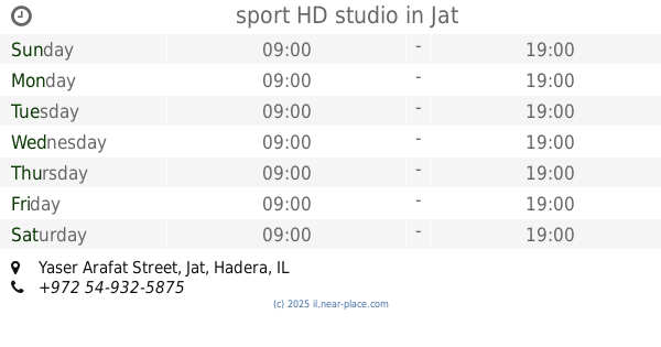
sport HD studio
יאסר ערפאת, ג'ת
Gym
read more
27.224 km
sport HD studio
Yaser Arafat Street, Jat
Gym
read more
29.567 km
Sport Zoher
Baqa al-Gharbiyye
Gym
read more
32.228 km
יוגה עמק חפר- המרכז ליוגה ובריאות
אגוז 127, מאור
Gym
read more
📑
all categories
Accounting
Administrative area level 1
Administrative area level 2
Airport
Amusement park
Aquarium
Art gallery
Atm
Bakery
Bank
Bar
Beauty salon
Bicycle store
Book store
Bowling alley
Bus station
Cafe
Campground
Car dealer
Car rental
Car repair
Car wash
Casino
Cemetery
Church
City hall
Clothing store
Colloquial area
Convenience store
Country
Courthouse
Dentist
Department store
Doctor
Electrician
Electronics store
Embassy
Establishment
Finance
Fire station
Florist
Food
Funeral home
Furniture store
Gas station
General contractor
Grocery or supermarket
Gym
Hair care
Hardware store
Health
Hindu Temple
Home goods store
Hospital
Insurance agency
Intersection
Jewelry store
Laundry
Lawyer
Library
Light rail station
Liquor store
Local government office
Locality
Locksmith
Lodging
Meal delivery
Meal takeaway
Mosque
Movie rental
Movie theater
Moving company
Museum
Natural feature
Neighborhood
Night club
Painter
Park
Parking
Pet store
Pharmacy
Physiotherapist
Place of worship
Plumber
Point of interest
Police
Political
Post office
Premise
Real estate agency
Restaurant
Roofing contractor
Route
Rv park, camping
School
Shoe store
Shopping mall
Spa
Stadium
Storage
Store
Subpremise
Subway station
Supermarket
Synagogue
Taxi stand
Train station
Transit station
Travel agency
University
Veterinary care
Zoo
administrative area level 3
administrative area level 4
sublocality level 1
↑