Gym nearby صالة ابو يوسف النجار
Israel
Gym nearby صالة ابو يوسف النجار
صالة ابو يوسف النجار
Okręg Gazy
contacts phone
:
+972
Latitude:
31.347706
, Longitude:
34.296763
larger map & directions
read more
nearest Gym
18 m
His father Joseph Hall
2 5، Tel Aviv-Yafo
Gym
read more
195 m
Khan Services Center
Gym
read more
13.46 km
מועדון לאומנויות לחימה ''שו ריו קאן''
מגן
Gym
read more
20.037 km
Beeri Spinning Club
Be'eri
Gym
read more
20.037 km
Beeri Spinning Club
בארי
Gym
read more
22.959 km
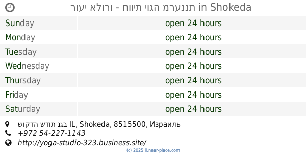
רועי אלורו - חווית יוגה מרעננת
שוקדה שדות נגב IL
Gym
read more
23.355 km
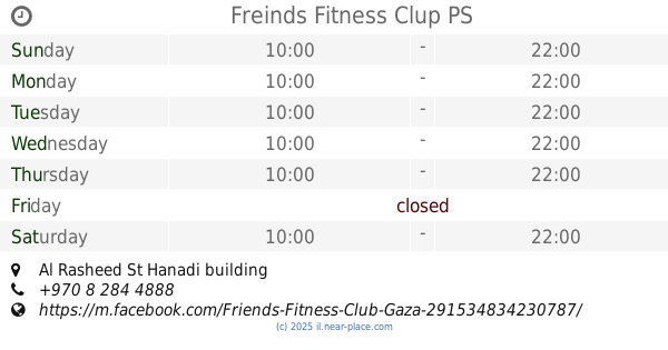
Freinds Fitness Clup
Al Rasheed St Hanadi building
Gym
read more
23.479 km
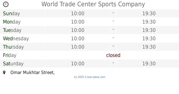
World Trade Center Sports Company
Omar Mukhtar Street
Gym
read more
23.523 km
نادي غزة الرياضي
Al-Shuhada Street, Kuwait City
Gym
read more
24.131 km
مركز هولست الثقافي
Shaaban
Gym
read more
24.321 km
Saad Sayel gym
غزة ملعب فلسطين
Gym
read more
25.675 km
صالة اليازجي
اليرموك محمص ومكسرات اليازجي
Gym
read more
25.91 km
Friendship Sports Club
Gym
read more
26.338 km
חדר כושר צעד בסעד מרסלו דובינובסקי Marcelo Dubinowski
Sa'ad
Gym
read more
26.338 km
חדר כושר צעד בסעד מרסלו דובינובסקי Marcelo Dubinowski
סעד
Gym
read more
28.931 km
Red Dragon School Sports
مشروع بيت لاهيا_شارع العطل
Gym
read more
30.478 km
منتجع النورس غزة
Gym
read more
43.234 km
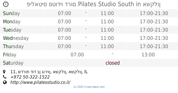
פילאטיס סטודיו דרום Pilates Studio South
שדרות דוד בן גוריון 11, אשקלון
Gym
read more
44.524 km
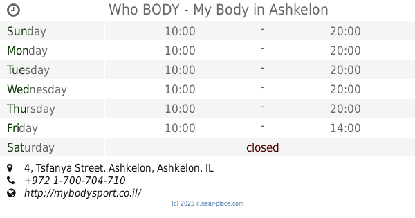
Who BODY - My Body
Tsfanya Street 4, Ashkelon
Gym
read more
49.026 km
Spirit Sport Club MMA
Tsabar Street 26, Be'er Sheva
Gym
read more
49.03 km
Livyoga
Rotem Street 34, Be'er Sheva
Gym
read more
50.082 km
סטודיו לאימונים פונקציונאליים muscleup
המרד 13/1, Be'er Sheva
Gym
read more
53.432 km
Life & Fitness Ofir
Harimon Street 70, Kiryat Gat
Gym
read more
59.397 km
יוגה ברקפת
הרקפת 5, אשדוד
Gym
read more
61.095 km
חדר כושר לזוז
הכישור 23, גן יבנה
Gym
read more
📑
all categories
Accounting
Administrative area level 1
Administrative area level 2
Airport
Amusement park
Aquarium
Art gallery
Atm
Bakery
Bank
Bar
Beauty salon
Bicycle store
Book store
Bowling alley
Bus station
Cafe
Campground
Car dealer
Car rental
Car repair
Car wash
Casino
Cemetery
Church
City hall
Clothing store
Colloquial area
Convenience store
Country
Courthouse
Dentist
Department store
Doctor
Electrician
Electronics store
Embassy
Establishment
Finance
Fire station
Florist
Food
Funeral home
Furniture store
Gas station
General contractor
Grocery or supermarket
Gym
Hair care
Hardware store
Health
Hindu Temple
Home goods store
Hospital
Insurance agency
Intersection
Jewelry store
Laundry
Lawyer
Library
Light rail station
Liquor store
Local government office
Locality
Locksmith
Lodging
Meal delivery
Meal takeaway
Mosque
Movie rental
Movie theater
Moving company
Museum
Natural feature
Neighborhood
Night club
Painter
Park
Parking
Pet store
Pharmacy
Physiotherapist
Place of worship
Plumber
Point of interest
Police
Political
Post office
Premise
Real estate agency
Restaurant
Roofing contractor
Route
Rv park, camping
School
Shoe store
Shopping mall
Spa
Stadium
Storage
Store
Subpremise
Subway station
Supermarket
Synagogue
Taxi stand
Train station
Transit station
Travel agency
University
Veterinary care
Zoo
administrative area level 3
administrative area level 4
sublocality level 1
↑