Gym nearby מגרש כדורסל
Israel
Gym nearby מגרש כדורסל
מגרש כדורסל
Negba, Israel
contacts phone
:
+972
Latitude:
31.657563
, Longitude:
34.682763
larger map & directions
read more
nearest Gym
9.824 km
Profit
Harimon Street 21, Kiryat Gat
Gym
read more
9.83 km
Life & Fitness Ofir
Harimon Street 70, Kiryat Gat
Gym
read more
9.83 km
Life & Fitness Ofir
הרימון 70, קרית גת
Gym
read more
10.442 km
חדר כושר profit באר טוביה
ניר
Gym
read more
10.633 km
Big Gym
עליית הנוער 6, אשקלון
Gym
read more
10.663 km
Movement Studio
Khalutsei ha-Ta'asiya Street 2, Kiryat Malakhi
Gym
read more
10.879 km
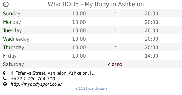
Who BODY - My Body
Tsfanya Street 4, Ashkelon
Gym
read more
10.879 km
מי בודי - My Body
צפניה 4, אשקלון
Gym
read more
11.155 km
Sport Department from Ashkelon Municipality
Koresh Street, Ashkelon
Gym
read more
11.372 km
יוגה ופילאטיס סטודיו-בוטיק ג'וטי באשקלון йога в Ашкелоне
רח' הגבורה 1, קומה 2, פאר סנטר Davidy, אשקלון
Gym
read more
11.851 km
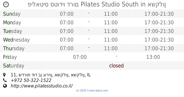
פילאטיס סטודיו דרום Pilates Studio South
שדרות דוד בן גוריון 11, אשקלון
Gym
read more
12.2 km
Hankin Studio Liat personal and group training
Be'er Tuvia
Gym
read more
12.2 km
ליאת חנקין סטודיו לאימונים אישיים וקבוצתיים
באר טוביה
Gym
read more
12.379 km
MySport
hof Dlila, אשקלון
Gym
read more
12.379 km
MySport
hof Dlila, Ashkelon
Gym
read more
13.146 km
Gym move
Ha-Kishor Street 23, Gan Yavne
Gym
read more
13.146 km
חדר כושר לזוז
הכישור 23, גן יבנה
Gym
read more
13.152 km
De Rock & Run Fitness
Gan Yavne
Gym
read more
13.359 km
Get shaped studio
ביג פשאן, אשדוד
Gym
read more
13.468 km
סטודיו ליאת חן
המייסדים 90, שתולים
Gym
read more
13.468 km
סטודיו ליאת חן
HaMeyasdim 90, Shtulim
Gym
read more
14.489 km
יוגה ברקפת
הרקפת 5, אשדוד
Gym
read more
15.179 km
מועדון הריצה רצים עם הרוח
Shiryon Street, Gan Yavne
Gym
read more
15.45 km
גו אקטיב אשדוד
הגדוד העברי, אשדוד
Gym
read more
17.972 km
איריס פילאטיס
רבדים
Gym
read more
📑
all categories
Accounting
Administrative area level 1
Administrative area level 2
Airport
Amusement park
Aquarium
Art gallery
Atm
Bakery
Bank
Bar
Beauty salon
Bicycle store
Book store
Bowling alley
Bus station
Cafe
Campground
Car dealer
Car rental
Car repair
Car wash
Casino
Cemetery
Church
City hall
Clothing store
Colloquial area
Convenience store
Country
Courthouse
Dentist
Department store
Doctor
Electrician
Electronics store
Embassy
Establishment
Finance
Fire station
Florist
Food
Funeral home
Furniture store
Gas station
General contractor
Grocery or supermarket
Gym
Hair care
Hardware store
Health
Hindu Temple
Home goods store
Hospital
Insurance agency
Intersection
Jewelry store
Laundry
Lawyer
Library
Light rail station
Liquor store
Local government office
Locality
Locksmith
Lodging
Meal delivery
Meal takeaway
Mosque
Movie rental
Movie theater
Moving company
Museum
Natural feature
Neighborhood
Night club
Painter
Park
Parking
Pet store
Pharmacy
Physiotherapist
Place of worship
Plumber
Point of interest
Police
Political
Post office
Premise
Real estate agency
Restaurant
Roofing contractor
Route
Rv park, camping
School
Shoe store
Shopping mall
Spa
Stadium
Storage
Store
Subpremise
Subway station
Supermarket
Synagogue
Taxi stand
Train station
Transit station
Travel agency
University
Veterinary care
Zoo
administrative area level 3
administrative area level 4
sublocality level 1
↑