Gym nearby Metro Givatayim
Israel
Gym nearby Metro Givatayim
Metro Givatayim
27, Aliyat ha-No'ar Street, Giv'atayim, IL Израиль
contacts phone
:
+972 3-672-9672
website:
www.metrogym.co.il
Latitude:
32.0748644
, Longitude:
34.8017532
larger map & directions
read more
nearest Gym
283 m
Wing chun club
Hafes Haim Street 10, Tel Aviv-Yafo
Gym
read more
285 m
Yaron Lahav Pilates studio
Hafes Haim Street 10, Tel Aviv-Yafo
Gym
read more
285 m
Yaron Lahav Pilates studio
חפץ חיים 10, תל אביב יפו
Gym
read more
544 m
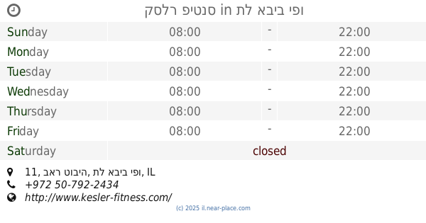
קסלר פיטנס
באר טוביה 11 Tel Aviv Yafo IL 6744356, Be'er Tuvya 11, Tel Aviv-Yafo
Gym
read more
544 m
קסלר פיטנס
באר טוביה 11 Tel Aviv Yafo IL 6744356, באר טוביה 11, תל אביב יפו
Gym
read more
562 m
גן זינגר רפפורט
דרך השלום, תל אביב יפו
Gym
read more
562 m
גן זינגר רפפורט
HaShalom Road, Tel Aviv-Yafo
Gym
read more
626 m
הסטודיו לפילאטיס של שני גבעתיים
חביבה רייק 1, גבעתיים
Gym
read more
658 m
Prana Yoga
Weizman Street 19, Giv'atayim
Gym
read more
670 m
Iron Core
בן שמן 3, תל אביב יפו
Gym
read more
670 m
Iron Core
Ben Shemen Street 3, Tel Aviv-Yafo
Gym
read more
674 m
יוגה עדנה בן סימון
Ha-Me'orer Street 16, Giv'atayim
Gym
read more
674 m
יוגה איינגר גבעתיים רמת גן
המעורר 16, גבעתיים
Gym
read more
674 m
יוגה איינגר גבעתיים רמת גן
Ha-Me'orer Street 16, Giv'atayim
Gym
read more
698 m
גופאני
דוד רמז 17, גבעתיים
Gym
read more
734 m
בריכת רמבם ספורטר גבעתיים
Eilat Street 8, Giv'atayim
Gym
read more
904 m
הולמס פלייס
מגדלי עזריאלי, Derech Menachem Begin, Tel Aviv-Yafo
Gym
read more
932 m
Body Motion
Ze'ev Jabotinsky Street 7, Ramat Gan
Gym
read more
934 m
בניין משה אביב
דרך זאב ז'בוטינסקי 7, רמת גן
Gym
read more
946 m
זאוס
דרך זאב ז'בוטינסקי 7, רמת גן
Gym
read more
946 m
Зеус
Ze'ev Jabotinsky Road 7, Ramat Gan
Gym
read more
1.085 km
לוליפופ - סטודיו לכושר וחיטוב הגוף
יוסף קארו 19, תל אביב יפו
Gym
read more
1.126 km
MorePilates
שדרות ההשכלה 9, תל אביב יפו
Gym
read more
1.126 km
MorePilates
Sderot HaHaskala 9, Tel Aviv-Yafo
Gym
read more
1.262 km
גינת כלבים
Sderot Nehama 6-8, Ramat Gan
Gym
read more
📑
all categories
Accounting
Administrative area level 1
Administrative area level 2
Airport
Amusement park
Aquarium
Art gallery
Atm
Bakery
Bank
Bar
Beauty salon
Bicycle store
Book store
Bowling alley
Bus station
Cafe
Campground
Car dealer
Car rental
Car repair
Car wash
Casino
Cemetery
Church
City hall
Clothing store
Colloquial area
Convenience store
Country
Courthouse
Dentist
Department store
Doctor
Electrician
Electronics store
Embassy
Establishment
Finance
Fire station
Florist
Food
Funeral home
Furniture store
Gas station
General contractor
Grocery or supermarket
Gym
Hair care
Hardware store
Health
Hindu Temple
Home goods store
Hospital
Insurance agency
Intersection
Jewelry store
Laundry
Lawyer
Library
Light rail station
Liquor store
Local government office
Locality
Locksmith
Lodging
Meal delivery
Meal takeaway
Mosque
Movie rental
Movie theater
Moving company
Museum
Natural feature
Neighborhood
Night club
Painter
Park
Parking
Pet store
Pharmacy
Physiotherapist
Place of worship
Plumber
Point of interest
Police
Political
Post office
Premise
Real estate agency
Restaurant
Roofing contractor
Route
Rv park, camping
School
Shoe store
Shopping mall
Spa
Stadium
Storage
Store
Subpremise
Subway station
Supermarket
Synagogue
Taxi stand
Train station
Transit station
Travel agency
University
Veterinary care
Zoo
administrative area level 3
administrative area level 4
sublocality level 1
↑