Gas station nearby Tal Be'er Sheva Ha-Melakha
Israel
Gas station nearby Tal Be'er Sheva Ha-Melakha
Tal Be'er Sheva Ha-Melakha
Be'er Sheva, Israel
contacts phone
:
+972
Latitude:
31.236816
, Longitude:
34.79636
larger map & directions
read more
nearest Gas station
11 m
תחנת דלק יעד
Be'er Sheva
Gas station
read more
232 m
Delek Delarom
Derekh Hebron 4, Be'er Sheva
Gas station
read more
232 m
דלק מנטה
באר שבע
Gas station
read more
232 m
דלק דלרום
דרך חברון 4, באר שבע
Gas station
read more
254 m
סונול נחל באר שבע
באר שבע
Gas station
read more
254 m
Sonol Nahal Beersheba
Be'er Sheva
Gas station
read more
287 m
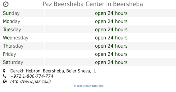
פז באר שבע מרכז
דרך חברון, באר שבע
Gas station
read more
287 m
Paz Beersheba Center
Derekh Hebron, Be'er Sheva
Gas station
read more
296 m
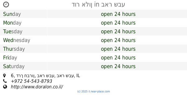
דור אלון
דרך חברון 6, באר שבע
Gas station
read more
720 m
תחנת דלק פטרול
באר שבע
Gas station
read more
797 m
דלק נווה צאלים
באר שבע
Gas station
read more
797 m
Delek Neve Tse'elim
Be'er Sheva
Gas station
read more
916 m
Tan Gas Station Beersheba Hebron Road
Derekh Hebron 48, Be'er Sheva
Gas station
read more
939 m
תחנת דלק תפוז
Derekh Hebron 25, Be'er Sheva
Gas station
read more
939 m
תחנת דלק תפוז
דרך חברון 25, באר שבע
Gas station
read more
1.387 km
Paz
שדרות שז"ר, Be'er Sheva
Gas station
read more
1.387 km
פז קרית הממשלה
שדרות שז"ר, באר שבע
Gas station
read more
1.489 km
שיכון עובדים
באר שבע
Gas station
read more
1.682 km
סדש עמק שרה
באר שבע
Gas station
read more
1.689 km
ממתחם פז סנטר באר שבע צפון
Sderot Yerushalayim 4, Be'er Sheva
Gas station
read more
1.689 km
ממתחם פז סנטר באר שבע צפון
שדרות ירושלים 4, באר שבע
Gas station
read more
1.691 km
Derekh Khevron
Be'er Sheva
Gas station
read more
1.7 km
Ten Gas station תחנת דלק טן
באר שבע
Gas station
read more
1.846 km
סדש-טוביהו
Be'er Sheva
Gas station
read more
1.987 km
פז אצטדיון בש
דרך שמשון, באר שבע
Gas station
read more
📑
all categories
Accounting
Administrative area level 1
Administrative area level 2
Airport
Amusement park
Aquarium
Art gallery
Atm
Bakery
Bank
Bar
Beauty salon
Bicycle store
Book store
Bowling alley
Bus station
Cafe
Campground
Car dealer
Car rental
Car repair
Car wash
Casino
Cemetery
Church
City hall
Clothing store
Colloquial area
Convenience store
Country
Courthouse
Dentist
Department store
Doctor
Electrician
Electronics store
Embassy
Establishment
Finance
Fire station
Florist
Food
Funeral home
Furniture store
Gas station
General contractor
Grocery or supermarket
Gym
Hair care
Hardware store
Health
Hindu Temple
Home goods store
Hospital
Insurance agency
Intersection
Jewelry store
Laundry
Lawyer
Library
Light rail station
Liquor store
Local government office
Locality
Locksmith
Lodging
Meal delivery
Meal takeaway
Mosque
Movie rental
Movie theater
Moving company
Museum
Natural feature
Neighborhood
Night club
Painter
Park
Parking
Pet store
Pharmacy
Physiotherapist
Place of worship
Plumber
Point of interest
Police
Political
Post office
Premise
Real estate agency
Restaurant
Roofing contractor
Route
Rv park, camping
School
Shoe store
Shopping mall
Spa
Stadium
Storage
Store
Subpremise
Subway station
Supermarket
Synagogue
Taxi stand
Train station
Transit station
Travel agency
University
Veterinary care
Zoo
administrative area level 3
administrative area level 4
sublocality level 1
↑