Gas station nearby Sonol Aviv
Israel
Gas station nearby Sonol Aviv
Sonol Aviv
Tel Aviv, Israel
contacts phone
:
+972 54-673-3525
website:
www.sonol.co.il
Latitude:
32.13157
, Longitude:
34.795687
larger map & directions
read more
nearest Gas station
654 m
פז למד הכניסה לבור
תל אביב יפו
Gas station
read more
654 m
Paz
Tel Aviv-Yafo
Gas station
read more
654 m
Paz Lamed
Tel Aviv-Yafo
Gas station
read more
1.965 km
תחנת דלק סונול
רמת השרון
Gas station
read more
2.943 km
פז רונית
צומת הסירה יציאה מהרצליה, הרצליה
Gas station
read more
2.943 km
פז רונית
צומת הסירה יציאה מהרצליה, Herzliya
Gas station
read more
2.961 km
Delek
Namir Road 170, Tel Aviv-Yafo
Gas station
read more
2.983 km
מתחם פז סנטר רונית הרצליה
Highway 2, Herzliya
Gas station
read more
3.203 km
Paz Eshel Herzliya
צומת הסירה, Herzliya
Gas station
read more
3.203 km
פז אשל הרצליה
צומת הסירה, הרצליה
Gas station
read more
3.274 km
תחנת פז יריד הקטנה
Rokach Boulevard 99, Tel Aviv-Yafo
Gas station
read more
3.274 km
תחנת פז יריד הקטנה
שדרות רוקח 99, תל אביב יפו
Gas station
read more
3.289 km
paz yarid ktana gas station
Rokach Boulevard 99, Tel Aviv-Yafo
Gas station
read more
3.289 km
paz yarid ktana gas station
שדרות רוקח 99, תל אביב יפו
Gas station
read more
3.342 km
פז יריד מזרח גדולה
שדרות רוקח 104, תל אביב יפו
Gas station
read more
3.342 km
Paz
Rokach Boulevard 104, Tel Aviv-Yafo
Gas station
read more
3.436 km
דלק רמת השרון
Moshe Sneh Street 210, Ramat Hasharon
Gas station
read more
4.665 km
Азс
Mivtsa Kadesh Street 56-60, Bnei Brak
Gas station
read more
4.8 km
תחנת דלק פז
הרב קוק 74, הרצליה
Gas station
read more
4.859 km
Fuel Amir
Ha-Yarkon Street 10, Bnei Brak
Gas station
read more
4.861 km
Ofir
Bnei Brak
Gas station
read more
5.203 km
דלק רמה
זאב זבוטינסקי 67, רמת גן
Gas station
read more
5.212 km
Dor Alon
Ze'ev Jabotinsky Street 5, Bnei Brak
Gas station
read more
5.212 km
דור אלון
רח' זאב ז'בוטינסקי 5, בני ברק
Gas station
read more
6.102 km
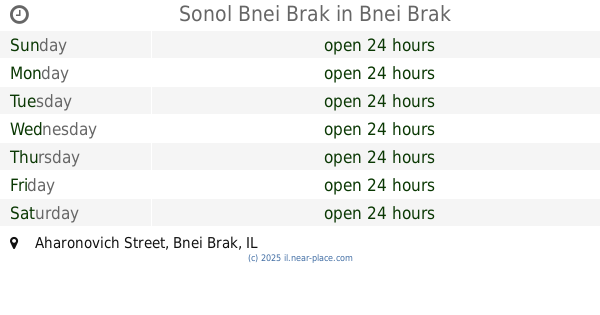
Sonol Bnei Brak
Aharonovich Street, Bnei Brak
Gas station
read more
📑
all categories
Accounting
Administrative area level 1
Administrative area level 2
Airport
Amusement park
Aquarium
Art gallery
Atm
Bakery
Bank
Bar
Beauty salon
Bicycle store
Book store
Bowling alley
Bus station
Cafe
Campground
Car dealer
Car rental
Car repair
Car wash
Casino
Cemetery
Church
City hall
Clothing store
Colloquial area
Convenience store
Country
Courthouse
Dentist
Department store
Doctor
Electrician
Electronics store
Embassy
Establishment
Finance
Fire station
Florist
Food
Funeral home
Furniture store
Gas station
General contractor
Grocery or supermarket
Gym
Hair care
Hardware store
Health
Hindu Temple
Home goods store
Hospital
Insurance agency
Intersection
Jewelry store
Laundry
Lawyer
Library
Light rail station
Liquor store
Local government office
Locality
Locksmith
Lodging
Meal delivery
Meal takeaway
Mosque
Movie rental
Movie theater
Moving company
Museum
Natural feature
Neighborhood
Night club
Painter
Park
Parking
Pet store
Pharmacy
Physiotherapist
Place of worship
Plumber
Point of interest
Police
Political
Post office
Premise
Real estate agency
Restaurant
Roofing contractor
Route
Rv park, camping
School
Shoe store
Shopping mall
Spa
Stadium
Storage
Store
Subpremise
Subway station
Supermarket
Synagogue
Taxi stand
Train station
Transit station
Travel agency
University
Veterinary care
Zoo
administrative area level 3
administrative area level 4
sublocality level 1
↑