Gas station nearby Paz Kiryat Ono
Israel
Gas station nearby Paz Kiryat Ono
Paz Kiryat Ono
23, Derech Levi Eshkol, Kiryat Ono, IL Израиль
contacts phone
:
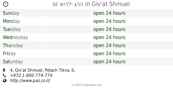
+972 1-800-774-774
website:
www.paz.co.il
Latitude:
32.0637877
, Longitude:
34.8616116
larger map & directions
read more
nearest Gas station
2.08 km
תחנת דלק פז יציב
Bnei Brak
Gas station
read more
2.085 km
АЗС по дороге в аэропорт
Bnei Brak
Gas station
read more
2.09 km
פז יציב
כביש גהה, בני ברק
Gas station
read more
2.411 km
טן גבעת שמואל
Ha-Sivim Street 51, Petah Tikva
Gas station
read more
2.431 km
טן גבעת שמואל
הסיבים 51, פתח תקווה
Gas station
read more
2.472 km
Delek Bnei Brak
HaRav Kahanman Street 96, Bnei Brak
Gas station
read more
2.472 km
Delek
HaRav Kahanman Street 96, Bnei Brak
Gas station
read more
2.472 km
דלק בני ברק
HaRav Kahanman Street 96, Bnei Brak
Gas station
read more
2.485 km
תחנת דלק פז גהה
יונה שפינדל, גבעת שמואל
Gas station
read more
2.485 km
Geha Gas Station
Yona Shpindel Street, Giv'at Shmuel
Gas station
read more
2.496 km
פז אורלי גהה
4, גבעת שמואל
Gas station
read more
2.496 km
פז אורלי גהה
4, Giv'at Shmuel
Gas station
read more
2.655 km
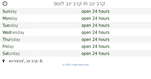
Сонол
Giv'at Shmuel
Gas station
read more
2.655 km
תחנת דלק סונול
גבעת שמואל
Gas station
read more
2.813 km
Паз
Derech Yitshak Rabin, Petah Tikva
Gas station
read more
2.813 km
פז נוה עוז
דרך יצחק רבין, פתח תקווה
Gas station
read more
2.909 km
דור אלון רחוב הסיבים
פתח תקווה
Gas station
read more
2.909 km
הסיבים
Petah Tikva
Gas station
read more
3.166 km
מפגש השרון
פתח תקווה
Gas station
read more
3.413 km
פז פתח תקווה עיר
רח' זאב ז'בוטינסקי 6, פתח תקווה
Gas station
read more
3.671 km
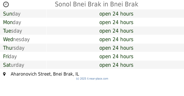
Sonol Bnei Brak
Aharonovich Street, Bnei Brak
Gas station
read more
3.671 km
סונול בני ברק
אהרונוביץ', בני ברק
Gas station
read more
3.673 km
תחנת דלק סונול רימונים
Aharonovich Street 12, Bnei Brak
Gas station
read more
4.088 km
Dor Alon
כביש 4 פינת כביש 461
Gas station
read more
4.088 km
Dor Alon
כביש 4
Gas station
read more
📑
all categories
Accounting
Administrative area level 1
Administrative area level 2
Airport
Amusement park
Aquarium
Art gallery
Atm
Bakery
Bank
Bar
Beauty salon
Bicycle store
Book store
Bowling alley
Bus station
Cafe
Campground
Car dealer
Car rental
Car repair
Car wash
Casino
Cemetery
Church
City hall
Clothing store
Colloquial area
Convenience store
Country
Courthouse
Dentist
Department store
Doctor
Electrician
Electronics store
Embassy
Establishment
Finance
Fire station
Florist
Food
Funeral home
Furniture store
Gas station
General contractor
Grocery or supermarket
Gym
Hair care
Hardware store
Health
Hindu Temple
Home goods store
Hospital
Insurance agency
Intersection
Jewelry store
Laundry
Lawyer
Library
Light rail station
Liquor store
Local government office
Locality
Locksmith
Lodging
Meal delivery
Meal takeaway
Mosque
Movie rental
Movie theater
Moving company
Museum
Natural feature
Neighborhood
Night club
Painter
Park
Parking
Pet store
Pharmacy
Physiotherapist
Place of worship
Plumber
Point of interest
Police
Political
Post office
Premise
Real estate agency
Restaurant
Roofing contractor
Route
Rv park, camping
School
Shoe store
Shopping mall
Spa
Stadium
Storage
Store
Subpremise
Subway station
Supermarket
Synagogue
Taxi stand
Train station
Transit station
Travel agency
University
Veterinary care
Zoo
administrative area level 3
administrative area level 4
sublocality level 1
↑