Gas station nearby Paz Carmi
Israel
Gas station nearby Paz Carmi
Paz Carmi
Derech Metsada, Beersheba, Be'er Sheva, IL Израиль
contacts phone
:
+972 1-800-774-774
website:
www.paz.co.il
Latitude:
31.258604
, Longitude:
34.796058
larger map & directions
read more
nearest Gas station
פז כרמי
דרך מצדה, באר שבע
Gas station
read more
944 m
תחנת דלק אשל אברהם
אברהם אבינו 36, באר שבע
Gas station
read more
944 m
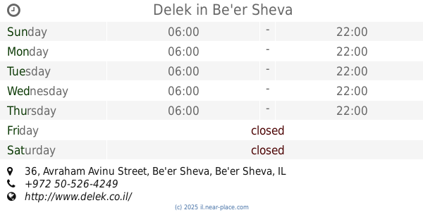
Delek
Avraham Avinu Street 36, Be'er Sheva
Gas station
read more
1.172 km
פז אצטדיון בש
דרך שמשון, באר שבע
Gas station
read more
1.172 km
Paz
Derech Shimshon, Be'er Sheva
Gas station
read more
1.47 km
Paz Area Government Complex Center Beersheba
דרך פועלי בניין 8, באר שבע
Gas station
read more
1.482 km
Paz
שדרות שז"ר, Be'er Sheva
Gas station
read more
1.482 km
פז קרית הממשלה
שדרות שז"ר, באר שבע
Gas station
read more
1.634 km
דלק נווה צאלים
באר שבע
Gas station
read more
1.697 km
Dor Alon
Yehoshu'a ha-Tsoref Street 4, Be'er Sheva
Gas station
read more
1.766 km
Gas station patrol
Be'er Sheva
Gas station
read more
1.766 km
פטרול תחנת דלק
באר שבע
Gas station
read more
2.01 km
סדש-טוביהו
Be'er Sheva
Gas station
read more
2.01 km
סדש-טוביהו
באר שבע
Gas station
read more
2.026 km
Paz Be'er Sheva North
Sderot Yerushalayim, Be'er Sheva
Gas station
read more
2.026 km
Paz
Sderot Yerushalayim, Be'er Sheva
Gas station
read more
2.034 km
ממתחם פז סנטר באר שבע צפון
שדרות ירושלים 4, באר שבע
Gas station
read more
2.034 km
ממתחם פז סנטר באר שבע צפון
Sderot Yerushalayim 4, Be'er Sheva
Gas station
read more
2.075 km
תחנת דלק סונול
פינת, דרך חברון, באר שבע
Gas station
read more
2.075 km
Сонол
פינת, Derekh Hebron, Be'er Sheva
Gas station
read more
2.077 km
דרך חברון
באר שבע
Gas station
read more
2.077 km
Derekh Khevron
Be'er Sheva
Gas station
read more
2.08 km
תחנת דלק פטרול
באר שבע
Gas station
read more
2.101 km
דלק שיכון עובדים
Derekh Hebron 21, Be'er Sheva
Gas station
read more
2.106 km
שיכון עובדים
באר שבע
Gas station
read more
📑
all categories
Accounting
Administrative area level 1
Administrative area level 2
Airport
Amusement park
Aquarium
Art gallery
Atm
Bakery
Bank
Bar
Beauty salon
Bicycle store
Book store
Bowling alley
Bus station
Cafe
Campground
Car dealer
Car rental
Car repair
Car wash
Casino
Cemetery
Church
City hall
Clothing store
Colloquial area
Convenience store
Country
Courthouse
Dentist
Department store
Doctor
Electrician
Electronics store
Embassy
Establishment
Finance
Fire station
Florist
Food
Funeral home
Furniture store
Gas station
General contractor
Grocery or supermarket
Gym
Hair care
Hardware store
Health
Hindu Temple
Home goods store
Hospital
Insurance agency
Intersection
Jewelry store
Laundry
Lawyer
Library
Light rail station
Liquor store
Local government office
Locality
Locksmith
Lodging
Meal delivery
Meal takeaway
Mosque
Movie rental
Movie theater
Moving company
Museum
Natural feature
Neighborhood
Night club
Painter
Park
Parking
Pet store
Pharmacy
Physiotherapist
Place of worship
Plumber
Point of interest
Police
Political
Post office
Premise
Real estate agency
Restaurant
Roofing contractor
Route
Rv park, camping
School
Shoe store
Shopping mall
Spa
Stadium
Storage
Store
Subpremise
Subway station
Supermarket
Synagogue
Taxi stand
Train station
Transit station
Travel agency
University
Veterinary care
Zoo
administrative area level 3
administrative area level 4
sublocality level 1
↑