Gas station nearby Merkaz Tsvi
Israel
Gas station nearby Merkaz Tsvi
Merkaz Tsvi
Kirjat Szemona, Izrael
contacts phone
:
+972
Latitude:
33.211444
, Longitude:
35.569257
larger map & directions
read more
nearest Gas station
945 m
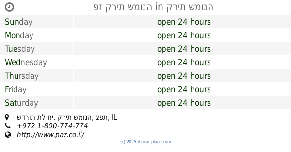
פז קרית שמונה
שדרות תל חי, קרית שמונה
Gas station
read more
945 m
Paz Kiryat Shmona
שדרות תל חי, קרית שמונה
Gas station
read more
1.657 km
תחנת דלק טן
Qiryat Shemona
Gas station
read more
1.676 km
תחנת דלק בל
קרית שמונה
Gas station
read more
1.676 km
Bell Gas Station
Qiryat Shemona
Gas station
read more
2.07 km
סונול גליל עליון
קרית שמונה
Gas station
read more
2.07 km
Сонол
Qiryat Shemona
Gas station
read more
2.07 km
Sonol Galil Elyon
Qiryat Shemona
Gas station
read more
2.358 km
Margaliyot
Margaliot
Gas station
read more
4.54 km
דור אלון
כביש 99
Gas station
read more
4.595 km
Gome Junction
Israel
Gas station
read more
4.595 km
צומת הגומא
Israel
Gas station
read more
5.612 km
תחנת דלק פז
כפר בלום
Gas station
read more
7.756 km
Jammu Kashmir Bank
Hakura Street, Metula
Gas station
read more
8.021 km
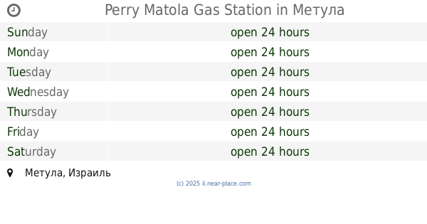
Perry Matola Gas Station
Metula
Gas station
read more
8.39 km
תחנת דלק פז כפר סאלד
כפר סאלד
Gas station
read more
9.651 km
Paz Tsomet Ko'akh
כביש 90, קרית שמונה
Gas station
read more
9.651 km
Paz Tsomet Ko'akh
כביש 90 פינת כביש 899, קרית שמונה
Gas station
read more
9.651 km
פז צומת כח
כביש 90 פינת כביש 899, קרית שמונה
Gas station
read more
11.933 km
Gonen
Gonen
Gas station
read more
17.503 km
Mas'ada
Mas'ada
Gas station
read more
18.813 km
תחנת דלק מלאק
מג'דל
Gas station
read more
18.844 km
Sonol gas station
Majdal Shams
Gas station
read more
19.47 km
Fuel Trac Majdal Shams
כביש 98, מג'דל א-שמס
Gas station
read more
29.709 km
Sonol Horfesh
כפר חורפיש
Gas station
read more
📑
all categories
Accounting
Administrative area level 1
Administrative area level 2
Airport
Amusement park
Aquarium
Art gallery
Atm
Bakery
Bank
Bar
Beauty salon
Bicycle store
Book store
Bowling alley
Bus station
Cafe
Campground
Car dealer
Car rental
Car repair
Car wash
Casino
Cemetery
Church
City hall
Clothing store
Colloquial area
Convenience store
Country
Courthouse
Dentist
Department store
Doctor
Electrician
Electronics store
Embassy
Establishment
Finance
Fire station
Florist
Food
Funeral home
Furniture store
Gas station
General contractor
Grocery or supermarket
Gym
Hair care
Hardware store
Health
Hindu Temple
Home goods store
Hospital
Insurance agency
Intersection
Jewelry store
Laundry
Lawyer
Library
Light rail station
Liquor store
Local government office
Locality
Locksmith
Lodging
Meal delivery
Meal takeaway
Mosque
Movie rental
Movie theater
Moving company
Museum
Natural feature
Neighborhood
Night club
Painter
Park
Parking
Pet store
Pharmacy
Physiotherapist
Place of worship
Plumber
Point of interest
Police
Political
Post office
Premise
Real estate agency
Restaurant
Roofing contractor
Route
Rv park, camping
School
Shoe store
Shopping mall
Spa
Stadium
Storage
Store
Subpremise
Subway station
Supermarket
Synagogue
Taxi stand
Train station
Transit station
Travel agency
University
Veterinary care
Zoo
administrative area level 3
administrative area level 4
sublocality level 1
↑