Gas station nearby דלק
Israel
Gas station nearby דלק
דלק
Meron, Израиль
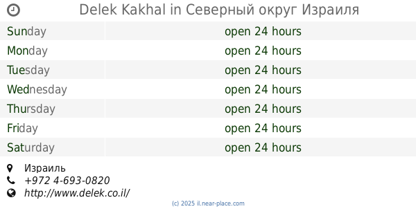
contacts phone
:
+972
Latitude:
32.9878061
, Longitude:
35.442432
larger map & directions
read more
nearest Gas station
3.318 km
מתחם פז סנטר גוש חלב
כביש 89, Jish
Gas station
read more
3.329 km
פז גוש חלב
כביש צפת מעלות, ג'יש
Gas station
read more
4.942 km
דלק בעיר
Derech HaShokolad 18, Safed
Gas station
read more
4.942 km
דלק בעיר
דרך השוקולד 18, צפת
Gas station
read more
5.06 km
Meitav
Safed
Gas station
read more
6.126 km
תחנת דלק סונול
חיים וייצמן 22, צפת
Gas station
read more
6.145 km
Delek
Ha-Gdud ha-Shlishi Street 1, Safed
Gas station
read more
6.657 km
תחנת תדלוק אלתופיק
Unnamed Road, Beit Jann
Gas station
read more
7.383 km
בית ג'ן סונורית
Israel
Gas station
read more
10.204 km
Delek Rosh Pina
Rosh Pinna
Gas station
read more
10.204 km
דלק ראש פינה
ראש פינה
Gas station
read more
10.211 km
פז
דרך הגליל, ראש פינה
Gas station
read more
10.223 km
North Star
Rosh Pinna
Gas station
read more
10.722 km
דלק חצור הגלילית
מעלה חוני המעגל, חצור הגלילית
Gas station
read more
11.89 km
Delek Kakhal
Israel
Gas station
read more
13.04 km
Limon Fuel
נחף
Gas station
read more
14.009 km
מוסך שחר כרמיאל מורשה אופל
Ha-Ofan Street 17, Karmiel
Gas station
read more
14.111 km
Gas station patrol
Nahf
Gas station
read more
14.457 km
דור אלון
א.ת. כרמיאל, החרושת, כרמיאל
Gas station
read more
14.519 km
צלמון
מע'אר
Gas station
read more
15.88 km
Сонол
Deir Hanna
Gas station
read more
16.685 km
פז כרמיאל מערב
דרור, כרמיאל
Gas station
read more
17.788 km
סנולו עראבה
עראבה
Gas station
read more
17.807 km
פרג'
Arraba
Gas station
read more
19.941 km
יעד סכנין
Sakhnin
Gas station
read more
📑
all categories
Accounting
Administrative area level 1
Administrative area level 2
Airport
Amusement park
Aquarium
Art gallery
Atm
Bakery
Bank
Bar
Beauty salon
Bicycle store
Book store
Bowling alley
Bus station
Cafe
Campground
Car dealer
Car rental
Car repair
Car wash
Casino
Cemetery
Church
City hall
Clothing store
Colloquial area
Convenience store
Country
Courthouse
Dentist
Department store
Doctor
Electrician
Electronics store
Embassy
Establishment
Finance
Fire station
Florist
Food
Funeral home
Furniture store
Gas station
General contractor
Grocery or supermarket
Gym
Hair care
Hardware store
Health
Hindu Temple
Home goods store
Hospital
Insurance agency
Intersection
Jewelry store
Laundry
Lawyer
Library
Light rail station
Liquor store
Local government office
Locality
Locksmith
Lodging
Meal delivery
Meal takeaway
Mosque
Movie rental
Movie theater
Moving company
Museum
Natural feature
Neighborhood
Night club
Painter
Park
Parking
Pet store
Pharmacy
Physiotherapist
Place of worship
Plumber
Point of interest
Police
Political
Post office
Premise
Real estate agency
Restaurant
Roofing contractor
Route
Rv park, camping
School
Shoe store
Shopping mall
Spa
Stadium
Storage
Store
Subpremise
Subway station
Supermarket
Synagogue
Taxi stand
Train station
Transit station
Travel agency
University
Veterinary care
Zoo
administrative area level 3
administrative area level 4
sublocality level 1
↑