Gas station nearby Delek
Israel
Gas station nearby Delek
Delek
Yad Binyamin, Израиль
contacts phone
:
+972 8-869-6860
website:
www.delek.co.il
Latitude:
31.7923886
, Longitude:
34.824176
larger map & directions
read more
nearest Gas station
Delek Menta
Yad Binyamin
Gas station
read more
3.966 km
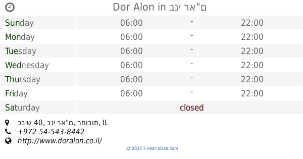
Dor Alon
כביש 3, יסודות
Gas station
read more
3.966 km
תחנת דלק דור אלון יסודות
כביש 3, יסודות
Gas station
read more
4.047 km
Paz Gedera
Sderot Menachem Begin, Gedera
Gas station
read more
4.643 km
Dor Alon
כביש 40, בני רא"ם
Gas station
read more
4.782 km
Re'em
Israel
Gas station
read more
5.021 km
מתחם פז סנטר צומת ראם
כביש 40, בני רא"ם
Gas station
read more
5.021 km
Paz compound Ram junction Center
כביש 40, Bnei Re'em
Gas station
read more
5.103 km
פז צומת ראם
צומת ראם, קרית מלאכי
Gas station
read more
5.103 km
פז צומת ראם
צומת ראם, Kiryat Malakhi
Gas station
read more
5.177 km
צמיגי חיים אוזן
מסמיה אזור מלאכי
Gas station
read more
5.387 km
דלק
Israel
Gas station
read more
5.597 km
תחנת דלק סונול הבילויים, גדרה
Herzl Street, Gedera
Gas station
read more
5.597 km
Сонол
Herzl Street, Gedera
Gas station
read more
5.649 km
Ha-Arba'a
Gedera
Gas station
read more
5.943 km
פז ברורים
צומת מסמיה, Kiryat Malakhi
Gas station
read more
5.949 km
ברורים
Israel
Gas station
read more
5.949 km
Brurim
Israel
Gas station
read more
10.44 km
סדש תימורים
Timorim
Gas station
read more
10.72 km
תחנת דלק טן
באר טוביה, Asif Street
Gas station
read more
11.402 km
פז רכטמן רחובות
א"ת רכטמן, קלמן גבריאלוב פינת היצירה, רחובות
Gas station
read more
13.825 km
הקידמה
אשדוד
Gas station
read more
13.921 km
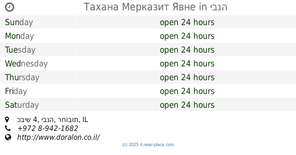
Тахана Мерказит Явне
כביש 4, יבנה
Gas station
read more
13.953 km
תחנת דלק דור אלון
יציאה מתחנת דלק, גן יבנה
Gas station
read more
15.227 km
תפוז
Odem Street, Ashdod
Gas station
read more
📑
all categories
Accounting
Administrative area level 1
Administrative area level 2
Airport
Amusement park
Aquarium
Art gallery
Atm
Bakery
Bank
Bar
Beauty salon
Bicycle store
Book store
Bowling alley
Bus station
Cafe
Campground
Car dealer
Car rental
Car repair
Car wash
Casino
Cemetery
Church
City hall
Clothing store
Colloquial area
Convenience store
Country
Courthouse
Dentist
Department store
Doctor
Electrician
Electronics store
Embassy
Establishment
Finance
Fire station
Florist
Food
Funeral home
Furniture store
Gas station
General contractor
Grocery or supermarket
Gym
Hair care
Hardware store
Health
Hindu Temple
Home goods store
Hospital
Insurance agency
Intersection
Jewelry store
Laundry
Lawyer
Library
Light rail station
Liquor store
Local government office
Locality
Locksmith
Lodging
Meal delivery
Meal takeaway
Mosque
Movie rental
Movie theater
Moving company
Museum
Natural feature
Neighborhood
Night club
Painter
Park
Parking
Pet store
Pharmacy
Physiotherapist
Place of worship
Plumber
Point of interest
Police
Political
Post office
Premise
Real estate agency
Restaurant
Roofing contractor
Route
Rv park, camping
School
Shoe store
Shopping mall
Spa
Stadium
Storage
Store
Subpremise
Subway station
Supermarket
Synagogue
Taxi stand
Train station
Transit station
Travel agency
University
Veterinary care
Zoo
administrative area level 3
administrative area level 4
sublocality level 1
↑