Establishment nearby سوبر ماركت مناع
Israel
Establishment nearby سوبر ماركت مناع
سوبر ماركت مناع
العامودي, غزة
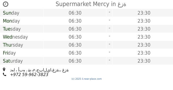
contacts phone
:
+972
Latitude:
31.5509581
, Longitude:
34.4768318
larger map & directions
read more
nearest Establishment
426 m
النجوم ماركت
HF2J+FG8, Beit Lahia
Supermarket
Grocery or supermarket
Store
Point of interest
Food
Establishment
read more
578 m
Khraba House
GFWH+9CJ، غزة
Cafe
Store
Food
Point of interest
Establishment
read more
648 m
العمدة ماركت ALOMDA MARKET
مدرسة عثمان بن عفان الثانوية، شمال غزة - بجوار
Supermarket
Grocery or supermarket
Store
Food
Point of interest
Establishment
read more
759 m
سوبر ماركت العسلي
HF39+5MV, Gaza
Supermarket
Grocery or supermarket
Food
Store
Point of interest
Establishment
read more
819 m
سوبر ماركت الدعدور
شارع التوام حي 17, Ghazzah
Supermarket
Grocery or supermarket
Food
Store
Point of interest
Establishment
read more
911 m
سوبر ماركت ابو حمزة
GFVH+5C9, Jabalia
Supermarket
Grocery or supermarket
Food
Store
Point of interest
Establishment
read more
942 m
Ahmed El-Mudallal Home
Ali Altanany str, Gaza
Lodging
Point of interest
Establishment
read more
1.092 km
مستشفى الكرامة التخصصي
امتداد شارع الكرامة، مقابل برج الاندلس, غزة
Hospital
Health
Point of interest
Establishment
read more
1.129 km
كشك المليون
GFV8+VXM, Jabalia
Cafe
Food
Point of interest
Store
Establishment
read more
1.218 km
كشك لؤي
Cafe
Food
Point of interest
Establishment
read more
1.427 km
ميني ماركت الهندي
GFRP+FJ2, Gaza
Supermarket
Grocery or supermarket
Point of interest
Store
Food
Establishment
read more
1.458 km
الصالة الذهبية
بحر بيت لاهيا، الواحة، بجوار المدرسه الامريكيه، بيت لاهيا, Ghazzah
Lodging
Point of interest
Establishment
read more
1.504 km
شاليه الكوخ الأزرق
Lodging
Point of interest
Establishment
read more
1.806 km
سنتر زقوت
GFQ7+R8C, شارع الشفاء, Hafar Al Batin
Supermarket
Grocery or supermarket
Store
Food
Point of interest
Establishment
read more
1.85 km
سوبر ماركت ريان
GFXW+7CG, Beit Lahia
Supermarket
Grocery or supermarket
Food
Point of interest
Store
Establishment
read more
1.874 km
سوبر ماركت علي الأشقر
Supermarket
Grocery or supermarket
Point of interest
Store
Food
Establishment
read more
1.889 km
سوبر ماركت وطني
GFPP+76H, نزلة،, Jabalia
Supermarket
Grocery or supermarket
Store
Food
Point of interest
Establishment
read more
1.975 km
سوبر ماركت حمودة
GFM9+PR9, شارع فلسطين, غزة
Supermarket
Grocery or supermarket
Food
Store
Point of interest
Establishment
read more
1.991 km
عيادة د. ثائر ابو عيده
صاله الاورينت، غزة الفالوجا خلف
Dentist
Health
Point of interest
Establishment
read more
2.003 km
Supermarket Mercy
دوار أبو شرخ،جباليا،غزة،، غزة
Supermarket
Grocery or supermarket
Store
Point of interest
Food
Establishment
read more
2.203 km
ATM Bank of Palestine
GFP6+FH6, El-Nasr, Giza
Atm
Finance
Point of interest
Establishment
read more
2.237 km
الجبل للمعاملات البنكية والاجهزة الكهربائية
غزة, الشيخ رضوان،, Ghazzah
Bank
Point of interest
Finance
Establishment
read more
2.349 km
Bank of jordan
Alnaseer street
Bank
Finance
Point of interest
Establishment
read more
2.443 km
مستشفى العيون الحكومى
GFM5+VQW, تقاطع شارع النصر مع Abu Dhabi - Al Ain Road, Ghazzah
Hospital
Health
Point of interest
Establishment
read more
2.612 km
Victory Children's Hospital
GFM5+7GF, Mohammed Kandeel, Giza
Hospital
Point of interest
Health
Establishment
read more
📑
all categories
Accounting
Administrative area level 1
Administrative area level 2
Airport
Amusement park
Aquarium
Art gallery
Atm
Bakery
Bank
Bar
Beauty salon
Bicycle store
Book store
Bowling alley
Bus station
Cafe
Campground
Car dealer
Car rental
Car repair
Car wash
Casino
Cemetery
Church
City hall
Clothing store
Colloquial area
Convenience store
Country
Courthouse
Dentist
Department store
Doctor
Electrician
Electronics store
Embassy
Establishment
Finance
Fire station
Florist
Food
Funeral home
Furniture store
Gas station
General contractor
Grocery or supermarket
Gym
Hair care
Hardware store
Health
Hindu Temple
Home goods store
Hospital
Insurance agency
Intersection
Jewelry store
Laundry
Lawyer
Library
Light rail station
Liquor store
Local government office
Locality
Locksmith
Lodging
Meal delivery
Meal takeaway
Mosque
Movie rental
Movie theater
Moving company
Museum
Natural feature
Neighborhood
Night club
Painter
Park
Parking
Pet store
Pharmacy
Physiotherapist
Place of worship
Plumber
Point of interest
Police
Political
Post office
Premise
Real estate agency
Restaurant
Roofing contractor
Route
Rv park, camping
School
Shoe store
Shopping mall
Spa
Stadium
Storage
Store
Subpremise
Subway station
Supermarket
Synagogue
Taxi stand
Train station
Transit station
Travel agency
University
Veterinary care
Zoo
administrative area level 3
administrative area level 4
sublocality level 1
↑