Establishment nearby Sam's Bagels
Israel
Establishment nearby Sam's Bagels
Sam's Bagels
11, Ben Yehuda Street, Jerusalem, IL Israel
contacts phone
:
+972 2-625-3454
website:
sambagels.co.il
Latitude:
31.7815312
, Longitude:
35.2178476
larger map & directions
read more
nearest Establishment
106 m
Super Market
Shamai Street 12, Jerusalem
Supermarket
Grocery or supermarket
Food
Point of interest
Store
Establishment
read more
124 m
סופר שמאי
Shamai Street 12, Jerusalem
Supermarket
Grocery or supermarket
Food
Point of interest
Store
Establishment
read more
151 m
Bank Hapoalim
המלך ג`ורג` 16, Jerusalem
Bank
Finance
Point of interest
Establishment
read more
195 m
Iwo's Meatburger
Hillel Street 24, Jerusalem
Restaurant
Food
Point of interest
Establishment
read more
201 m
Bank Leumi
King George Street 22, Jerusalem
Bank
Finance
Point of interest
Establishment
read more
271 m
ביח ביקור חולים
Bikur Cholim Hospital, Natan Strauss Street 5, Jerusalem
Hospital
Health
Point of interest
Establishment
read more
288 m
בית חולים בקור חולים
Natan Strauss Street 5, Jerusalem
Hospital
Health
Point of interest
Establishment
read more
381 m
Coffee Nadi
מעונות הסטודנטים, הלל 39, ירושלים
Cafe
Food
Point of interest
Store
Establishment
read more
423 m
M.S.G Medical Service General LTD שירותי רפואה כלליים
Yisha'ayahu Street 6, Jerusalem
Hospital
Point of interest
Doctor
Health
Establishment
read more
432 m
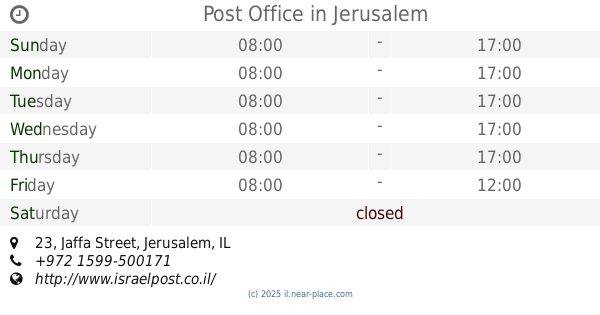
Post Office
Jaffa Street 23, Jerusalem
Post office
Finance
Point of interest
Establishment
read more
469 m
קריוסייב
Natan Strauss Street, Jerusalem
Hospital
Health
Point of interest
Establishment
read more
569 m
Cheese & Tomato Pizza
King George Street 52, Jerusalem
Meal delivery
Meal takeaway
Restaurant
Food
Point of interest
Establishment
read more
581 m
דר הזה חנוך
Koresh Street 12, Jerusalem
Dentist
Health
Point of interest
Establishment
read more
598 m
בית החתן המת
Jaffa Street 86, Jerusalem
Hospital
Health
Point of interest
Establishment
read more
624 m
יפו צ'יינג' - Yafo Change (Western Union)
Jaffa Street 17, Jerusalem
Atm
Finance
Point of interest
Establishment
read more
645 m
שלי ירושלים- אגרון
Gershon Agron Street 1, Jerusalem
Supermarket
Grocery or supermarket
Food
Point of interest
Store
Establishment
read more
677 m
Azura
Ha-Eshkol Street 4, Jerusalem
Restaurant
Food
Point of interest
Establishment
read more
685 m
David Citadel Hotel
King David Street 7, Jerusalem
Lodging
Point of interest
Establishment
read more
785 m
Notre Dame of Jerusalem Center
HaTsanhanim Street 3, Jerusalem
Lodging
Point of interest
Establishment
read more
829 m
Mizrahi-Tefahot
Agripas Street 88, Jerusalem
Bank
Finance
Point of interest
Establishment
read more
851 m
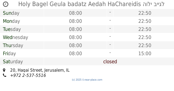
Holy Bagel Geula badatz Aedah HaChareidis הולי בייגל אנג׳ל גאולה העדה החרדית
Hagai Street 20, Jerusalem
Bakery
Meal takeaway
Cafe
Restaurant
Food
Point of interest
Store
Establishment
read more
962 m
Co-op Shop
קניונית וולפסון, Diskin 9 א, Jerusalem
Supermarket
Grocery or supermarket
Food
Point of interest
Store
Establishment
read more
963 m
Jerusalem Medical Center
מרכז וולפסון, Diskin 9 א, Jerusalem
Hospital
Health
Point of interest
Establishment
read more
1.014 km
Nafoura Restaurant
Latin Patriarchate Road 26, Jerusalem
Restaurant
Food
Point of interest
Establishment
read more
1.181 km
Leonardo Jerusalem Hotel
Saint George Street 9, Jerusalem
Lodging
Point of interest
Establishment
read more
📑
all categories
Accounting
Administrative area level 1
Administrative area level 2
Airport
Amusement park
Aquarium
Art gallery
Atm
Bakery
Bank
Bar
Beauty salon
Bicycle store
Book store
Bowling alley
Bus station
Cafe
Campground
Car dealer
Car rental
Car repair
Car wash
Casino
Cemetery
Church
City hall
Clothing store
Colloquial area
Convenience store
Country
Courthouse
Dentist
Department store
Doctor
Electrician
Electronics store
Embassy
Establishment
Finance
Fire station
Florist
Food
Funeral home
Furniture store
Gas station
General contractor
Grocery or supermarket
Gym
Hair care
Hardware store
Health
Hindu Temple
Home goods store
Hospital
Insurance agency
Intersection
Jewelry store
Laundry
Lawyer
Library
Light rail station
Liquor store
Local government office
Locality
Locksmith
Lodging
Meal delivery
Meal takeaway
Mosque
Movie rental
Movie theater
Moving company
Museum
Natural feature
Neighborhood
Night club
Painter
Park
Parking
Pet store
Pharmacy
Physiotherapist
Place of worship
Plumber
Point of interest
Police
Political
Post office
Premise
Real estate agency
Restaurant
Roofing contractor
Route
Rv park, camping
School
Shoe store
Shopping mall
Spa
Stadium
Storage
Store
Subpremise
Subway station
Supermarket
Synagogue
Taxi stand
Train station
Transit station
Travel agency
University
Veterinary care
Zoo
administrative area level 3
administrative area level 4
sublocality level 1
↑