Convenience store nearby מילה מרקט
Israel
Convenience store nearby מילה מרקט
מילה מרקט
10, HaZamir Street, Netanya, HaSharon, IL Израиль
contacts phone
:
+972 54-680-3194
Latitude:
32.3042308
, Longitude:
34.882445
larger map & directions
read more
nearest Convenience store
1.398 km
הבית לטכנאי המקצועי
HaMerkava Street 5, Netanya
Convenience store
read more
1.398 km
הבית לטכנאי המקצועי
המרכבה 5, נתניה
Convenience store
read more
1.897 km
אלונית נורדיה
Nordia
Convenience store
read more
2.994 km
מינימרקט שמעון
Na'aman Belkind Street 7, Netanya
Convenience store
read more
3.451 km
City Corner
Herzl Street 38, Netanya
Convenience store
read more
3.607 km
צרכניית האחים אבו
Herzl Street 10, Kadima Zoran
Convenience store
read more
3.817 km
פיצוחי סאקיזדה
Herzl Street 14, Netanya
Convenience store
read more
3.86 km
Grocery Georgian
Netanya
Convenience store
read more
3.91 km
Minimarket 24
Dizengoff Street 27, Netanya
Convenience store
read more
4.83 km
Amrm's Grasari
Ovadya mi-Bartenura Street 1-3, Netanya
Convenience store
read more
4.83 km
עמרמ'ס גראסערי
עובדיה מברטנורא 1-3, נתניה
Convenience store
read more
5.769 km
Grocery Kfar Monash
Kfar Monash
Convenience store
read more
5.769 km
מכולת כפר מונאש
כפר מונש
Convenience store
read more
6.937 km
קואופ שופ
Porat
Convenience store
read more
6.937 km
קואופ שופ
פורת
Convenience store
read more
7.273 km
כלבו
Yakum
Convenience store
read more
8.985 km
Yellow
Israel
Convenience store
read more
13.613 km
אלונית במושב
אחיטוב
Convenience store
read more
13.753 km
קיוסק בדקה ה-90
118, אחוזה, רעננה
Convenience store
read more
14.055 km
סופר חי גני השרון
Duchifat Street 5, Kefar Sava
Supermarket
Department store
Convenience store
Grocery or supermarket
Food
Point of interest
Store
Establishment
read more
14.478 km
מכולת נוף ים
Herzliya
Convenience store
read more
14.754 km
הצומת של אריק
ויצמן 172, כפר סבא
Convenience store
read more
14.785 km
מכולת אדרי חנה
Mivtsa Ezra Street 24, Hadera
Convenience store
read more
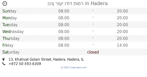
15.087 km
כהן רועי ודוד תומר
Khativat Golani Street 13, Hadera
Convenience store
read more
15.728 km
Jr. Too much Olympics square
Ramat Yam Street, Herzliya
Convenience store
read more
📑
all categories
Accounting
Administrative area level 1
Administrative area level 2
Airport
Amusement park
Aquarium
Art gallery
Atm
Bakery
Bank
Bar
Beauty salon
Bicycle store
Book store
Bowling alley
Bus station
Cafe
Campground
Car dealer
Car rental
Car repair
Car wash
Casino
Cemetery
Church
City hall
Clothing store
Colloquial area
Convenience store
Country
Courthouse
Dentist
Department store
Doctor
Electrician
Electronics store
Embassy
Establishment
Finance
Fire station
Florist
Food
Funeral home
Furniture store
Gas station
General contractor
Grocery or supermarket
Gym
Hair care
Hardware store
Health
Hindu Temple
Home goods store
Hospital
Insurance agency
Intersection
Jewelry store
Laundry
Lawyer
Library
Light rail station
Liquor store
Local government office
Locality
Locksmith
Lodging
Meal delivery
Meal takeaway
Mosque
Movie rental
Movie theater
Moving company
Museum
Natural feature
Neighborhood
Night club
Painter
Park
Parking
Pet store
Pharmacy
Physiotherapist
Place of worship
Plumber
Point of interest
Police
Political
Post office
Premise
Real estate agency
Restaurant
Roofing contractor
Route
Rv park, camping
School
Shoe store
Shopping mall
Spa
Stadium
Storage
Store
Subpremise
Subway station
Supermarket
Synagogue
Taxi stand
Train station
Transit station
Travel agency
University
Veterinary care
Zoo
administrative area level 3
administrative area level 4
sublocality level 1
↑