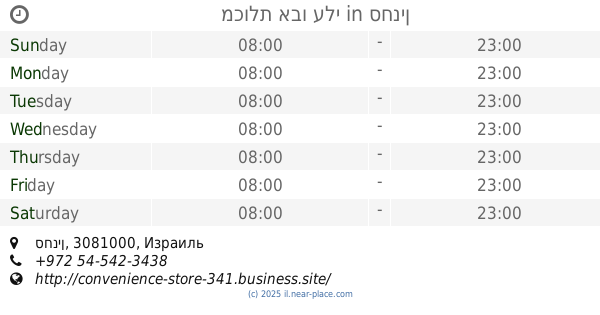
Convenience store nearby מרכולית
Israel
Convenience store nearby מרכולית
מרכולית
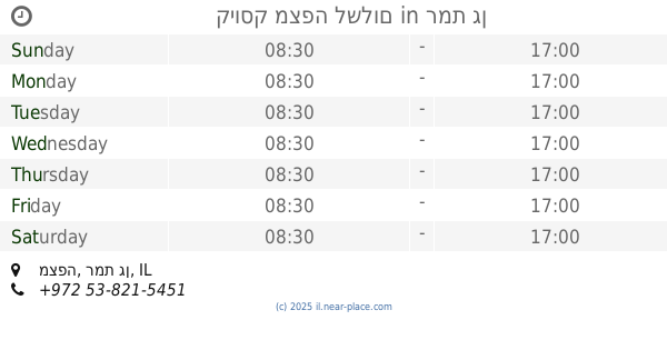
Gonen, Израиль
contacts phone
:
+972
Latitude:
33.1233856
, Longitude:
35.6469595
larger map & directions
read more
nearest Convenience store
מרכולית
גונן
Convenience store
read more
10.126 km
Grocery Store
Beit Hillel
Convenience store
read more
10.126 km
Grocery Store
בית הלל
Convenience store
read more
22.57 km
כל בו רביד
בנין לב העיר א.ת. ישן, Safed
Convenience store
read more
22.57 km
כל בו רביד
בנין לב העיר א.ת. ישן, צפת
Convenience store
read more
27.413 km
צרכניית אמירים
Ha-Rimonim Street 142, Amirim
Convenience store
read more
30.717 km
מרכז קניות גאנם
עין אל-אסד
Convenience store
read more
34.213 km
מינימרקט המושבה
Ha-Meyasdim Street 1, Migdal
Convenience store
read more
34.486 km
צרכנייה
רמת הגולן, Ramat Magshimim
Convenience store
read more
38.916 km
D & M convenience store
HaGalil Street 54, Tiberias
Convenience store
read more
40.257 km
אטליז אנטריקוט קצבים בשר טרי
Ha-Nasi Weizman Street 28, Tiberias
Convenience store
read more
40.599 km
קיוסק מצפה לשלום
מצפה, רמת גן
Convenience store
read more
40.599 km
Snack expect peace
Mitspe Street, Ramat Gan
Convenience store
read more
40.792 km
Tik Tak
Sderot Nesi'ei Israel 102-104, Karmiel
Convenience store
read more
44.193 km
Grocery Store
Yuvalim
Convenience store
read more
44.228 km
Grocery Store
חניתה
Convenience store
read more
44.254 km
מכולת אבו עלי
סחנין
Convenience store
read more
46.642 km
Grocery Menashe
Derech HaDror, Atzmon
Convenience store
read more
49.73 km
Grocery Store
Rosh HaNikra
Convenience store
read more
56.786 km
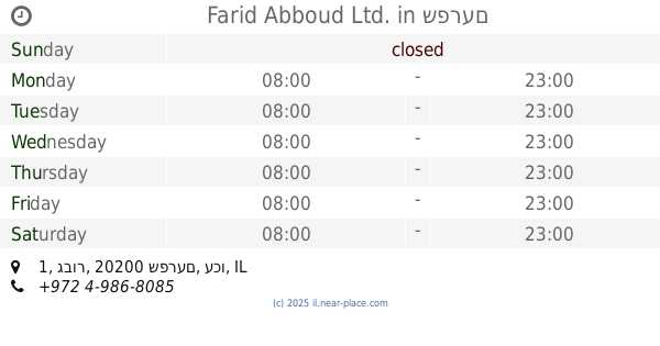
Farid Abboud Ltd.
גבור 1, שפרעם
Convenience store
read more
59.5 km
מכולת אורגנית הרדוף
הרדוף
Convenience store
read more
60.438 km
צרכניית בית לחם הגלילית
12, Beit Lehem HaGlilit
Supermarket
Convenience store
Grocery or supermarket
Food
Store
Point of interest
Establishment
read more
62.882 km
מכולת זובידאת גמילה
El Zaur Street 70, Basmat Tab'un
Convenience store
read more
62.882 km
מכולת זובידאת גמילה
אל זהור 70, בסמת טבעון
Convenience store
read more
66.905 km
Grocery Store
שער העמקים
Convenience store
read more
📑
all categories
Accounting
Administrative area level 1
Administrative area level 2
Airport
Amusement park
Aquarium
Art gallery
Atm
Bakery
Bank
Bar
Beauty salon
Bicycle store
Book store
Bowling alley
Bus station
Cafe
Campground
Car dealer
Car rental
Car repair
Car wash
Casino
Cemetery
Church
City hall
Clothing store
Colloquial area
Convenience store
Country
Courthouse
Dentist
Department store
Doctor
Electrician
Electronics store
Embassy
Establishment
Finance
Fire station
Florist
Food
Funeral home
Furniture store
Gas station
General contractor
Grocery or supermarket
Gym
Hair care
Hardware store
Health
Hindu Temple
Home goods store
Hospital
Insurance agency
Intersection
Jewelry store
Laundry
Lawyer
Library
Light rail station
Liquor store
Local government office
Locality
Locksmith
Lodging
Meal delivery
Meal takeaway
Mosque
Movie rental
Movie theater
Moving company
Museum
Natural feature
Neighborhood
Night club
Painter
Park
Parking
Pet store
Pharmacy
Physiotherapist
Place of worship
Plumber
Point of interest
Police
Political
Post office
Premise
Real estate agency
Restaurant
Roofing contractor
Route
Rv park, camping
School
Shoe store
Shopping mall
Spa
Stadium
Storage
Store
Subpremise
Subway station
Supermarket
Synagogue
Taxi stand
Train station
Transit station
Travel agency
University
Veterinary care
Zoo
administrative area level 3
administrative area level 4
sublocality level 1
↑