Convenience store nearby Grocery Store
Israel
Convenience store nearby Grocery Store
Grocery Store
Yated, Израиль
contacts phone
:
+972
Latitude:
31.2064151
, Longitude:
34.3250244
larger map & directions
read more
nearest Convenience store
30.102 km
סופר זול ימנה
הרצוג 2, אופקים
Convenience store
read more
35.731 km
סופר תפרח
תפרח
Convenience store
read more
35.731 km
סופר תפרח
Tifrah
Convenience store
read more
38.025 km
צרכניית יושיביה
47, Yoshivia
Convenience store
read more
42.228 km
סופר שיטרית
שיטרית 2, באר שבע
Convenience store
read more
43.033 km
מינימרקט נחל בקע
Be'er Sheva
Convenience store
read more
43.863 km
מכולת סיני זהבה
יצחק בן צבי 25, שדרות
Convenience store
read more
43.863 km
מכולת סיני זהבה
Yitshak Ben Zvi Street 25, Sderot
Convenience store
read more
43.869 km
מינימרקט
באר שבע
Convenience store
read more
44.015 km
קופי מרקט - מכולת חן מרקט
Yahadut Italya Street 523, Sderot
Convenience store
read more
44.015 km
קופי מרקט - מכולת חן מרקט
יהדות איטליה 523, שדרות
Convenience store
read more
44.126 km
סופר מרקט עזרא שירן 3
Be'er Sheva
Convenience store
read more
45.028 km
The Good Life
Yitskhak Avinu Street 12, Be'er Sheva
Convenience store
read more
45.245 km
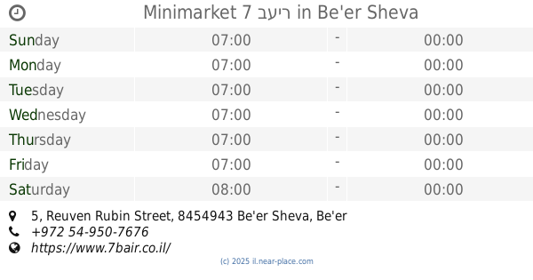
Minimarket 7 בעיר
Reuven Rubin Street 5, Be'er Sheva
Supermarket
Convenience store
Grocery or supermarket
Food
Point of interest
Store
Establishment
read more
45.467 km
עליזה
Be'er Sheva
Convenience store
read more
46.327 km
מינימרקט הבנים
גוש עציון 46, באר שבע
Convenience store
read more
46.509 km
ג'י פוינט
מרכז פלאזה, יצחק נפחא 25, באר שבע
Convenience store
read more
49.325 km
Grocery Store
משאבי שדה
Convenience store
read more
49.325 km
Grocery Store
Mashabei Sadeh
Convenience store
read more
60.155 km
מכולת בן אלי
Exodus Street 13, Kiryat Gat
Convenience store
read more
61.585 km
המכולת של מזל
הצבעוני 74, קרית גת
Convenience store
read more
61.585 km
Lucky's grocery store
HaYasmin Street 74, Kiryat Gat
Convenience store
read more
61.832 km
מכולת כהן דוד
עתניאל בן קנז 6, קרית גת
Convenience store
read more
📑
all categories
Accounting
Administrative area level 1
Administrative area level 2
Airport
Amusement park
Aquarium
Art gallery
Atm
Bakery
Bank
Bar
Beauty salon
Bicycle store
Book store
Bowling alley
Bus station
Cafe
Campground
Car dealer
Car rental
Car repair
Car wash
Casino
Cemetery
Church
City hall
Clothing store
Colloquial area
Convenience store
Country
Courthouse
Dentist
Department store
Doctor
Electrician
Electronics store
Embassy
Establishment
Finance
Fire station
Florist
Food
Funeral home
Furniture store
Gas station
General contractor
Grocery or supermarket
Gym
Hair care
Hardware store
Health
Hindu Temple
Home goods store
Hospital
Insurance agency
Intersection
Jewelry store
Laundry
Lawyer
Library
Light rail station
Liquor store
Local government office
Locality
Locksmith
Lodging
Meal delivery
Meal takeaway
Mosque
Movie rental
Movie theater
Moving company
Museum
Natural feature
Neighborhood
Night club
Painter
Park
Parking
Pet store
Pharmacy
Physiotherapist
Place of worship
Plumber
Point of interest
Police
Political
Post office
Premise
Real estate agency
Restaurant
Roofing contractor
Route
Rv park, camping
School
Shoe store
Shopping mall
Spa
Stadium
Storage
Store
Subpremise
Subway station
Supermarket
Synagogue
Taxi stand
Train station
Transit station
Travel agency
University
Veterinary care
Zoo
administrative area level 3
administrative area level 4
sublocality level 1
↑