Clothing store nearby ملبوسات الامان
Israel
Clothing store nearby ملبوسات الامان
ملبوسات الامان
כפר מנדא, ישראל
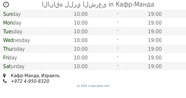
contacts phone
:
+972
Latitude:
32.8076413
, Longitude:
35.2590899
larger map & directions
read more
nearest Clothing store
ملبوسات الامان
Kafr Manda
Clothing store
read more
119 m
معرض العروس
ראמז בושנאק, כפר מנדא
Clothing store
read more
119 m
معرض العروس
Ramaz Bushnak Street, Kafr Manda
Clothing store
read more
168 m
Elvana Style
כפר מנדא
Clothing store
read more
183 m
Butterfly Fashion
Kafr Manda
Clothing store
read more
227 m
ملبوسات بيسان Voltaj
Kafr Manda
Clothing store
read more
246 m
ملبوسات بيسان
Kafr Manda
Clothing store
read more
272 m
מוצרי תינוקות m&g kids
כפר מנדא
Clothing store
read more
272 m
מוצרי תינוקות m&g kids
Kafr Manda
Clothing store
read more
411 m
Kiwi Kids
Kafr Manda
Clothing store
read more
411 m
קיווי קידס
Kafr Manda
Clothing store
read more
431 m
الاناقة للزي الشرعي
כפר מנדא
Clothing store
read more
431 m
الاناقة للزي الشرعي
Kafr Manda
Clothing store
read more
527 m
Nirvana Style
כפר מנדא
Clothing store
read more
3.86 km
אחו - הבגדים עם הכבשה
המעגל, Yodfat
Clothing store
read more
4.83 km
חנות גדיר שריף לביגוד
Unnamed Road, Bir al-Maksur
Clothing store
read more
4.83 km
أزياء شريف غدير
Unnamed Road, Bir al-Maksur
Clothing store
read more
5.321 km
Free Be
HaTe'ena Street 76, Manof
Clothing store
read more
5.321 km
Free Be
התאנה 76, מנוף
Clothing store
read more
13.035 km
נאוטיקה
תופיק זיאד 53, נצרת
Clothing store
read more
13.397 km
Afrodita
דרך העמק 41, נצרת עילית
Clothing store
read more
13.697 km
Carhartt Ramat Yishai
Ramat Yishai
Clothing store
read more
14.548 km
Yoop
Ma'ale Kamon Street 2, Karmiel
Clothing store
read more
14.64 km
תמנון
Ma'ale Kamon Street 2, Karmiel
Clothing store
read more
14.764 km
קיווי קידס
מעלה כמון 5, קניון חוצות כרמיאל, Karmiel
Clothing store
read more
📑
all categories
Accounting
Administrative area level 1
Administrative area level 2
Airport
Amusement park
Aquarium
Art gallery
Atm
Bakery
Bank
Bar
Beauty salon
Bicycle store
Book store
Bowling alley
Bus station
Cafe
Campground
Car dealer
Car rental
Car repair
Car wash
Casino
Cemetery
Church
City hall
Clothing store
Colloquial area
Convenience store
Country
Courthouse
Dentist
Department store
Doctor
Electrician
Electronics store
Embassy
Establishment
Finance
Fire station
Florist
Food
Funeral home
Furniture store
Gas station
General contractor
Grocery or supermarket
Gym
Hair care
Hardware store
Health
Hindu Temple
Home goods store
Hospital
Insurance agency
Intersection
Jewelry store
Laundry
Lawyer
Library
Light rail station
Liquor store
Local government office
Locality
Locksmith
Lodging
Meal delivery
Meal takeaway
Mosque
Movie rental
Movie theater
Moving company
Museum
Natural feature
Neighborhood
Night club
Painter
Park
Parking
Pet store
Pharmacy
Physiotherapist
Place of worship
Plumber
Point of interest
Police
Political
Post office
Premise
Real estate agency
Restaurant
Roofing contractor
Route
Rv park, camping
School
Shoe store
Shopping mall
Spa
Stadium
Storage
Store
Subpremise
Subway station
Supermarket
Synagogue
Taxi stand
Train station
Transit station
Travel agency
University
Veterinary care
Zoo
administrative area level 3
administrative area level 4
sublocality level 1
↑