City hall nearby בני יהודה
Israel
City hall nearby בני יהודה
בני יהודה
צפת
contacts phone
:
+972
Latitude:
32.9933473
, Longitude:
35.6813582
larger map & directions
read more
nearest City hall
14.95 km
Gonen Administration Office
105, Gonen
City hall
read more
14.95 km
Gonen Administration Office
105, גונן
City hall
read more
17.779 km
Safed Municipality
Jerusalem Street 50, Safed
City hall
read more
17.779 km
עיריית צפת
ירושלים 50, צפת
City hall
read more
17.779 km
Safed City Hall
Jerusalem Street 50, Safed
City hall
read more
24.721 km
הוועדה המקומית גליל עליון
תל חי, קרית שמונה
City hall
read more
25.816 km
המועצה האזורית גליל עליון
הגושרים
City hall
read more
25.991 km
Kiryat Shmona municipality
Herzl Street 37, Qiryat Shemona
City hall
read more
25.991 km
עיריית קרית שמונה
הרצל 37, קרית שמונה
City hall
read more
25.991 km
Kiryat Shmona City Hall
Herzl Street 37, Qiryat Shemona
City hall
read more
31.867 km
Regional Council of Majdal Shams
Majdal Shams
City hall
read more
37.364 km
Karmiel City Hall
שד' קק"ל 100, כרמיאל
City hall
read more
37.375 km
قاعة ابو توفيق
Sakhnin
City hall
read more
47.321 km
עיריית נצרת עילית
גלבוע 16, נצרת עילית
City hall
read more
47.339 km
Tamra Municipality
Tamra
City hall
read more
47.339 km
עיריית טמרה
טמרה
City hall
read more
54.333 km
Migdal Haemek City Hall
Derech HaEmek 14, Migdal HaEmek
City hall
read more
54.967 km
מזכירות עין חרוד איחוד
עין חרוד איחוד
City hall
read more
55.499 km
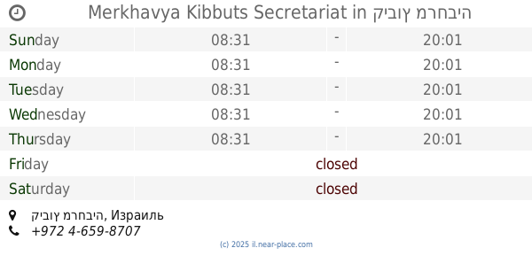
Merkhavya Kibbuts Secretariat
קיבוץ מרחביה
City hall
read more
55.499 km
מזכירות מרחביה קיבוץ
קיבוץ מרחביה
City hall
read more
56.605 km
עיריית עפולה
יהושע חנקין 47, עפולה
City hall
read more
56.605 km
עיריית עפולה
Joshua Hankin Street 47, Afula
City hall
read more
56.827 km
מקווה גברים
Ya'akov Kinamon Street 21, Afula
City hall
read more
56.827 km
מקווה גברים
יעקב קינמון 21, עפולה
City hall
read more
61.461 km
Secretariat Hayogv
HaYogev
City hall
read more
📑
all categories
Accounting
Administrative area level 1
Administrative area level 2
Airport
Amusement park
Aquarium
Art gallery
Atm
Bakery
Bank
Bar
Beauty salon
Bicycle store
Book store
Bowling alley
Bus station
Cafe
Campground
Car dealer
Car rental
Car repair
Car wash
Casino
Cemetery
Church
City hall
Clothing store
Colloquial area
Convenience store
Country
Courthouse
Dentist
Department store
Doctor
Electrician
Electronics store
Embassy
Establishment
Finance
Fire station
Florist
Food
Funeral home
Furniture store
Gas station
General contractor
Grocery or supermarket
Gym
Hair care
Hardware store
Health
Hindu Temple
Home goods store
Hospital
Insurance agency
Intersection
Jewelry store
Laundry
Lawyer
Library
Light rail station
Liquor store
Local government office
Locality
Locksmith
Lodging
Meal delivery
Meal takeaway
Mosque
Movie rental
Movie theater
Moving company
Museum
Natural feature
Neighborhood
Night club
Painter
Park
Parking
Pet store
Pharmacy
Physiotherapist
Place of worship
Plumber
Point of interest
Police
Political
Post office
Premise
Real estate agency
Restaurant
Roofing contractor
Route
Rv park, camping
School
Shoe store
Shopping mall
Spa
Stadium
Storage
Store
Subpremise
Subway station
Supermarket
Synagogue
Taxi stand
Train station
Transit station
Travel agency
University
Veterinary care
Zoo
administrative area level 3
administrative area level 4
sublocality level 1
↑