Church nearby Franciscan monastery
Israel
Church nearby Franciscan monastery
Franciscan monastery
Israel
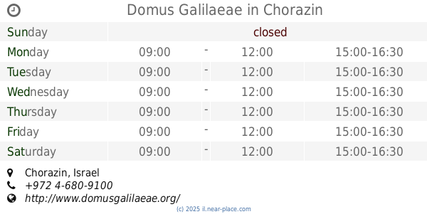
contacts phone
:
+972
Latitude:
32.8804308
, Longitude:
35.5744549
larger map & directions
read more
nearest Church
86 m
Capharnaum The Town Of Jesus
Israel
Church
read more
295 m
כנסיית 12 השליחים
Israel
Church
read more
1.666 km
Berg der Seligpreisungen
Israel
Church
read more
1.677 km
Monte Delle Beatitudini
8177
Church
read more
1.685 km
מנזר הביאטיטודים
Israel
Church
read more
1.685 km
Церковь Блаженств
Israel
Church
read more
1.685 km
Góra Błogosławieństw
Israel
Church
read more
1.685 km
The Beatitude Monastery
Israel
Church
read more
2.436 km
Mensa Domini Church
Tabgha
Church
read more
2.436 km
כנסיית מנזה דומיני
עין שבע
Church
read more
2.436 km
Church of the Primacy of Saint Peter
Tabgha
Church
read more
2.436 km
Mensa Domini Church
Israel
Church
read more
2.487 km
טבחה
Israel
Church
read more
2.487 km
Tabgha
Israel
Church
read more
3.215 km
Domus Galilaeae
Chorazin
Church
read more
10.243 km
הכנסייה הסקוטית
Tiberias
Church
read more
10.626 km
St Andrew's Church
Gdud Barak Street 1, Tiberias
Church
read more
10.684 km
כנסיית סנט פיטר
טבריה
Church
read more
10.684 km
St. Peter's Church
Tiberias
Church
read more
10.694 km
קהילה משיחית כוכב השחר
4, HaAtsmaut Street, Tiberias
Church
read more
11.022 km
Monastery of 12 Apostles
טבריה
Church
read more
11.022 km
Monastery of 12 Apostles
Tiberias
Church
read more
11.071 km
Greek Church & Monastery
Tiberias
Church
read more
13.012 km
Messianic Congregation
המשור, טבריה
Church
read more
13.012 km
Messianic Congregation
Ha-Masor Street, Tiberias
Church
read more
📑
all categories
Accounting
Administrative area level 1
Administrative area level 2
Airport
Amusement park
Aquarium
Art gallery
Atm
Bakery
Bank
Bar
Beauty salon
Bicycle store
Book store
Bowling alley
Bus station
Cafe
Campground
Car dealer
Car rental
Car repair
Car wash
Casino
Cemetery
Church
City hall
Clothing store
Colloquial area
Convenience store
Country
Courthouse
Dentist
Department store
Doctor
Electrician
Electronics store
Embassy
Establishment
Finance
Fire station
Florist
Food
Funeral home
Furniture store
Gas station
General contractor
Grocery or supermarket
Gym
Hair care
Hardware store
Health
Hindu Temple
Home goods store
Hospital
Insurance agency
Intersection
Jewelry store
Laundry
Lawyer
Library
Light rail station
Liquor store
Local government office
Locality
Locksmith
Lodging
Meal delivery
Meal takeaway
Mosque
Movie rental
Movie theater
Moving company
Museum
Natural feature
Neighborhood
Night club
Painter
Park
Parking
Pet store
Pharmacy
Physiotherapist
Place of worship
Plumber
Point of interest
Police
Political
Post office
Premise
Real estate agency
Restaurant
Roofing contractor
Route
Rv park, camping
School
Shoe store
Shopping mall
Spa
Stadium
Storage
Store
Subpremise
Subway station
Supermarket
Synagogue
Taxi stand
Train station
Transit station
Travel agency
University
Veterinary care
Zoo
administrative area level 3
administrative area level 4
sublocality level 1
↑