Church nearby Ethiopian Patriarchate
Israel
Church nearby Ethiopian Patriarchate
Ethiopian Patriarchate
Jerusalén
contacts phone
:
+972
Latitude:
31.779493
, Longitude:
35.230264
larger map & directions
read more
nearest Church
125 m
Santa Veronica
Jerusalem
Church
read more
137 m
Via Dolorosa
ירושלים
Church
read more
159 m
מנזר סנט אברהם
ירושלים
Church
read more
198 m
Serbian monastry St.Archangels
סנט פרנציס, ירושלים
Church
read more
199 m
The Danish Church in Jerusalem
מוריסטאן 15, ירושלים
Church
read more
206 m
כנסיית מריה של הייסורים
ירושלים
Church
read more
275 m
סנט סלוואדור
ירושלים
Church
read more
280 m
כנסיית יוחנן המטביל
ירושלים
Church
read more
280 m
Iglesia de San Juan el Bautista
Jerusalem
Church
read more
280 m
Johanneskirche
Jerusalem
Church
read more
284 m
מנזר קאזה נובה
n1, Saint Francis Street, Jerusalem
Church
read more
395 m
Церковь Христа
The Armenian Patriarchate Street 55, Jerusalem
Church
read more
395 m
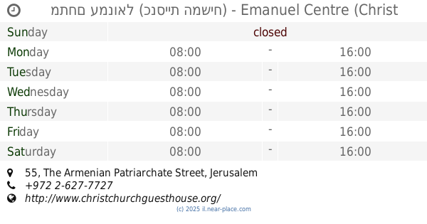
מתחם עמנואל (כנסיית המשיח) - Emanuel Centre (Christ Church)
The Armenian Patriarchate Street 55, Jerusalem
Cafe
Museum
Lodging
Church
Place of worship
Food
Point of interest
Establishment
read more
395 m
כנסית המשיח
הפטריארכיה הארמנית 55, ירושלים
Church
read more
451 m
Deir Salzayani
Jerusalem
Church
read more
556 m
Saint Vincent de Paul Monastery
Jerusalem
Church
read more
573 m
Iglesia de Santa Ana
Jerusalem
Church
read more
573 m
St. Anne's Church
ירושלים
Church
read more
573 m
Базилика Святой Анны
Jerusalem
Church
read more
625 m
סנט אטיין
Nablus Road 83, ירושלים
Church
read more
733 m
Dreifaltigkeitskathedrale
Jerusalem
Church
read more
733 m
קתדרלת השילוש הקדוש
ירושלים
Church
read more
947 m
כנסיית סנט ג'ורג'
ירושלים
Church
read more
978 m
מנזר הלזריסטים
ירושלים
Church
read more
1.052 km
כנסיית החבשים
ירושלים
Church
read more
📑
all categories
Accounting
Administrative area level 1
Administrative area level 2
Airport
Amusement park
Aquarium
Art gallery
Atm
Bakery
Bank
Bar
Beauty salon
Bicycle store
Book store
Bowling alley
Bus station
Cafe
Campground
Car dealer
Car rental
Car repair
Car wash
Casino
Cemetery
Church
City hall
Clothing store
Colloquial area
Convenience store
Country
Courthouse
Dentist
Department store
Doctor
Electrician
Electronics store
Embassy
Establishment
Finance
Fire station
Florist
Food
Funeral home
Furniture store
Gas station
General contractor
Grocery or supermarket
Gym
Hair care
Hardware store
Health
Hindu Temple
Home goods store
Hospital
Insurance agency
Intersection
Jewelry store
Laundry
Lawyer
Library
Light rail station
Liquor store
Local government office
Locality
Locksmith
Lodging
Meal delivery
Meal takeaway
Mosque
Movie rental
Movie theater
Moving company
Museum
Natural feature
Neighborhood
Night club
Painter
Park
Parking
Pet store
Pharmacy
Physiotherapist
Place of worship
Plumber
Point of interest
Police
Political
Post office
Premise
Real estate agency
Restaurant
Roofing contractor
Route
Rv park, camping
School
Shoe store
Shopping mall
Spa
Stadium
Storage
Store
Subpremise
Subway station
Supermarket
Synagogue
Taxi stand
Train station
Transit station
Travel agency
University
Veterinary care
Zoo
administrative area level 3
administrative area level 4
sublocality level 1
↑