Church nearby Church of the Holy Heart
Coronavirus disease (COVID-19) Situation
confirmed cases
4841772
deaths
12707
Israel
Church nearby Church of the Holy Heart
Church of the Holy Heart
Haifa, Israel
contacts phone
:
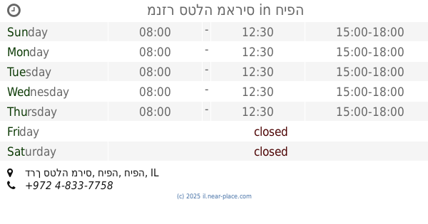
+972 4-833-7758
Latitude:
32.828668
, Longitude:
34.966301
larger map & directions
read more
nearest Church
309 m
השביל לקפלת המשפחה הקדושה
דרך סטלה מריס, חיפה
Church
read more
319 m
Teresa's Church of the Holy
Haifa
Church
read more
319 m
כנסיית תרזה הקדושה
חיפה
Church
read more
348 m
St. Gregory Church
Haifa
Church
read more
392 m
Монастырь Стелла Марис
Stella Maris Road, Haifa
Church
read more
392 m
Monasterio de Stella Maris
Stella Maris Road, Haifa
Church
read more
392 m
Stella Maris Monastery
Stella Maris Road, Haifa
Church
read more
392 m
מנזר סטלה מאריס
דרך סטלה מריס, חיפה
Church
read more
1.644 km
The Carmelite Monastery
Haifa
Church
read more
1.644 km
מנזר הכרמליטיות
חיפה
Church
read more
1.926 km
St. Gabriel Church
Haifa
Church
read more
2.168 km
Russian Orthodox Haifa Church
Ha-Tishbi Street 51-55, Haifa
Church
read more
2.19 km
Russian Church
Haifa
Church
read more
2.19 km
כנסייה רוסית
חיפה
Church
read more
2.29 km
Greek Catholic Archbishopric Of Akka,haifa,Nazareth & Gallilee
HaGefen Street 35, Haifa
Church
read more
2.498 km
Baptist Church
Haifa
Church
read more
2.498 km
כנסייה בפטיסטית
חיפה
Church
read more
2.696 km
St.joseph Church
80,, Sderot HaMeginim 76, Haifa
Church
read more
2.847 km
כנסיית אליאס
עין דור 19, חיפה
Church
read more
2.884 km
Церковь Святого Иоанна
ח'ורי 32, חיפה
Church
read more
2.92 km
כנסיית יוחנן הקדוש חיפה
ח'ורי 24-30, חיפה
Church
read more
3.002 km
Saint Elijah Armenian Church
Haifa
Church
read more
3.534 km
IURD Haifa
בלפור 1, חיפה
Church
read more
3.534 km
IURD Haifa
Balfour Street 1, Haifa
Church
read more
3.556 km
Universal Church of Kingdom of God
בלפור 3, חיפה
Church
read more
📑
all categories
Accounting
Administrative area level 1
Administrative area level 2
Airport
Amusement park
Aquarium
Art gallery
Atm
Bakery
Bank
Bar
Beauty salon
Bicycle store
Book store
Bowling alley
Bus station
Cafe
Campground
Car dealer
Car rental
Car repair
Car wash
Casino
Cemetery
Church
City hall
Clothing store
Colloquial area
Convenience store
Country
Courthouse
Dentist
Department store
Doctor
Electrician
Electronics store
Embassy
Establishment
Finance
Fire station
Florist
Food
Funeral home
Furniture store
Gas station
General contractor
Grocery or supermarket
Gym
Hair care
Hardware store
Health
Hindu Temple
Home goods store
Hospital
Insurance agency
Intersection
Jewelry store
Laundry
Lawyer
Library
Light rail station
Liquor store
Local government office
Locality
Locksmith
Lodging
Meal delivery
Meal takeaway
Mosque
Movie rental
Movie theater
Moving company
Museum
Natural feature
Neighborhood
Night club
Painter
Park
Parking
Pet store
Pharmacy
Physiotherapist
Place of worship
Plumber
Point of interest
Police
Political
Post office
Premise
Real estate agency
Restaurant
Roofing contractor
Route
Rv park, camping
School
Shoe store
Shopping mall
Spa
Stadium
Storage
Store
Subpremise
Subway station
Supermarket
Synagogue
Taxi stand
Train station
Transit station
Travel agency
University
Veterinary care
Zoo
administrative area level 3
administrative area level 4
sublocality level 1
↑