Church nearby Baptist Church
Israel
Church nearby Baptist Church
Baptist Church
Tur'an, Израиль
contacts phone
:
+972
Latitude:
32.775572
, Longitude:
35.372426
larger map & directions
read more
nearest Church
כנסייה בפטיסטית
טורעאן
Church
read more
100 m
כנסייה יוונית אורתודוקסית
טורעאן
Church
read more
100 m
Greek Orthodox Church
Tur'an
Church
read more
4.438 km
Nathaniel Bartholomew Church
Kafr Kanna
Church
read more
4.462 km
Saint Simon The Cananite Chapel
Kafr Kanna
Church
read more
4.49 km
Cana Catholic Wedding Church
Kafr Kanna
Church
read more
4.49 km
כנסיית החתונה הקתולית
כפר כנא
Church
read more
4.49 km
The Wedding Church
Kafr Kanna
Church
read more
4.517 km
Biserica Grec. Ortodoxa
כפר כנא
Church
read more
4.517 km
Греческая Церковь
Kafr Kanna
Church
read more
4.533 km
כנסייה יוונית קתולית
כפר כנא
Church
read more
4.533 km
Greek Catholic Church
Kafr Kanna
Church
read more
4.585 km
Cana Baptist Church
Kafr Kanna
Church
read more
4.585 km
Cana Baptist Church
כפר כנא
Church
read more
9.183 km
Upper Nazareth Baptist Church
המוכתר מוהנה 25, נצרת עילית
Church
read more
10.127 km
Гора фавор
Nazareth
Church
read more
10.144 km
Baptist Church
Nazareth
Church
read more
10.252 km
كنيسة البشارة القبطية
Nazareth
Church
read more
10.765 km
Bazylika Zwiastowania Pańskiego w Nazarecie
Nazareth
Church
read more
10.778 km
Sisters of Nazareth Convent
Nazareth
Church
read more
10.897 km
Basilique Cathodique de l'Annonciation
Paulus ha-Shishi Street 6172, Nazareth
Church
read more
12.331 km
קתדרלה קתולית
סח'נין
Church
read more
13.12 km
Latin Patriarchate Church
Yafa an-Naseriyye
Church
read more
13.256 km
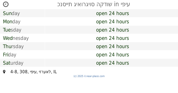
כנסיית גיאורגיוס הקדוש
308 4-8, יפיע
Church
read more
14.99 km
הכנסייה הסקוטית
Tiberias
Church
read more
📑
all categories
Accounting
Administrative area level 1
Administrative area level 2
Airport
Amusement park
Aquarium
Art gallery
Atm
Bakery
Bank
Bar
Beauty salon
Bicycle store
Book store
Bowling alley
Bus station
Cafe
Campground
Car dealer
Car rental
Car repair
Car wash
Casino
Cemetery
Church
City hall
Clothing store
Colloquial area
Convenience store
Country
Courthouse
Dentist
Department store
Doctor
Electrician
Electronics store
Embassy
Establishment
Finance
Fire station
Florist
Food
Funeral home
Furniture store
Gas station
General contractor
Grocery or supermarket
Gym
Hair care
Hardware store
Health
Hindu Temple
Home goods store
Hospital
Insurance agency
Intersection
Jewelry store
Laundry
Lawyer
Library
Light rail station
Liquor store
Local government office
Locality
Locksmith
Lodging
Meal delivery
Meal takeaway
Mosque
Movie rental
Movie theater
Moving company
Museum
Natural feature
Neighborhood
Night club
Painter
Park
Parking
Pet store
Pharmacy
Physiotherapist
Place of worship
Plumber
Point of interest
Police
Political
Post office
Premise
Real estate agency
Restaurant
Roofing contractor
Route
Rv park, camping
School
Shoe store
Shopping mall
Spa
Stadium
Storage
Store
Subpremise
Subway station
Supermarket
Synagogue
Taxi stand
Train station
Transit station
Travel agency
University
Veterinary care
Zoo
administrative area level 3
administrative area level 4
sublocality level 1
↑