Cemetery nearby בית העלמין הקוממיות כניסת רכבים
Israel
Cemetery nearby בית העלמין הקוממיות כניסת רכבים
בית העלמין הקוממיות כניסת רכבים
Бат-Ям, Израиль
contacts phone
:
+972
Latitude:
31.9981011
, Longitude:
34.7582896
larger map & directions
read more
nearest Cemetery
21 m
Military cemetery
Ha-Komemiyut St, בת ים
Cemetery
read more
21 m
בית קברות צבאי
Ha-Komemiyut St, בת ים
Cemetery
read more
21 m
Военное кладбище
Ha-Komemiyut St, בת ים
Cemetery
read more
4.182 km
בחובו
ראשון לציון
Cemetery
read more
4.182 km
בחובו
Rishon LeTsiyon
Cemetery
read more
4.259 km
בית קברות יווני קתולי
תל אביב יפו
Cemetery
read more
4.259 km
Greek Catholic Cemetery
Тель-Авив
Cemetery
read more
4.259 km
Greek Catholic Cemetery
Tel Awiw
Cemetery
read more
4.259 km
Greek Catholic Cemetery
Tel Aviv-Yafo
Cemetery
read more
4.308 km
Latin Cemetery
Тель-Авив
Cemetery
read more
4.308 km
בית קברות לטיני
תל אביב יפו
Cemetery
read more
4.308 km
Latin Cemetery
Tel Aviv-Yafo
Cemetery
read more
4.435 km
Tel Aviv Muslim Cemetery
Tel Aviv-Yafo
Cemetery
read more
4.435 km
Tel Aviv Muslim Cemetery
Tel Awiw
Cemetery
read more
4.435 km
בית קברות תל אביב מוסלמי
תל אביב יפו
Cemetery
read more
5.171 km
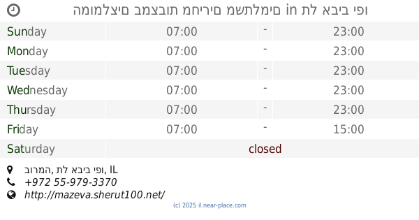
המומלצים במצבות מחירים משתלמים
בורמה, תל אביב יפו
Cemetery
read more
5.171 km
Recommended tombstones great value
Burma Street, Tel Aviv-Yafo
Cemetery
read more
7.898 km
minerala
אלנבי 63, תל אביב יפו
Cemetery
read more
9.23 km
Be'er Ya'akov Cemetery
Be'er Ya'akov
Cemetery
read more
9.23 km
Be'er Ya'akov Cemetery
Беэр-Яаков
Cemetery
read more
10.439 km
Emek Lod Ahi'ezer Regional Cemetery
Ahi'ezer
Cemetery
read more
10.93 km
בית קברות בני ברק
בני ברק
Cemetery
read more
12.838 km
المقبرة العسكرية رحوفوت
רחובות
Cemetery
read more
13.078 km
בית עלמין רמלה
רמלה
Cemetery
read more
15.819 km
Matsli'akh Cemetery
Израиль
Cemetery
read more
📑
all categories
Accounting
Administrative area level 1
Administrative area level 2
Airport
Amusement park
Aquarium
Art gallery
Atm
Bakery
Bank
Bar
Beauty salon
Bicycle store
Book store
Bowling alley
Bus station
Cafe
Campground
Car dealer
Car rental
Car repair
Car wash
Casino
Cemetery
Church
City hall
Clothing store
Colloquial area
Convenience store
Country
Courthouse
Dentist
Department store
Doctor
Electrician
Electronics store
Embassy
Establishment
Finance
Fire station
Florist
Food
Funeral home
Furniture store
Gas station
General contractor
Grocery or supermarket
Gym
Hair care
Hardware store
Health
Hindu Temple
Home goods store
Hospital
Insurance agency
Intersection
Jewelry store
Laundry
Lawyer
Library
Light rail station
Liquor store
Local government office
Locality
Locksmith
Lodging
Meal delivery
Meal takeaway
Mosque
Movie rental
Movie theater
Moving company
Museum
Natural feature
Neighborhood
Night club
Painter
Park
Parking
Pet store
Pharmacy
Physiotherapist
Place of worship
Plumber
Point of interest
Police
Political
Post office
Premise
Real estate agency
Restaurant
Roofing contractor
Route
Rv park, camping
School
Shoe store
Shopping mall
Spa
Stadium
Storage
Store
Subpremise
Subway station
Supermarket
Synagogue
Taxi stand
Train station
Transit station
Travel agency
University
Veterinary care
Zoo
administrative area level 3
administrative area level 4
sublocality level 1
↑