Cafe nearby טיפת מזל
Israel
Cafe nearby טיפת מזל
טיפת מזל
1, יגאל אלון, תל אביב יפו, IL ישראל
contacts phone
:
+972
Latitude:
32.0540747
, Longitude:
34.7915735
larger map & directions
read more
nearest Cafe
179 m
cofix
Etsel Street 25, Tel Aviv-Yafo
Cafe
read more
179 m
קופיקס
אצ"ל 25, תל אביב יפו
Cafe
read more
179 m
Кофикс
Etsel Street 25, Tel Aviv-Yafo
Cafe
read more
579 m
פינת התרנגול
אצ״ל 64, תל אביב יפו
Cafe
read more
638 m
קפה גורו
Pe Dalet Street 2, Tel Aviv-Yafo
Cafe
read more
737 m
ממתקי מוטראן
Etsel Street 78, Tel Aviv-Yafo
Cafe
read more
737 m
ממתקי מוטראן
אצ"ל 78, תל אביב יפו
Cafe
read more
745 m
קפה ברנרד
אריאל, תל אביב יפו
Cafe
read more
856 m
אילנ'ס קפה
היכל מנורה מבטחים, השלושה 1, תל אביב יפו
Cafe
read more
942 m
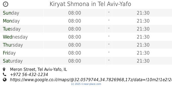
Kiryat Shmona
Meron Street, Tel Aviv-Yafo
Cafe
read more
963 m
WAYCUP coffee & food
Yigal Alon Street 55, Tel Aviv-Yafo
Cafe
read more
983 m
קפה ועוד
נירים 3, תל אביב יפו
Cafe
read more
983 m
Caffee Veod . . .
Nirim Street 3, Tel Aviv-Yafo
Cafe
read more
1.11 km
Aroma
HaMasger Street 9, Tel Aviv-Yafo
Cafe
read more
1.216 km
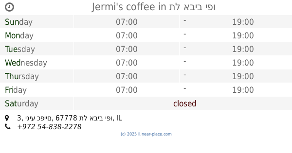
Jermi's coffee
יגיע כפיים 3, תל אביב יפו
Cafe
read more
1.216 km
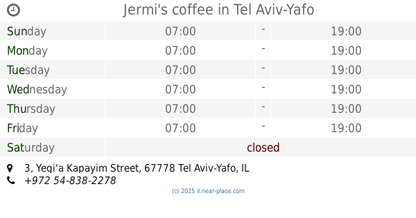
Jermi's coffee
Yegi'a Kapayim Street 3, Tel Aviv-Yafo
Cafe
read more
1.235 km
סמארט אספרסו
Rival Street 18, Tel Aviv-Yafo
Cafe
read more
1.238 km
Kafe "Pavion"
יגיע כפיים 18, תל אביב יפו
Cafe
read more
1.238 km
Kafe "Pavion"
Yegi'a Kapayim Street 18, Tel Aviv-Yafo
Cafe
read more
1.248 km
Mister Juוse
ריב"ל 15, תל אביב יפו
Cafe
read more
1.248 km
Mister Juוse
Rival Street 15, Tel Aviv-Yafo
Cafe
read more
1.316 km
Cofix
ריב"ל 7, תל אביב יפו
Cafe
read more
1.316 km
Кофикс
Rival Street 7, Tel Aviv-Yafo
Cafe
read more
1.374 km
Tuchka Bakery
Rival Street 5, Tel Aviv-Yafo
Cafe
read more
1.374 km
Tuchka Bakery
ריב"ל 5, תל אביב יפו
Cafe
read more
📑
all categories
Accounting
Administrative area level 1
Administrative area level 2
Airport
Amusement park
Aquarium
Art gallery
Atm
Bakery
Bank
Bar
Beauty salon
Bicycle store
Book store
Bowling alley
Bus station
Cafe
Campground
Car dealer
Car rental
Car repair
Car wash
Casino
Cemetery
Church
City hall
Clothing store
Colloquial area
Convenience store
Country
Courthouse
Dentist
Department store
Doctor
Electrician
Electronics store
Embassy
Establishment
Finance
Fire station
Florist
Food
Funeral home
Furniture store
Gas station
General contractor
Grocery or supermarket
Gym
Hair care
Hardware store
Health
Hindu Temple
Home goods store
Hospital
Insurance agency
Intersection
Jewelry store
Laundry
Lawyer
Library
Light rail station
Liquor store
Local government office
Locality
Locksmith
Lodging
Meal delivery
Meal takeaway
Mosque
Movie rental
Movie theater
Moving company
Museum
Natural feature
Neighborhood
Night club
Painter
Park
Parking
Pet store
Pharmacy
Physiotherapist
Place of worship
Plumber
Point of interest
Police
Political
Post office
Premise
Real estate agency
Restaurant
Roofing contractor
Route
Rv park, camping
School
Shoe store
Shopping mall
Spa
Stadium
Storage
Store
Subpremise
Subway station
Supermarket
Synagogue
Taxi stand
Train station
Transit station
Travel agency
University
Veterinary care
Zoo
administrative area level 3
administrative area level 4
sublocality level 1
↑