Cafe nearby Rimon Cafe
Israel
Cafe nearby Rimon Cafe
Rimon Cafe
4, Ben Yehuda Street, 9462604, Jerusalem, IL Israel
contacts phone
:
+972 2-624-3712
website:
www.caferimon.co.il
Latitude:
31.7817373
, Longitude:
35.2185848
larger map & directions
read more
nearest Cafe
38 m
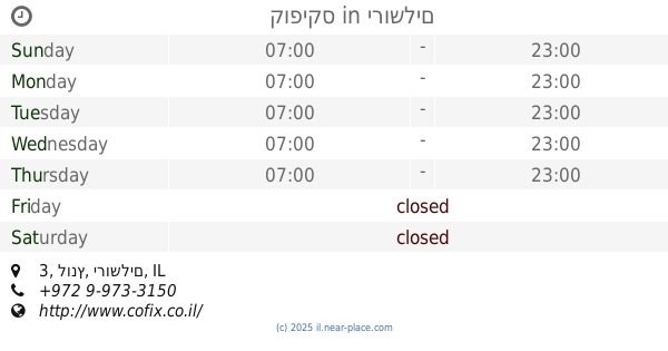
cofix
Lunz Street 3, Jerusalem
Cafe
read more
38 m
קופיקס
לונץ 3, ירושלים
Cafe
read more
64 m
Sam's Bagels
Ben Yehuda 11, Jerusalem
Cafe
read more
130 m
המאפין בוטיק
בן יהודה 16, ירושלים
Cafe
read more
148 m
Aroma
Jaffa Street 40, Jerusalem
Cafe
read more
148 m
Aroma
יפו 40, ירושלים
Cafe
read more
169 m
פרי שייק בר
Darom Street, Jerusalem
Cafe
read more
180 m
Coffizz
Jaffa Street 31, Jerusalem
Cafe
read more
303 m
five coffee
יפו 34, ירושלים
Cafe
read more
320 m
Norbert
Be'eri Street 3, Jerusalem
Cafe
read more
327 m
עוגת חן
יפו 30, ירושלים
Cafe
read more
345 m
Coffee Nadi
מעונות הסטודנטים, הלל 39, ירושלים
Cafe
Food
Point of interest
Store
Establishment
read more
358 m
You Need Coffee
Jaffa Street 30, Jerusalem
Cafe
read more
394 m
Coffee Nadi
שמואל הנגיד פינת פינת ש"ץ 5, Jerusalem
Cafe
read more
412 m
קפה סירה
בן סירא 1, ירושלים
Cafe
read more
445 m
קפה פורטה
יפו 97, ירושלים
Cafe
read more
470 m
מודוס קפה בר
המלך ג'ורג' 31, ירושלים
Cafe
read more
550 m
אגרונסקי
גרשון אגרון 24, ירושלים
Cafe
read more
562 m
פינוקית
מרדכי נרקיס 8, ירושלים
Cafe
read more
562 m
פינוקית
מרדכי נרקיס 6, ירושלים
Cafe
read more
625 m
Baklava Machnayehuda
עץ חיים 2, ירושלים
Cafe
read more
643 m
עיר דוד
Etz Hayyim Street, Jerusalem
Cafe
read more
806 m
בוטיק נספרסו ממילא
Yitshak Kariv Street 4, Jerusalem
Cafe
read more
949 m
SOS Cafe
ירושלים
Cafe
read more
983 m
Jerusalem Hotel
Antara Ben Shadad Street 15, Jerusalem
Cafe
read more
📑
all categories
Accounting
Administrative area level 1
Administrative area level 2
Airport
Amusement park
Aquarium
Art gallery
Atm
Bakery
Bank
Bar
Beauty salon
Bicycle store
Book store
Bowling alley
Bus station
Cafe
Campground
Car dealer
Car rental
Car repair
Car wash
Casino
Cemetery
Church
City hall
Clothing store
Colloquial area
Convenience store
Country
Courthouse
Dentist
Department store
Doctor
Electrician
Electronics store
Embassy
Establishment
Finance
Fire station
Florist
Food
Funeral home
Furniture store
Gas station
General contractor
Grocery or supermarket
Gym
Hair care
Hardware store
Health
Hindu Temple
Home goods store
Hospital
Insurance agency
Intersection
Jewelry store
Laundry
Lawyer
Library
Light rail station
Liquor store
Local government office
Locality
Locksmith
Lodging
Meal delivery
Meal takeaway
Mosque
Movie rental
Movie theater
Moving company
Museum
Natural feature
Neighborhood
Night club
Painter
Park
Parking
Pet store
Pharmacy
Physiotherapist
Place of worship
Plumber
Point of interest
Police
Political
Post office
Premise
Real estate agency
Restaurant
Roofing contractor
Route
Rv park, camping
School
Shoe store
Shopping mall
Spa
Stadium
Storage
Store
Subpremise
Subway station
Supermarket
Synagogue
Taxi stand
Train station
Transit station
Travel agency
University
Veterinary care
Zoo
administrative area level 3
administrative area level 4
sublocality level 1
↑