Cafe nearby קפה מנספלד
Israel
Cafe nearby קפה מנספלד
קפה מנספלד
11, שדרות רופין, ירושלים, IL ישראל
contacts phone
:
+972 2-563-6280
Latitude:
31.7739855
, Longitude:
35.2041794
larger map & directions
read more
nearest Cafe
Mansfeld Cafe
מוזיאון ישראל, שדרות רופין 11, ירושלים
Cafe
read more
587 m
העברית מטבח בריא
שדרת המוזיאונים 1, Jerusalem
Cafe
read more
587 m
קפה העברית - מטבח בריא
שדרת המוזיאונים 1, ירושלים
Cafe
read more
880 m
Cohen's Fromagerie
Kharlap Street 16, Jerusalem
Cafe
read more
880 m
Cohen's Fromagerie
16, Kharlap Street, Jerusalem
Cafe
read more
882 m
Cohen's Deli - Rehavia
חרל"פ 16, ירושלים
Cafe
read more
902 m
קפה קרוסלה
בנימין מטודלה 1, ירושלים
Cafe
read more
917 m
שושקפה
קק"ל 31, ירושלים
Cafe
read more
930 m
Cafe Ella
Ha-Rav Herzog Street 69, Jerusalem
Cafe
read more
930 m
קפה אלה
הרב הרצוג 69, ירושלים
Cafe
read more
940 m
לנדוור
שדרות יצחק רבין 10, ירושלים
Cafe
read more
940 m
Landwer
Sderot Yitshak Rabin 10, Jerusalem
Cafe
read more
947 m
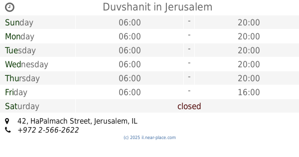
Duvshanit
HaPalmach Street 42, Jerusalem
Cafe
read more
947 m
מגדניה דובשנית
הפלמ"ח 42, ירושלים
Cafe
read more
963 m
Rachel Ba-Sdera
13, Sderot Ben Maimon, Jerusalem
Cafe
read more
964 m
Tomer's bread
Azza Street 30, Jerusalem
Bakery
Cafe
Food
Point of interest
Store
Establishment
read more
973 m
Арома
סינמה סיטי ירושלים, שדרות יצחק רבין 10, ירושלים
Cafe
read more
973 m
ארומה - סינמה סיטי
סינמה סיטי ירושלים, שדרות יצחק רבין 10, ירושלים
Cafe
read more
973 m
Aroma Espresso Bar ארומה אספרסו בר
סינמה סיטי ירושלים, שדרות יצחק רבין 10, ירושלים
Cafe
Food
Point of interest
Store
Establishment
read more
989 m
Cafe Greg
Sderot Yitshak Rabin 10, Jerusalem
Cafe
read more
1.051 km
Pinukit
Mordehai Narkis Street 6, Jerusalem
Cafe
read more
1.051 km
פינוקית
מרדכי נרקיס 8, ירושלים
Cafe
read more
1.051 km
פינוקית
מרדכי נרקיס 6, ירושלים
Cafe
read more
1.204 km
קפה בצלאל
בצלאל 8, ירושלים
Cafe
read more
1.204 km
Кафе Бецалель
Betsal'el Street 8, Jerusalem
Cafe
read more
📑
all categories
Accounting
Administrative area level 1
Administrative area level 2
Airport
Amusement park
Aquarium
Art gallery
Atm
Bakery
Bank
Bar
Beauty salon
Bicycle store
Book store
Bowling alley
Bus station
Cafe
Campground
Car dealer
Car rental
Car repair
Car wash
Casino
Cemetery
Church
City hall
Clothing store
Colloquial area
Convenience store
Country
Courthouse
Dentist
Department store
Doctor
Electrician
Electronics store
Embassy
Establishment
Finance
Fire station
Florist
Food
Funeral home
Furniture store
Gas station
General contractor
Grocery or supermarket
Gym
Hair care
Hardware store
Health
Hindu Temple
Home goods store
Hospital
Insurance agency
Intersection
Jewelry store
Laundry
Lawyer
Library
Light rail station
Liquor store
Local government office
Locality
Locksmith
Lodging
Meal delivery
Meal takeaway
Mosque
Movie rental
Movie theater
Moving company
Museum
Natural feature
Neighborhood
Night club
Painter
Park
Parking
Pet store
Pharmacy
Physiotherapist
Place of worship
Plumber
Point of interest
Police
Political
Post office
Premise
Real estate agency
Restaurant
Roofing contractor
Route
Rv park, camping
School
Shoe store
Shopping mall
Spa
Stadium
Storage
Store
Subpremise
Subway station
Supermarket
Synagogue
Taxi stand
Train station
Transit station
Travel agency
University
Veterinary care
Zoo
administrative area level 3
administrative area level 4
sublocality level 1
↑