Cafe nearby קפה ברברה
Israel
Cafe nearby קפה ברברה
קפה ברברה
99, משעול הפרדסים, כפר ויתקין, השרון, IL ישראל
contacts phone
:
+972
Latitude:
32.3798762
, Longitude:
34.8815626
larger map & directions
read more
nearest Cafe
759 m
קפה בכפר
סמטת המרפאה 11-12, כפר ויתקין
Cafe
read more
759 m
קפה בכפר
Simtat HaMirpa'a 11-12, Kfar Vitkin
Cafe
read more
1.366 km
לנדוור
קניון M הדרך, כפר ויתקין
Cafe
read more
1.366 km
Landwer
קניון M הדרך, Kfar Vitkin
Cafe
read more
1.367 km
קפה ג'ו M הדרך
M, Ha-Derekh la-Yam, Kfar Vitkin
Cafe
read more
1.367 km
Joe Cafe
M, Ha-Derekh la-Yam, Kfar Vitkin
Cafe
read more
1.447 km
Bakery Express
Israel
Cafe
read more
1.447 km
בייקרי אקספרס
Israel
Cafe
read more
1.462 km
Aroma
פז חופית ויתקין, בית ינאי
Cafe
read more
2.008 km
Copana
Derech Hailanot 7, Bitan Aharon
Cafe
read more
2.569 km
Green Cafe - גרין קפה חבצלת
תחנת דלק סונול, כביש 2, חבצלת השרון
Cafe
read more
3.173 km
אגדת לחם
הרב ישראלי 1, כפר הרא"ה
Cafe
read more
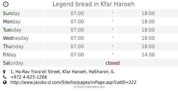
3.173 km
Legend bread
Ha-Rav Yisra'eli Street 1, Kfar Haroeh
Cafe
read more
3.375 km
סגפרדו אספרסו בר
משמר השרון
Cafe
read more
3.406 km
Baristafe
Ha-Migdal Street, Kfar Haim
Cafe
read more
3.475 km
העוגות של שושנה
Shivtei Israel Street, Kfar Haroeh
Cafe
read more
3.479 km
אלמגרו - Almagro
הראשונים 21, חיבת ציון
Cafe
read more
3.479 km
אלמגרו - Almagro
HaRishonim Street 21, Hibat Tzion
Cafe
read more
3.482 km
אלמגרו בית קפה (Almagro)
הראשונים 21, חיבת ציון
Cafe
read more
3.492 km
אלמגרו - Almagro
Hibat Tzion
Cafe
read more
3.492 km
אלמגרו - Almagro
חיבת ציון
Cafe
read more
3.958 km
עגלת הקפה
S'ar ha-, Sha'ar ha-Kfar Street 94, Kfar Yedidia
Cafe
read more
4.202 km
Cafe Turqouise
-Sha'ar Israel, Beit Yitzhak-Sha'ar Hefer
Cafe
read more
4.952 km
קפה מצדה
המרכז, Ruppin Street, Beit Berl
Cafe
read more
5.482 km
כמו פה הקפה של עזרי Ezri’s cafe
Unnamed Road, Givat Haim
Cafe
Food
Point of interest
Establishment
read more
📑
all categories
Accounting
Administrative area level 1
Administrative area level 2
Airport
Amusement park
Aquarium
Art gallery
Atm
Bakery
Bank
Bar
Beauty salon
Bicycle store
Book store
Bowling alley
Bus station
Cafe
Campground
Car dealer
Car rental
Car repair
Car wash
Casino
Cemetery
Church
City hall
Clothing store
Colloquial area
Convenience store
Country
Courthouse
Dentist
Department store
Doctor
Electrician
Electronics store
Embassy
Establishment
Finance
Fire station
Florist
Food
Funeral home
Furniture store
Gas station
General contractor
Grocery or supermarket
Gym
Hair care
Hardware store
Health
Hindu Temple
Home goods store
Hospital
Insurance agency
Intersection
Jewelry store
Laundry
Lawyer
Library
Light rail station
Liquor store
Local government office
Locality
Locksmith
Lodging
Meal delivery
Meal takeaway
Mosque
Movie rental
Movie theater
Moving company
Museum
Natural feature
Neighborhood
Night club
Painter
Park
Parking
Pet store
Pharmacy
Physiotherapist
Place of worship
Plumber
Point of interest
Police
Political
Post office
Premise
Real estate agency
Restaurant
Roofing contractor
Route
Rv park, camping
School
Shoe store
Shopping mall
Spa
Stadium
Storage
Store
Subpremise
Subway station
Supermarket
Synagogue
Taxi stand
Train station
Transit station
Travel agency
University
Veterinary care
Zoo
administrative area level 3
administrative area level 4
sublocality level 1
↑