Cafe nearby מאפית שילת
Israel
Cafe nearby מאפית שילת
מאפית שילת
Sderot Weizman, Kiryat Yam, Haifa, IL Israel
contacts phone
:
+972
Latitude:
32.8507609
, Longitude:
35.070636
larger map & directions
read more
nearest Cafe
49 m
מאפית שלום אליכם
Sderot Weizman 16, Kiryat Yam
Cafe
Food
Point of interest
Establishment
read more
338 m
CUP CAKE
Lehi Street 2, Kiryat Yam
Cafe
Food
Point of interest
Establishment
read more
620 m
בית קפה בגירה
פנחס לבון 13, קרית ים
Cafe
read more
703 m
Restaurant Bagira
Pinkhas Lavon Street 13, Kiryat Yam
Cafe
Point of interest
Food
Establishment
read more
867 m
Cafe Cafe
Irus Street 1, Kiryat Yam
Cafe
read more
867 m
Кафе Кафе
Irus Street 1, Kiryat Yam
Cafe
read more
867 m
קפה קפה כשר קרית ים
אירוס 1, קרית ים
Cafe
read more
889 m
Кофикс
Sderot Moshe Sharet 4, Kiryat Yam
Cafe
read more
889 m
cofix
שדרות משה שרת 4, קרית ים
Cafe
read more
938 m
עידן הקפה
מרטין בובר 1, קרית ים
Cafe
read more
938 m
עדן קפה
Martin Buber Street 1, Kiryat Yam
Cafe
read more
938 m
עידן הקפה
Martin Buber Street 1, Kiryat Yam
Cafe
read more
939 m
עדן קפה
קרית ים, Kiryat Tiv'on
Cafe
read more
1.113 km
אוהלי קפה | Tents Of Mercy Coffee
לכיש 41, קרית ים
Cafe
read more
1.125 km
קפה בחורש
79, HaHashmona'im Street, Kiryat Motzkin
Cafe
read more
1.52 km
COFIX
שדרות בן גוריון 82, קרית מוצקין
Cafe
read more
1.797 km
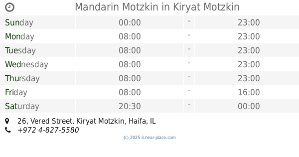
Mandarin Motzkin
Vered Street 26, Kiryat Motzkin
Cafe
read more
1.909 km
Wallstreet Cafe
שדרות בן גוריון 71, קרית מוצקין
Cafe
read more
1.973 km
Cafe Café
דרך עכו 192, קריית ביאליק
Cafe
read more
1.973 km
Cafe Café
Akko Road 192, Kiryat Bialik
Cafe
Store
Restaurant
Food
Point of interest
Establishment
read more
2.05 km
Gato - The cheesecake factory
Kiryat Bialik
Cafe
read more
2.05 km
Gato - The cheesecake factory
קריית ביאליק
Cafe
read more
2.103 km
Crema Cafe
Akko Road 192, Kiryat Bialik
Cafe
read more
2.142 km
רנה מוצקין - קנלו KANELO
מתחם מגה אור, קרית מוצקין
Cafe
read more
2.453 km
מועדון תזונה בריה
Kiryat Bialik
Cafe
Food
Point of interest
Establishment
read more
📑
all categories
Accounting
Administrative area level 1
Administrative area level 2
Airport
Amusement park
Aquarium
Art gallery
Atm
Bakery
Bank
Bar
Beauty salon
Bicycle store
Book store
Bowling alley
Bus station
Cafe
Campground
Car dealer
Car rental
Car repair
Car wash
Casino
Cemetery
Church
City hall
Clothing store
Colloquial area
Convenience store
Country
Courthouse
Dentist
Department store
Doctor
Electrician
Electronics store
Embassy
Establishment
Finance
Fire station
Florist
Food
Funeral home
Furniture store
Gas station
General contractor
Grocery or supermarket
Gym
Hair care
Hardware store
Health
Hindu Temple
Home goods store
Hospital
Insurance agency
Intersection
Jewelry store
Laundry
Lawyer
Library
Light rail station
Liquor store
Local government office
Locality
Locksmith
Lodging
Meal delivery
Meal takeaway
Mosque
Movie rental
Movie theater
Moving company
Museum
Natural feature
Neighborhood
Night club
Painter
Park
Parking
Pet store
Pharmacy
Physiotherapist
Place of worship
Plumber
Point of interest
Police
Political
Post office
Premise
Real estate agency
Restaurant
Roofing contractor
Route
Rv park, camping
School
Shoe store
Shopping mall
Spa
Stadium
Storage
Store
Subpremise
Subway station
Supermarket
Synagogue
Taxi stand
Train station
Transit station
Travel agency
University
Veterinary care
Zoo
administrative area level 3
administrative area level 4
sublocality level 1
↑