Cafe nearby מעדניה
Israel
Cafe nearby מעדניה
מעדניה
6, Levin Street, Petah Tikva, Petach Tikva, IL Израиль
contacts phone
:
+972 3-933-3141
Latitude:
32.0767438
, Longitude:
34.882376
larger map & directions
read more
nearest Cafe
351 m
רוטשילד 150
רוטשילד 150, פתח תקווה
Cafe
read more
384 m
נאור קפה ונרגילה
Gad Machnes Street 9, Petah Tikva
Cafe
read more
384 m
נאור קפה ונרגילה
9, Gad Machnes Street, Petah Tikva
Cafe
read more
553 m
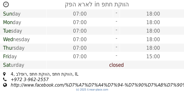
קפה אראל
בלפור 4, פתח תקווה
Cafe
read more
553 m
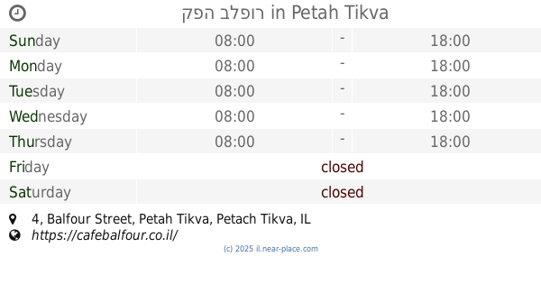
קפה בלפור
Balfour Street 4, Petah Tikva
Cafe
Food
Point of interest
Establishment
read more
760 m
קפה גנים
Lohamei HaGhetto Street 28, Petah Tikva
Cafe
read more
760 m
קפה גנים
לוחמי הגטו 28, פתח תקווה
Cafe
read more
957 m
קפה בוקה
פתח תקווה
Cafe
read more
957 m
Cafe Bouquet
Petah Tikva
Cafe
read more
1.152 km
Cafè Hillel
חיים עוזר פינת וולפסון 31, Petah Tikva
Cafe
read more
1.242 km
Кофикс
Hovevei Tsiyon Street 10, Petah Tikva
Cafe
read more
1.364 km
Кофикс
Khayim Ozer Street 12, Petah Tikva
Cafe
read more
1.388 km
קפה טוב
Aharon Katsir Street 3, Petah Tikva
Cafe
read more
1.454 km
cofizz
Baron Hirsch Street 9, Petah Tikva
Cafe
read more
1.929 km
FRESCO ITALIANO
פתח תקווה
Cafe
read more
1.965 km
קמחים בעמ
הכרמל 20, גני תקווה
Cafe
read more
1.981 km
קפה לנדוור
הכרמל 20, גני תקווה
Cafe
read more
2.354 km
Landwer Cafe
רח' זאב ז'בוטינסקי 72, פתח תקווה
Cafe
read more
2.389 km
Greg Cafe
דרך זאב ז'בוטינסקי 72, פתח תקווה
Cafe
read more
2.389 km
קפה ג'ו
דרך זאב ז'בוטינסקי 72, פתח תקווה
Cafe
read more
2.392 km
Roladin
הקניון הגדול פתח תקווה, רחוב זאב ז'בוטינסקי 72, פתח תקווה
Cafe
Food
Point of interest
Establishment
read more
2.394 km
Roladin
הקניון הגדול פתח תקווה, רח' זאב ז'בוטינסקי 72, פתח תקווה
Cafe
read more
2.405 km
cofix
Ze'ev Jabotinsky Street 72, Petah Tikva
Cafe
read more
2.405 km
קופיקס
רח' זאב ז'בוטינסקי 72, פתח תקווה
Cafe
read more
2.417 km
Арома
Ze'ev Jabotinsky Street 72, Petah Tikva
Cafe
read more
📑
all categories
Accounting
Administrative area level 1
Administrative area level 2
Airport
Amusement park
Aquarium
Art gallery
Atm
Bakery
Bank
Bar
Beauty salon
Bicycle store
Book store
Bowling alley
Bus station
Cafe
Campground
Car dealer
Car rental
Car repair
Car wash
Casino
Cemetery
Church
City hall
Clothing store
Colloquial area
Convenience store
Country
Courthouse
Dentist
Department store
Doctor
Electrician
Electronics store
Embassy
Establishment
Finance
Fire station
Florist
Food
Funeral home
Furniture store
Gas station
General contractor
Grocery or supermarket
Gym
Hair care
Hardware store
Health
Hindu Temple
Home goods store
Hospital
Insurance agency
Intersection
Jewelry store
Laundry
Lawyer
Library
Light rail station
Liquor store
Local government office
Locality
Locksmith
Lodging
Meal delivery
Meal takeaway
Mosque
Movie rental
Movie theater
Moving company
Museum
Natural feature
Neighborhood
Night club
Painter
Park
Parking
Pet store
Pharmacy
Physiotherapist
Place of worship
Plumber
Point of interest
Police
Political
Post office
Premise
Real estate agency
Restaurant
Roofing contractor
Route
Rv park, camping
School
Shoe store
Shopping mall
Spa
Stadium
Storage
Store
Subpremise
Subway station
Supermarket
Synagogue
Taxi stand
Train station
Transit station
Travel agency
University
Veterinary care
Zoo
administrative area level 3
administrative area level 4
sublocality level 1
↑