Cafe nearby Levinsky 41 Cafe
Coronavirus disease (COVID-19) Situation
confirmed cases
4841772
deaths
12707
Israel
Cafe nearby Levinsky 41 Cafe
Levinsky 41 Cafe
41, Levinsky, Tel Aviv-Yafo, IL Israel
contacts phone
:
+972 53-444-4557
website:
www.facebook.com
Latitude:
32.0598959
, Longitude:
34.7718238
larger map & directions
read more
nearest Cafe
22 m
קופיקס
לוינסקי 32, תל אביב יפו
Cafe
read more
23 m
Levinsky 41 Cafe
Levinsky 39, Tel Aviv-Yafo
Cafe
read more
302 m
אלבי
הגדוד העברי 8, תל אביב יפו
Cafe
read more
322 m
Кофикс
Lilienblum Street 21, Tel Aviv-Yafo
Cafe
read more
390 m
Rothschild8 Boutique Cafe
שדרות רוטשילד 8, תל אביב יפו
Cafe
read more
408 m
Убер
Barzilai Street 3, Tel Aviv-Yafo
Cafe
read more
490 m
Tali's Well Being
אחד העם 8, תל אביב יפו
Cafe
read more
526 m
Coffee Corner
Abarbanel Street 29, Tel Aviv-Yafo
Cafe
read more
546 m
לנדוור
שדרות רוטשילד 45, תל אביב יפו
Cafe
read more
559 m
בננה לוטי
נחלת בנימין 38, תל אביב יפו
Cafe
read more
574 m
CITIZEN GARDEN
15, Montefiore Street, Tel Aviv-Yafo
Cafe
read more
657 m
Harhare Cafe
102, Levinsky 90, Tel Aviv-Yafo
Cafe
read more
666 m
Golden sun Café kombucha bar גולדן סאן קפה בר קמבוצ'ה
אלנבי 87 Alenbi, תל אביב יפו
Cafe
read more
668 m
Landwer
רביעיית פלורנטין, אברבאנל 72, תל אביב יפו
Cafe
read more
729 m
Coffee Five
סלומון, תל אביב יפו
Cafe
read more
729 m
Café Noir
Ahad Ha'Am Street 43, Tel Aviv-Yafo
Cafe
read more
753 m
Albert Coffee Bar
Melchett Street 1, Tel Aviv-Yafo
Cafe
read more
810 m
באלי קפה
Levinsky 108, Tel Aviv-Yafo
Cafe
read more
845 m
Coffee Shop 51/ חמישים ואחד
אחד העם 51, תל אביב יפו
Cafe
read more
875 m
Cafe Lucia
Balfour Street 18, Tel Aviv-Yafo
Cafe
read more
895 m
Kolina
Maze Street 49, Tel Aviv-Yafo
Cafe
read more
971 m
Tuchka Bakery
ריב"ל 5, תל אביב יפו
Cafe
read more
1.008 km
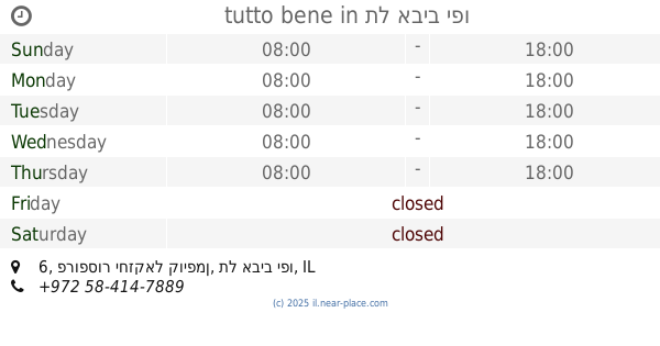
tutto bene
פרופסור יחזקאל קויפמן 6, תל אביב יפו
Cafe
read more
1.037 km
קפה לס
רבי מאיר 40, תל אביב יפו
Cafe
read more
1.08 km
רגע
שנקין 57, תל אביב יפו
Cafe
read more
📑
all categories
Accounting
Administrative area level 1
Administrative area level 2
Airport
Amusement park
Aquarium
Art gallery
Atm
Bakery
Bank
Bar
Beauty salon
Bicycle store
Book store
Bowling alley
Bus station
Cafe
Campground
Car dealer
Car rental
Car repair
Car wash
Casino
Cemetery
Church
City hall
Clothing store
Colloquial area
Convenience store
Country
Courthouse
Dentist
Department store
Doctor
Electrician
Electronics store
Embassy
Establishment
Finance
Fire station
Florist
Food
Funeral home
Furniture store
Gas station
General contractor
Grocery or supermarket
Gym
Hair care
Hardware store
Health
Hindu Temple
Home goods store
Hospital
Insurance agency
Intersection
Jewelry store
Laundry
Lawyer
Library
Light rail station
Liquor store
Local government office
Locality
Locksmith
Lodging
Meal delivery
Meal takeaway
Mosque
Movie rental
Movie theater
Moving company
Museum
Natural feature
Neighborhood
Night club
Painter
Park
Parking
Pet store
Pharmacy
Physiotherapist
Place of worship
Plumber
Point of interest
Police
Political
Post office
Premise
Real estate agency
Restaurant
Roofing contractor
Route
Rv park, camping
School
Shoe store
Shopping mall
Spa
Stadium
Storage
Store
Subpremise
Subway station
Supermarket
Synagogue
Taxi stand
Train station
Transit station
Travel agency
University
Veterinary care
Zoo
administrative area level 3
administrative area level 4
sublocality level 1
↑