Cafe nearby عجاوي كافيه
Israel
Cafe nearby عجاوي كافيه
عجاوي كافيه
Zababdeh
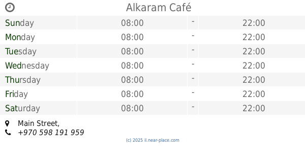
contacts phone
:
+972
Latitude:
32.3847799
, Longitude:
35.3240379
larger map & directions
read more
nearest Cafe
5.371 km
مقهى واستراحه الكينا
Jenin, Judida
Cafe
read more
7.445 km
Acro Café
Nablus Street, Jenin
Cafe
read more
7.986 km
Alkaram Café
Main Street
Cafe
read more
8.488 km
مقهى النباتات
شارع نابلس جنين
Cafe
read more
8.568 km
Cafe Algiers
شارع النباتات جنين
Cafe
read more
14.036 km
Picnic Tables Mt. Gilboa
6666, Rte 667 and, 6666
Cafe
read more
14.333 km
רותאנא קפה טבק ונרגילות
Gilboa Street, Nazareth Iliit
Cafe
read more
15.337 km
مقهى الفارس
Al Madrab
Cafe
read more
15.524 km
مقهى الشمال
مقهى الشمال -ديسكو
Cafe
read more
15.756 km
قهوة فايز سوالمه (Cafe)
المسبغة (وسط البلد, المصبغة الخضراء, Damascus
Cafe
read more
15.782 km
Coffe And Cake
asim sawalmeh
Cafe
read more
15.85 km
قهوة قتيبة (Cafe)
شارع مدرسة بنات عصيرة الاساسية
Cafe
read more
15.851 km
Cafe Abu Laith
عصيره الشماليه مقهى ابو ليث
Cafe
read more
16.25 km
قهوة أبو الرؤوف
C5W8+PWJ, Ya'bad
Cafe
Food
Point of interest
Establishment
read more
16.25 km
قهوة أبو الرؤوف
Ya'bad
Cafe
read more
19.538 km
חוויה בגלבוע
בת הגלבוע, גדעונה
Cafe
Park
Restaurant
Food
Store
Point of interest
Establishment
read more
19.694 km
קפה 71
7107, Tel Yosef
Cafe
read more
20.843 km
פרישייק
קריית ביאליק
Cafe
Food
Point of interest
Store
Establishment
read more
21.592 km
מאפה הבלקן
Umm al-Fahm
Cafe
Food
Point of interest
Store
Establishment
read more
22.083 km
בונז'ור סיטי
כביש ראשי, Umm al-Fahm
Cafe
Food
Point of interest
Establishment
read more
22.94 km
مقهى الكابتن
الخندق،, Umm al-Fahm
Cafe
Food
Point of interest
Establishment
read more
23.44 km
Cafe Cafe
Umm al-Fahm
Cafe
read more
24.525 km
Кафе Кафе
Joshua Hankin Street 14, Afula
Cafe
read more
24.631 km
נישנוש
קיבוץ, Merkhavya Street
Cafe
read more
24.78 km
Roladin
HaShuk Street 13, Afula
Cafe
read more
📑
all categories
Accounting
Administrative area level 1
Administrative area level 2
Airport
Amusement park
Aquarium
Art gallery
Atm
Bakery
Bank
Bar
Beauty salon
Bicycle store
Book store
Bowling alley
Bus station
Cafe
Campground
Car dealer
Car rental
Car repair
Car wash
Casino
Cemetery
Church
City hall
Clothing store
Colloquial area
Convenience store
Country
Courthouse
Dentist
Department store
Doctor
Electrician
Electronics store
Embassy
Establishment
Finance
Fire station
Florist
Food
Funeral home
Furniture store
Gas station
General contractor
Grocery or supermarket
Gym
Hair care
Hardware store
Health
Hindu Temple
Home goods store
Hospital
Insurance agency
Intersection
Jewelry store
Laundry
Lawyer
Library
Light rail station
Liquor store
Local government office
Locality
Locksmith
Lodging
Meal delivery
Meal takeaway
Mosque
Movie rental
Movie theater
Moving company
Museum
Natural feature
Neighborhood
Night club
Painter
Park
Parking
Pet store
Pharmacy
Physiotherapist
Place of worship
Plumber
Point of interest
Police
Political
Post office
Premise
Real estate agency
Restaurant
Roofing contractor
Route
Rv park, camping
School
Shoe store
Shopping mall
Spa
Stadium
Storage
Store
Subpremise
Subway station
Supermarket
Synagogue
Taxi stand
Train station
Transit station
Travel agency
University
Veterinary care
Zoo
administrative area level 3
administrative area level 4
sublocality level 1
↑