Cafe nearby הסטודיו של ג'יין
Israel
Cafe nearby הסטודיו של ג'יין
הסטודיו של ג'יין
Matzuva, Israel
contacts phone
:
+972
Latitude:
33.0646317
, Longitude:
35.1579716
larger map & directions
read more
nearest Cafe
3 km
בית קפה חנותא
חניתה
Cafe
read more
4.469 km
טראפלס - מגשי אירוח, בית קפה, קונדיטוריה, קייטרינג חלבי
48, Manot
Bakery
Cafe
Food
Point of interest
Store
Establishment
read more
4.959 km
cafe lekker בית קפה
Kabri
Cafe
read more
4.959 km
cafe lekker בית קפה
כברי
Cafe
read more
5.258 km
טוק טוקי
Israel
Cafe
read more
8.362 km
בית קפה טטילבאום
שד' הגעתון 35, Nahariya
Cafe
Food
Point of interest
Establishment
read more
8.529 km
Greg coffee Nahariya Arena
Nahariyya
Cafe
read more
8.681 km
Cofix
Sderot HaGa'aton 22, Nahariyya
Cafe
read more
8.683 km
Luckycoffee
Nahariyya
Cafe
Food
Point of interest
Establishment
read more
8.868 km
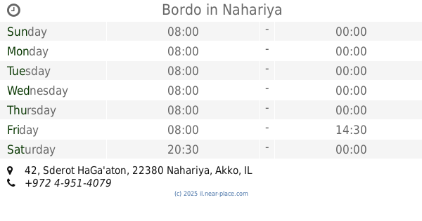
Bordo
Sderot HaGa'aton 42, Nahariyya
Cafe
read more
8.975 km
לנדוור
טיילת צפונית, נהריה
Cafe
read more
9.71 km
קורון פטיסרי
עברון
Cafe
read more
9.71 km
Couronne Patisserie
אין, Evron
Cafe
Food
Point of interest
Establishment
read more
10.842 km
קפאין עיוני בע״מ
מעונה
Cafe
read more
11.432 km
קקאו רגבה
מרכז BIG רגבה, רגבה
Cafe
read more
11.641 km
Knafe Pastry Place Jimmys
12, HaShuk Street 6, Ma'alot-Tarshiha
Cafe
read more
11.657 km
Cafe Sol
Ma'alot-Tarshiha
Cafe
read more
11.943 km
בית קפה ,בית מאפה
הכנסיות 2, מעלות תרשיחא
Cafe
read more
12.262 km
Cafe Maarag
Meron Street 270, Kfar Vradim
Cafe
read more
12.267 km
מרכז מארג
כפר ורדים
Cafe
read more
12.769 km
Beit Maafe maalot
Jabotinsky Street, Ma'alot-Tarshiha
Cafe
read more
13.403 km
Cafe Oliver
מרכז מסחרי כפר ורדים, כפר ורדים
Cafe
read more
16.107 km
מירוץ הקארטינג וקפיטריה
כביש 8544, דיר אל-אסד
Cafe
read more
17.069 km
Coffee Rzaz
Ha-Hagana Street 30, Acre
Cafe
read more
17.533 km
حلويات السلطان קונדיטוריה
Kisra-Sumei
Cafe
read more
📑
all categories
Accounting
Administrative area level 1
Administrative area level 2
Airport
Amusement park
Aquarium
Art gallery
Atm
Bakery
Bank
Bar
Beauty salon
Bicycle store
Book store
Bowling alley
Bus station
Cafe
Campground
Car dealer
Car rental
Car repair
Car wash
Casino
Cemetery
Church
City hall
Clothing store
Colloquial area
Convenience store
Country
Courthouse
Dentist
Department store
Doctor
Electrician
Electronics store
Embassy
Establishment
Finance
Fire station
Florist
Food
Funeral home
Furniture store
Gas station
General contractor
Grocery or supermarket
Gym
Hair care
Hardware store
Health
Hindu Temple
Home goods store
Hospital
Insurance agency
Intersection
Jewelry store
Laundry
Lawyer
Library
Light rail station
Liquor store
Local government office
Locality
Locksmith
Lodging
Meal delivery
Meal takeaway
Mosque
Movie rental
Movie theater
Moving company
Museum
Natural feature
Neighborhood
Night club
Painter
Park
Parking
Pet store
Pharmacy
Physiotherapist
Place of worship
Plumber
Point of interest
Police
Political
Post office
Premise
Real estate agency
Restaurant
Roofing contractor
Route
Rv park, camping
School
Shoe store
Shopping mall
Spa
Stadium
Storage
Store
Subpremise
Subway station
Supermarket
Synagogue
Taxi stand
Train station
Transit station
Travel agency
University
Veterinary care
Zoo
administrative area level 3
administrative area level 4
sublocality level 1
↑