Cafe nearby הקליניקה
Israel
Cafe nearby הקליניקה
הקליניקה
Beit Elazari, Israel
contacts phone
:
+972
Latitude:
31.8448854
, Longitude:
34.8007798
larger map & directions
read more
nearest Cafe
908 m
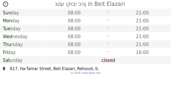
Neta Kobi Cohen
Ha-Tamar Street 617, Beit Elazari
Cafe
read more
908 m
נטע קובי כהן
התמר 617, בית אלעזרי
Cafe
read more
908 m
נטע וקובי כהן
Ha-Tamar Street 617, Beit Elazari
Cafe
Point of interest
Food
Establishment
read more
2.045 km
The Tituf House
Givat Brenner
Cafe
Food
Point of interest
Establishment
read more
2.497 km
Leonardo
Bilu center, Kiryat Ekron
Cafe
read more
2.599 km
פרש קיטשן
Israel
Cafe
read more
2.611 km
גרג קפה
בילו סנטר, רחובות
Cafe
read more
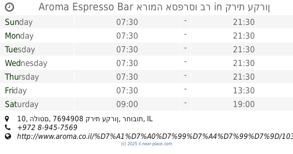
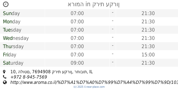
2.627 km
ארומה
בילו סנטר, הלוטם 10, קרית עקרון
Cafe
read more
2.627 km
Aroma Espresso Bar ארומה אספרסו בר
בילו סנטר, הלוטם 10, קרית עקרון
Cafe
Restaurant
Food
Point of interest
Store
Establishment
read more
3.126 km
דודי'ס סנביץ בר וקפה
בוריס פסטרנק 1, ראשון לציון
Cafe
read more
3.281 km
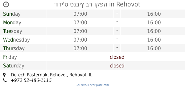
דודי'ס סנביץ בר וקפה
Derech Pasternak, Rehovot
Cafe
Food
Point of interest
Establishment
read more
4.07 km
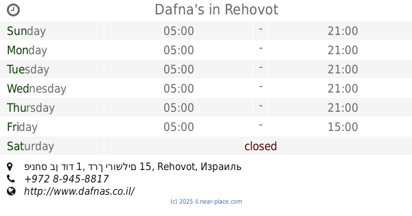
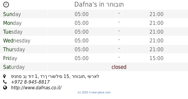
Dafna's
פינחס בן דוד 1, דרך ירושלים 15, Rehovot
Cafe
read more
4.07 km
Dafna's
פינחס בן דוד 1, דרך ירושלים 15, רחובות
Cafe
read more
4.21 km
נועם קפה ונרגילה
Nathan Alterman Street 24, Rehovot
Cafe
Food
Point of interest
Establishment
read more
4.212 km
קפה תושיה
Ha-Biluyim Street, Gedera
Cafe
read more
4.262 km
ארומה
פינס 14-24, גדרה
Cafe
read more
4.275 km
Кофикс
Ha-Biluyim Street 14, Gedera
Cafe
read more
4.275 km
Cofix Gedera
Ha-Biluyim Street 14, Gedera
Cafe
read more
4.299 km
Кафе Кафе
הבילויים 5, גדרה
Cafe
read more
4.299 km
קפה קפה
הבילויים 5, גדרה
Cafe
read more
4.315 km
Roladin
Herzl Street 10, Gedera
Cafe
read more
4.795 km
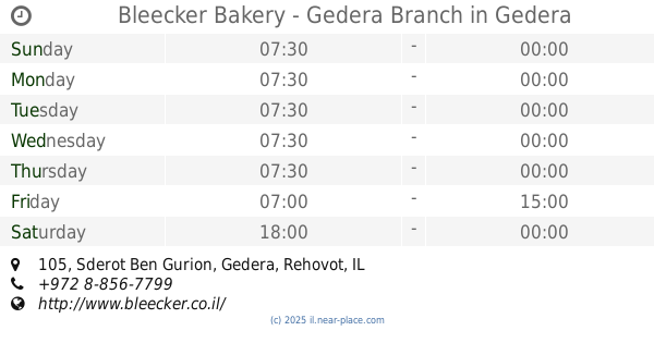
Bleecker Bakery - Gedera Branch
Sderot Ben Gurion 105, Gedera
Cafe
read more
5.046 km
מנחת עדן
הרב זכריה מדאר 20, רחובות
Cafe
read more
5.046 km
מנחת עדן
Ha-Rav Zekharya Madar Street 20, Rehovot
Cafe
read more
5.188 km
מזנון התעשיה
Yetsira Street 2, Rehovot
Cafe
Food
Point of interest
Establishment
read more
📑
all categories
Accounting
Administrative area level 1
Administrative area level 2
Airport
Amusement park
Aquarium
Art gallery
Atm
Bakery
Bank
Bar
Beauty salon
Bicycle store
Book store
Bowling alley
Bus station
Cafe
Campground
Car dealer
Car rental
Car repair
Car wash
Casino
Cemetery
Church
City hall
Clothing store
Colloquial area
Convenience store
Country
Courthouse
Dentist
Department store
Doctor
Electrician
Electronics store
Embassy
Establishment
Finance
Fire station
Florist
Food
Funeral home
Furniture store
Gas station
General contractor
Grocery or supermarket
Gym
Hair care
Hardware store
Health
Hindu Temple
Home goods store
Hospital
Insurance agency
Intersection
Jewelry store
Laundry
Lawyer
Library
Light rail station
Liquor store
Local government office
Locality
Locksmith
Lodging
Meal delivery
Meal takeaway
Mosque
Movie rental
Movie theater
Moving company
Museum
Natural feature
Neighborhood
Night club
Painter
Park
Parking
Pet store
Pharmacy
Physiotherapist
Place of worship
Plumber
Point of interest
Police
Political
Post office
Premise
Real estate agency
Restaurant
Roofing contractor
Route
Rv park, camping
School
Shoe store
Shopping mall
Spa
Stadium
Storage
Store
Subpremise
Subway station
Supermarket
Synagogue
Taxi stand
Train station
Transit station
Travel agency
University
Veterinary care
Zoo
administrative area level 3
administrative area level 4
sublocality level 1
↑