Cafe nearby Deft Sawars
Israel
Cafe nearby Deft Sawars
Deft Sawars
Bialik St 13, Ashdod, ישראל
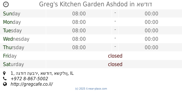
contacts phone
:
+972
Latitude:
31.7969266
, Longitude:
34.644674
larger map & directions
read more
nearest Cafe
282 m
Cafe Cafe קניון הזהב
Ashdod
Cafe
Food
Point of interest
Establishment
read more
315 m
ארומה קניון לב אשדוד
יהודה הלוי 14, אשדוד
Cafe
read more
337 m
ארומה לב אשדוד
Yehuda Halevi Street 7, Ashdod
Cafe
Food
Point of interest
Establishment
read more
400 m
קיוסק אנג'לה
Keren ha-Yesod Street 2, Ashdod
Cafe
Food
Point of interest
Establishment
read more
449 m
בל קפה איטליה
Yehuda Halevi Street 20, Ashdod
Cafe
Food
Point of interest
Establishment
read more
498 m
לה קאסה ארגנטינה
Ha-Shayatim Street 1/10, Ashdod
Cafe
Food
Point of interest
Establishment
read more
536 m
קפה מזל טוב
Ha-Atsma'ut Street 5, Ashdod
Cafe
Food
Point of interest
Store
Establishment
read more
593 m
Shalom Café
Haim Moshe Shapira Street 24, Ashdod
Cafe
Food
Point of interest
Store
Establishment
read more
593 m
קפה שלום
חיים משה שפירא 156, אשדוד
Cafe
read more
597 m
מרכז מסחרי
Rogozin Street 45, Ashdod
Cafe
Food
Point of interest
Establishment
read more
728 m
ארומה
See Mall, Ha-Gdud ha-Ivri St 6, אשדוד
Cafe
read more
752 m
BLECKER BAKERY
אשדוד
Cafe
read more
752 m
BLECKER BAKERY
Ashdod
Cafe
read more
791 m
רולדין אשדוד
הגדוד העברי, אשדוד
Cafe
read more
907 m
ליאון Lyon מתחם גן העיר
הגדוד העברי, אשדוד
Cafe
read more
907 m
Lyon
Ha-Gdud ha-Ivri Street, Ashdod
Cafe
read more
909 m
Greg's Kitchen Garden Ashdod
גן העיר, הגדוד העברי 1, אשדוד
Cafe
read more
922 m
קופיקס סיטי אשדוד
Ha-Atsma'ut Street 93, Ashdod
Cafe
read more
922 m
Кофикс
Ha-Atsma'ut Street 93, Ashdod
Cafe
read more
922 m
קופיקס סיטי אשדוד
העצמאות 93, אשדוד
Cafe
read more
922 m
cofix
Ha-Atsma'ut St 93, Ashdod
Cafe
read more
922 m
cofix
Ha-Atsma'ut Street 93, Ashdod
Cafe
read more
937 m
Coffee Shop - City
העצמאות 87, אשדוד
Cafe
read more
982 m
coffeat
Ha-Tsiyonut Street 8, Ashdod
Cafe
read more
1.076 km
בית קפה דוד
Ha-Rav Herzog Street 7, Ashdod
Cafe
Food
Point of interest
Establishment
read more
📑
all categories
Accounting
Administrative area level 1
Administrative area level 2
Airport
Amusement park
Aquarium
Art gallery
Atm
Bakery
Bank
Bar
Beauty salon
Bicycle store
Book store
Bowling alley
Bus station
Cafe
Campground
Car dealer
Car rental
Car repair
Car wash
Casino
Cemetery
Church
City hall
Clothing store
Colloquial area
Convenience store
Country
Courthouse
Dentist
Department store
Doctor
Electrician
Electronics store
Embassy
Establishment
Finance
Fire station
Florist
Food
Funeral home
Furniture store
Gas station
General contractor
Grocery or supermarket
Gym
Hair care
Hardware store
Health
Hindu Temple
Home goods store
Hospital
Insurance agency
Intersection
Jewelry store
Laundry
Lawyer
Library
Light rail station
Liquor store
Local government office
Locality
Locksmith
Lodging
Meal delivery
Meal takeaway
Mosque
Movie rental
Movie theater
Moving company
Museum
Natural feature
Neighborhood
Night club
Painter
Park
Parking
Pet store
Pharmacy
Physiotherapist
Place of worship
Plumber
Point of interest
Police
Political
Post office
Premise
Real estate agency
Restaurant
Roofing contractor
Route
Rv park, camping
School
Shoe store
Shopping mall
Spa
Stadium
Storage
Store
Subpremise
Subway station
Supermarket
Synagogue
Taxi stand
Train station
Transit station
Travel agency
University
Veterinary care
Zoo
administrative area level 3
administrative area level 4
sublocality level 1
↑