Cafe nearby בית עוגיות מרוקאיות בעמ
Israel
Cafe nearby בית עוגיות מרוקאיות בעמ
בית עוגיות מרוקאיות בעמ
27, יד חרוצים, נתניה, השרון, IL ישראל
contacts phone
:
+972 9-865-1615
website:
www.morcook.co.il
Latitude:
32.2832734
, Longitude:
34.8654021
larger map & directions
read more
nearest Cafe
130 m
ברדו
יד חרוצים 19, נתניה
Cafe
read more
130 m
ברדו
Yad Harutsim Street 19, Netanya
Cafe
read more
383 m
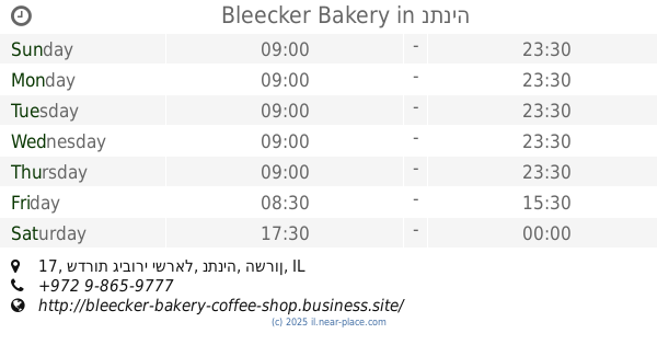
בליקר בייקרי
א.ת. פולג, שדרות גיבורי ישראל 17, נתניה
Cafe
read more
383 m
Bleecker Bakery
א.ת. פולג, שדרות גיבורי ישראל 17, נתניה
Cafe
read more
453 m
ארומה
גיבורי ישראל 17, יכין סנטר פולג, Netanya
Cafe
read more
453 m
Aroma
גיבורי ישראל 17, יכין סנטר פולג, Netanya
Cafe
read more
475 m
סיגרים | קפה | מוצרי טבק - COHENS
Ha-Melakha Street 43, Netanya
Cafe
read more
487 m
ברדו
הבונים 12, נתניה
Cafe
read more
688 m
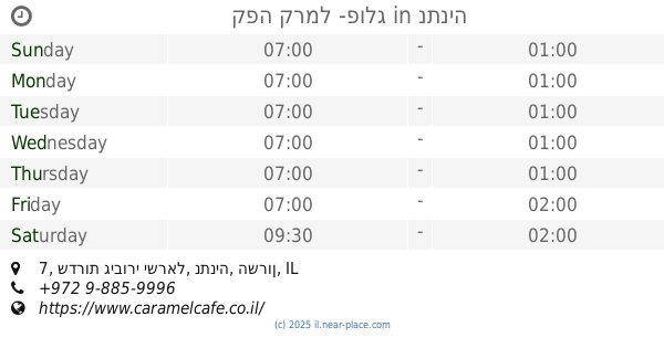
קפה קרמל -פולג
שדרות גיבורי ישראל 7, נתניה
Cafe
read more
811 m
קופיקס
Sderot Giborei Israel 12, Netanya
Cafe
read more
811 m
קופיקס
שדרות גיבורי ישראל 12, נתניה
Cafe
read more
811 m
cofix
Sderot Giborei Israel 12, Netanya
Cafe
read more
933 m
Bleecker Bakery
1, HaMehkar Street, Netanya
Cafe
read more
933 m
בליקר בייקרי
1, המחקר, נתניה
Cafe
read more
941 m
Arcaffe
אזור תעשיה פולג, בני גאון 10, נתניה
Cafe
read more
941 m
ארקפה
אזור תעשיה פולג, בני גאון 10, נתניה
Cafe
read more
1.003 km
Bleecker Bakery
HaMehkar Street 1, Netanya
Cafe
Food
Point of interest
Establishment
read more
1.011 km
קפה לנדוור
Netanya
Cafe
read more
1.011 km
קפה לנדוור
נתניה
Cafe
read more
1.012 km
קפה לנדוור
Maffi Street, Netanya
Cafe
read more
1.012 km
קפה לנדוור
מפי, נתניה
Cafe
read more
1.022 km
LILLI'S
Netanya
Cafe
read more
1.056 km
לנדוור
Maffi Street, Netanya
Cafe
read more
1.065 km
Lilli's French Patisserie
Maffi Street, Netanya
Cafe
read more
1.065 km
Lilli's French Patisserie
מפי, נתניה
Cafe
read more
📑
all categories
Accounting
Administrative area level 1
Administrative area level 2
Airport
Amusement park
Aquarium
Art gallery
Atm
Bakery
Bank
Bar
Beauty salon
Bicycle store
Book store
Bowling alley
Bus station
Cafe
Campground
Car dealer
Car rental
Car repair
Car wash
Casino
Cemetery
Church
City hall
Clothing store
Colloquial area
Convenience store
Country
Courthouse
Dentist
Department store
Doctor
Electrician
Electronics store
Embassy
Establishment
Finance
Fire station
Florist
Food
Funeral home
Furniture store
Gas station
General contractor
Grocery or supermarket
Gym
Hair care
Hardware store
Health
Hindu Temple
Home goods store
Hospital
Insurance agency
Intersection
Jewelry store
Laundry
Lawyer
Library
Light rail station
Liquor store
Local government office
Locality
Locksmith
Lodging
Meal delivery
Meal takeaway
Mosque
Movie rental
Movie theater
Moving company
Museum
Natural feature
Neighborhood
Night club
Painter
Park
Parking
Pet store
Pharmacy
Physiotherapist
Place of worship
Plumber
Point of interest
Police
Political
Post office
Premise
Real estate agency
Restaurant
Roofing contractor
Route
Rv park, camping
School
Shoe store
Shopping mall
Spa
Stadium
Storage
Store
Subpremise
Subway station
Supermarket
Synagogue
Taxi stand
Train station
Transit station
Travel agency
University
Veterinary care
Zoo
administrative area level 3
administrative area level 4
sublocality level 1
↑