Cafe nearby בראלי קפה
Israel
Cafe nearby בראלי קפה
בראלי קפה
10, ניסים אלוני, תל אביב יפו, IL ישראל
contacts phone
:
+972
Latitude:
32.089009
, Longitude:
34.7971753
larger map & directions
read more
nearest Cafe
422 m
Кафе Кафе
Derech Menachem Begin 11, Ramat Gan
Cafe
read more
500 m
רשת בתי הקפה אילן'ס
רמת גן
Cafe
read more
500 m
Ilan's
Ramat Gan
Cafe
read more
533 m
שמואל
פנקס 62, תל אביב יפו
Cafe
read more
533 m
שמואל
Pinkas Street 62, Tel Aviv-Yafo
Cafe
read more
536 m
Big Ben time cafe
Ha-Yetsira Street 22, Ramat Gan
Cafe
read more
642 m
Familia De Cafe
תובל 17, רמת גן
Cafe
read more
642 m
Familia De Cafe
Tuval Street 17, Ramat Gan
Cafe
read more
672 m
קפה בבלי
הרב הרצוג 24, תל אביב יפו
Cafe
read more
708 m
Cafe Vice-Alfredo.
Derech Menachem Begin 7, Ramat Gan
Cafe
read more
741 m
קפה מילאנו-בורסת היהלומים
תובל 21, רמת גן
Cafe
read more
741 m
קופי אקספרס
רח' זאב ז'בוטינסקי 1, רמת גן
Cafe
read more
754 m
קפה בוקה
40, Yehuda HaMaccabi Street, Tel Aviv-Yafo
Cafe
read more
769 m
תחנת קפה
Ze'ev Jabotinsky Street 1, Ramat Gan
Cafe
read more
787 m
Аркафе
בית הראל, מתחם הבורסה, דרך אבא הלל 3, רמת-גן
Cafe
read more
791 m
Roladin - Yehuda Maccabi
יהודה המכבי 57, תל אביב יפו
Cafe
read more
791 m
אספרסו בר
Yehuda HaMaccabi Street 59, Tel Aviv-Yafo
Cafe
read more
793 m
אספרסו בר יהודה המכבי
יהודה המכבי 57, תל אביב יפו
Cafe
read more
812 m
Ilan's Coffee
ז'בוטינסקי 2, רמת גן
Cafe
read more
830 m
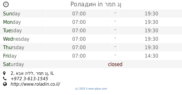
Роладин
אבא הילל 2, רמת גן
Cafe
read more
885 m
Cafe Cafe Hamedina Square
ה’ באייר 12, תל אביב יפו
Cafe
read more
945 m
פנקס הקטן
פנקס 31, תל אביב יפו
Cafe
read more
945 m
פנקס הקטן
Pinkas Street 31, Tel Aviv-Yafo
Cafe
read more
981 m
Bethlehem
Weizmann Street 20, Tel Aviv-Yafo
Bakery
Cafe
Food
Point of interest
Store
Establishment
read more
991 m
קפה של רבקה
שטריקר 46, תל אביב יפו
Cafe
read more
📑
all categories
Accounting
Administrative area level 1
Administrative area level 2
Airport
Amusement park
Aquarium
Art gallery
Atm
Bakery
Bank
Bar
Beauty salon
Bicycle store
Book store
Bowling alley
Bus station
Cafe
Campground
Car dealer
Car rental
Car repair
Car wash
Casino
Cemetery
Church
City hall
Clothing store
Colloquial area
Convenience store
Country
Courthouse
Dentist
Department store
Doctor
Electrician
Electronics store
Embassy
Establishment
Finance
Fire station
Florist
Food
Funeral home
Furniture store
Gas station
General contractor
Grocery or supermarket
Gym
Hair care
Hardware store
Health
Hindu Temple
Home goods store
Hospital
Insurance agency
Intersection
Jewelry store
Laundry
Lawyer
Library
Light rail station
Liquor store
Local government office
Locality
Locksmith
Lodging
Meal delivery
Meal takeaway
Mosque
Movie rental
Movie theater
Moving company
Museum
Natural feature
Neighborhood
Night club
Painter
Park
Parking
Pet store
Pharmacy
Physiotherapist
Place of worship
Plumber
Point of interest
Police
Political
Post office
Premise
Real estate agency
Restaurant
Roofing contractor
Route
Rv park, camping
School
Shoe store
Shopping mall
Spa
Stadium
Storage
Store
Subpremise
Subway station
Supermarket
Synagogue
Taxi stand
Train station
Transit station
Travel agency
University
Veterinary care
Zoo
administrative area level 3
administrative area level 4
sublocality level 1
↑