Cafe nearby Angel Bakery
Israel
Cafe nearby Angel Bakery
Angel Bakery
3, Sderot Golda Me'ir, Jerusalem, IL Israel
contacts phone
:
+972 2-537-1098
Latitude:
31.7970501
, Longitude:
35.2182287
larger map & directions
read more
nearest Cafe
מאפיית אנג'ל
שדרות גולדה מאיר 3, ירושלים
Cafe
read more
191 m
סניף קופיז בר אילן
שמואל הנביא 97, ירושלים
Cafe
read more
192 m
קופיז
שמואל הנביא 97, ירושלים
Cafe
read more
192 m
cofizz
Shmu'el ha-Navi Street 97, Jerusalem
Cafe
read more
192 m
cofizz
שמואל הנביא 97, ירושלים
Cafe
read more
311 m
סאטמער
,,ישראל, Eli ha-Cohen Street 27, Jerusalem
Cafe
read more
389 m
קאווע שטיבעל פון סאטמער מקווה
Even ha-Azel Street 26-28, Jerusalem
Cafe
read more
389 m
קאווע שטיבעל פון סאטמער מקווה
אבן האזל 26-28, ירושלים
Cafe
read more
773 m
מאפית פריש
Yekhezkel Street 18, Jerusalem
Cafe
read more
780 m
קפה מלכה
Hartom Street 9, Jerusalem
Cafe
read more
780 m
קפה מלכה
הרטום 9, ירושלים
Cafe
read more
781 m
Chaim Yona's Chill
Yosef Karo Street 25, Jerusalem
Cafe
read more
781 m
Chaim Yona's Chill
יוסף קארו 25, ירושלים
Cafe
read more
877 m
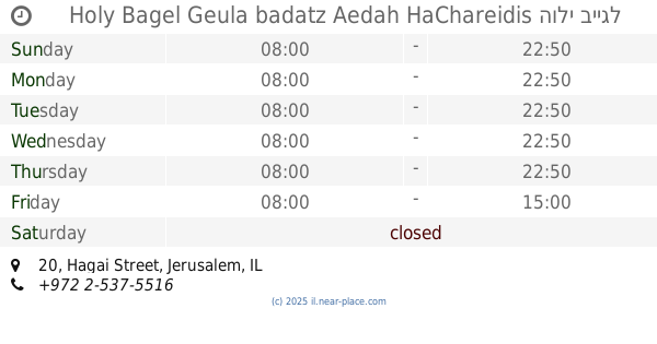
הולי בייגל
חגי 20, ירושלים
Cafe
read more
877 m
Holy Bagel Geula badatz Aedah HaChareidis הולי בייגל אנג׳ל גאולה העדה החרדית
Hagai Street 20, Jerusalem
Bakery
Meal takeaway
Cafe
Restaurant
Food
Point of interest
Store
Establishment
read more
924 m
מאפית גרליץ
Malkei Israel Street 35, Jerusalem
Cafe
read more
953 m
Neeman
מרכז מסחרי רמת אשכול, פארן 7, ירושלים
Cafe
read more
953 m
New York Bakeshop
Beit Yisra'el Street, Jerusalem
Cafe
read more
970 m
מוישיס מאפיה
שמגר 16, ירושלים
Cafe
read more
994 m
Waffle Bar Ramat Eshkol
فارن 7، القدس
Cafe
read more
994 m
וופל בר רמת אשכול - כשר - Waffle Bar Ramat Eshkol
פארן 7, ירושלים
Cafe
read more
994 m
וופל בר רמת אשכול - כשר - Waffle Bar Ramat Eshkol
فارن 7، القدس
Cafe
read more
994 m
Waffle Bar Ramat Eshkol - Kosher - Waffle Bar Ramat Eshkol
فارن 7، القدس
Cafe
read more
1.017 km
קופיקס מאה שערים
מאה שערים 15-21, ירושלים
Cafe
read more
1.017 km
Кофикс
Me'a She'arim Street 15-21, Jerusalem
Cafe
read more
📑
all categories
Accounting
Administrative area level 1
Administrative area level 2
Airport
Amusement park
Aquarium
Art gallery
Atm
Bakery
Bank
Bar
Beauty salon
Bicycle store
Book store
Bowling alley
Bus station
Cafe
Campground
Car dealer
Car rental
Car repair
Car wash
Casino
Cemetery
Church
City hall
Clothing store
Colloquial area
Convenience store
Country
Courthouse
Dentist
Department store
Doctor
Electrician
Electronics store
Embassy
Establishment
Finance
Fire station
Florist
Food
Funeral home
Furniture store
Gas station
General contractor
Grocery or supermarket
Gym
Hair care
Hardware store
Health
Hindu Temple
Home goods store
Hospital
Insurance agency
Intersection
Jewelry store
Laundry
Lawyer
Library
Light rail station
Liquor store
Local government office
Locality
Locksmith
Lodging
Meal delivery
Meal takeaway
Mosque
Movie rental
Movie theater
Moving company
Museum
Natural feature
Neighborhood
Night club
Painter
Park
Parking
Pet store
Pharmacy
Physiotherapist
Place of worship
Plumber
Point of interest
Police
Political
Post office
Premise
Real estate agency
Restaurant
Roofing contractor
Route
Rv park, camping
School
Shoe store
Shopping mall
Spa
Stadium
Storage
Store
Subpremise
Subway station
Supermarket
Synagogue
Taxi stand
Train station
Transit station
Travel agency
University
Veterinary care
Zoo
administrative area level 3
administrative area level 4
sublocality level 1
↑