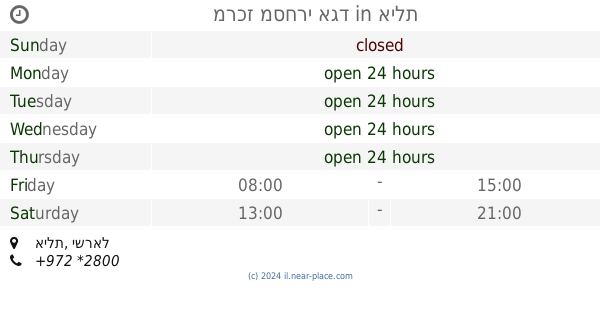
Bus station nearby בית חולים יוספטל
Coronavirus disease (COVID-19) Situation
confirmed cases
4841772
deaths
12707
Israel
Bus station nearby בית חולים יוספטל
בית חולים יוספטל
אילת, ישראל
contacts phone
:
+972
Latitude:
29.555451
, Longitude:
34.942169
larger map & directions
read more
nearest Bus station
239 m
ארגמן/דרך יותם
Israel
Bus station
read more
352 m
ששת הימים/דרך יותם
Israel
Bus station
read more
362 m
Argaman/HaNesher
Israel
Bus station
read more
413 m
ארגמן/חטיבת הנגב
Israel
Bus station
read more
510 m
אילות/לוס אנג'לס
Israel
Bus station
read more
544 m
ששת הימים/דרך הגיא
Israel
Bus station
read more
593 m
Hativat HaNegev/Kineret Alley
Israel
Bus station
read more
651 m
פארן/ירושלים השלמה
Israel
Bus station
read more
663 m
פארן/צין
Israel
Bus station
read more
685 m
Hativat HaNegev/Bet Hachayal
Israel
Bus station
read more
710 m
Hativat HaNegev/Barkan
Israel
Bus station
read more
731 m
Hativat HaNegev/Eilat Municipality
Israel
Bus station
read more
733 m
זהרון/מרכז עינת
Israel
Bus station
read more
803 m
הספורטאים/בית ספר בגין
Israel
Bus station
read more
806 m
מלכת שבא/הספורטאים
Israel
Bus station
read more
868 m
HaDuvdevan/Banana
Israel
Bus station
read more
874 m
Sheshet HaYamim/Ha'Agam
Israel
Bus station
read more
923 m
HaTmarim Boulevard/Ha'Almogim
Israel
Bus station
read more
929 m
Hahashmona'im/HaLevi'em
Israel
Bus station
read more
943 m
Roded/Gishron
Israel
Bus station
read more
974 m
Barne'a/Barak
Israel
Bus station
read more
997 m
Yerushalayim HaShlema/Shani
Israel
Bus station
read more
1.004 km
מרכז מסחרי אגד
אילת
Bus station
read more
1.086 km
Ha'Agam/Limon
Israel
Bus station
read more
1.097 km
הנבטים/המכבים
Israel
Bus station
read more
📑
all categories
Accounting
Administrative area level 1
Administrative area level 2
Airport
Amusement park
Aquarium
Art gallery
Atm
Bakery
Bank
Bar
Beauty salon
Bicycle store
Book store
Bowling alley
Bus station
Cafe
Campground
Car dealer
Car rental
Car repair
Car wash
Casino
Cemetery
Church
City hall
Clothing store
Colloquial area
Convenience store
Country
Courthouse
Dentist
Department store
Doctor
Electrician
Electronics store
Embassy
Establishment
Finance
Fire station
Florist
Food
Funeral home
Furniture store
Gas station
General contractor
Grocery or supermarket
Gym
Hair care
Hardware store
Health
Hindu Temple
Home goods store
Hospital
Insurance agency
Intersection
Jewelry store
Laundry
Lawyer
Library
Light rail station
Liquor store
Local government office
Locality
Locksmith
Lodging
Meal delivery
Meal takeaway
Mosque
Movie rental
Movie theater
Moving company
Museum
Natural feature
Neighborhood
Night club
Painter
Park
Parking
Pet store
Pharmacy
Physiotherapist
Place of worship
Plumber
Point of interest
Police
Political
Post office
Premise
Real estate agency
Restaurant
Roofing contractor
Route
Rv park, camping
School
Shoe store
Shopping mall
Spa
Stadium
Storage
Store
Subpremise
Subway station
Supermarket
Synagogue
Taxi stand
Train station
Transit station
Travel agency
University
Veterinary care
Zoo
administrative area level 3
administrative area level 4
sublocality level 1
↑