Bar nearby טאטי ביסטרו
Israel
Bar nearby טאטי ביסטרו
טאטי ביסטרו
53, HaShalom Road, Giv'atayim, IL Israel
contacts phone
:
+972 77-230-2594
website:
tatti-bistro.co.il
Latitude:
32.067164
, Longitude:
34.8031748
larger map & directions
read more
nearest Bar
369 m
HaShovach
Dam ha-Maccabim Street 26, Tel Aviv-Yafo
Restaurant
Bar
Food
Point of interest
Establishment
read more
546 m
MARLEN
Rambam Street 30, Giv'atayim
Bar
read more
930 m
Django Bar
Katzenelson Street 43, Giv'atayim
Bar
read more
976 m
Bogart RED
Katzenelson Street 50, Giv'atayim
Bar
read more
976 m
Neo After Dark
כצנלסון 55, גבעתיים
Bar
read more
976 m
Neo After Dark
Katzenelson Street 55, Giv'atayim
Bar
read more
989 m
Pergula Bar
Katzenelson Street 52, Giv'atayim
Bar
read more
1.017 km
שגית זין
יוסף זימן 2, תל אביב יפו
Bar
read more
1.017 km
פלייגראונד PlayGround
Katzenelson Street 59, Giv'atayim
Bar
read more
1.017 km
אוטו גבעתיים - OTTO GIVATAIM
Katzenelson Street 59, Giv'atayim
Bar
read more
1.017 km
שגית זין
Yosef Ziman Street 2, Tel Aviv-Yafo
Bar
read more
1.063 km
Zoot Allures
Katzenelson Street 67, Giv'atayim
Bar
read more
1.099 km
טיילר דרדן
הנגר 1, כפר סבא
Bar
read more
1.135 km
Chick
Nakhalat Yitskhak Street 1, Tel Aviv-Yafo
Bar
read more
1.135 km
Chick
נחלת יצחק 1, תל אביב יפו
Bar
read more
1.467 km
וויסקי בר מוזיאון
מתחם שרונה, רב אלוף דוד אלעזר 27, תל אביב יפו
Bar
read more
1.472 km
BEAKER BAR - ביקר בר
Katzenelson Street 110, Giv'atayim
Bar
read more
1.58 km
Beer Station
סירקין 12, גבעתיים
Bar
read more
1.615 km
Meetwine Sarona market
אלוף קלמן מגן 4, תל אביב יפו
Bar
read more
1.713 km
Frug & Co.
Arlozorov Street 29, Ramat Gan
Bar
read more
1.742 km
Hadar Dimal Hall
רח' זאב ז'בוטינסקי 1, רמת גן
Bar
read more
1.909 km
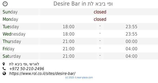
Desire Bar
תל אביב יפו
Bar
read more
1.938 km
Bar 911
שבח 11, תל אביב יפו
Bar
read more
1.938 km
Bar 911
Shevah Street 11, Tel Aviv-Yafo
Bar
read more
2.104 km
אנדרה מלך המיצים
50, Khanokh Street, Tel Aviv-Yafo
Bar
read more
📑
all categories
Accounting
Administrative area level 1
Administrative area level 2
Airport
Amusement park
Aquarium
Art gallery
Atm
Bakery
Bank
Bar
Beauty salon
Bicycle store
Book store
Bowling alley
Bus station
Cafe
Campground
Car dealer
Car rental
Car repair
Car wash
Casino
Cemetery
Church
City hall
Clothing store
Colloquial area
Convenience store
Country
Courthouse
Dentist
Department store
Doctor
Electrician
Electronics store
Embassy
Establishment
Finance
Fire station
Florist
Food
Funeral home
Furniture store
Gas station
General contractor
Grocery or supermarket
Gym
Hair care
Hardware store
Health
Hindu Temple
Home goods store
Hospital
Insurance agency
Intersection
Jewelry store
Laundry
Lawyer
Library
Light rail station
Liquor store
Local government office
Locality
Locksmith
Lodging
Meal delivery
Meal takeaway
Mosque
Movie rental
Movie theater
Moving company
Museum
Natural feature
Neighborhood
Night club
Painter
Park
Parking
Pet store
Pharmacy
Physiotherapist
Place of worship
Plumber
Point of interest
Police
Political
Post office
Premise
Real estate agency
Restaurant
Roofing contractor
Route
Rv park, camping
School
Shoe store
Shopping mall
Spa
Stadium
Storage
Store
Subpremise
Subway station
Supermarket
Synagogue
Taxi stand
Train station
Transit station
Travel agency
University
Veterinary care
Zoo
administrative area level 3
administrative area level 4
sublocality level 1
↑