Bar nearby פייק ניוז
Israel
Bar nearby פייק ניוז
פייק ניוז
8, HaArba'a Street, Tel Aviv-Yafo, IL Израиль
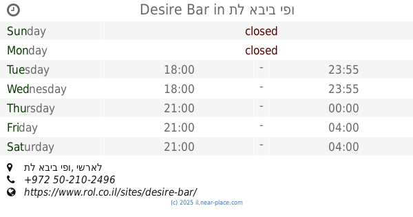
contacts phone
:
+972
Latitude:
32.0703454
, Longitude:
34.7834626
larger map & directions
read more
nearest Bar
107 m
מייקס פלייס
הארבעה 14, תל אביב יפו
Bar
read more
210 m
Desire Bar
תל אביב יפו
Bar
read more
323 m
בוננזה בר
שלמה אבן גבירול 17, תל אביב יפו
Bar
read more
352 m
Meetwine Sarona market
אלוף קלמן מגן 4, תל אביב יפו
Bar
read more
461 m
וויסקי בר מוזיאון
מתחם שרונה, רב אלוף דוד אלעזר 27, תל אביב יפו
Bar
read more
704 m
צ׳יקטי
יהודה הלוי פינת מזא"ה 58, תל-אביב יפו
Bar
read more
709 m
בר נאש
כיכר דיזנגוף 6, תל אביב יפו
Bar
read more
853 m
FIFTY
דיזנגוף 43, תל אביב יפו
Bar
read more
933 m
טפאלה
שלמה המלך 2, תל אביב יפו
Bar
read more
933 m
Library Bar
Nahmani Street 23-25, Tel Aviv-Yafo
Bar
read more
935 m
Silon
King George Street 89, Tel Aviv-Yafo
Bar
read more
960 m
Bar 911
Shevah Street 11, Tel Aviv-Yafo
Bar
read more
960 m
Bar 911
שבח 11, תל אביב יפו
Bar
read more
967 m
מיתוס גריל בר
מגדל אמות השקעות, וייצמן 2, תל אביב יפו
Bar
read more
983 m
קוקטייל ארט
החשמל 18 תל אביב
Bar
read more
1.029 km
Guest Room
מקווה ישראל 26, תל אביב יפו
Bar
read more
1.035 km
לואי
מלכי ישראל 4, תל אביב יפו
Bar
read more
1.037 km
Abraham Hostel Tel Aviv
לבונטין 21, תל אביב יפו
Bar
read more
1.129 km
Патрикс
רוטשילד 39, תל אביב - יפו
Bar
read more
1.153 km
Ariella's house-Bar
HaRakevet Street 2, Tel Aviv-Yafo
Bar
read more
1.211 km
BuXa
Rothschild Boulevard 31, Tel Aviv-Yafo
Bar
read more
1.211 km
BuXa
שדרות רוטשילד 31, תל אביב יפו
Bar
read more
1.272 km
May 6
13, Ben Ami Street, Tel Aviv-Yafo
Bar
read more
1.281 km
Спутник
Allenby Street 122, Tel Aviv-Yafo
Bar
read more
1.329 km
Shakeout Dizengoff
Dizengoff Street 95, Tel Aviv-Yafo
Bar
read more
📑
all categories
Accounting
Administrative area level 1
Administrative area level 2
Airport
Amusement park
Aquarium
Art gallery
Atm
Bakery
Bank
Bar
Beauty salon
Bicycle store
Book store
Bowling alley
Bus station
Cafe
Campground
Car dealer
Car rental
Car repair
Car wash
Casino
Cemetery
Church
City hall
Clothing store
Colloquial area
Convenience store
Country
Courthouse
Dentist
Department store
Doctor
Electrician
Electronics store
Embassy
Establishment
Finance
Fire station
Florist
Food
Funeral home
Furniture store
Gas station
General contractor
Grocery or supermarket
Gym
Hair care
Hardware store
Health
Hindu Temple
Home goods store
Hospital
Insurance agency
Intersection
Jewelry store
Laundry
Lawyer
Library
Light rail station
Liquor store
Local government office
Locality
Locksmith
Lodging
Meal delivery
Meal takeaway
Mosque
Movie rental
Movie theater
Moving company
Museum
Natural feature
Neighborhood
Night club
Painter
Park
Parking
Pet store
Pharmacy
Physiotherapist
Place of worship
Plumber
Point of interest
Police
Political
Post office
Premise
Real estate agency
Restaurant
Roofing contractor
Route
Rv park, camping
School
Shoe store
Shopping mall
Spa
Stadium
Storage
Store
Subpremise
Subway station
Supermarket
Synagogue
Taxi stand
Train station
Transit station
Travel agency
University
Veterinary care
Zoo
administrative area level 3
administrative area level 4
sublocality level 1
↑