Bar nearby Pharmacia- Cocktails & Bar
Israel
Bar nearby Pharmacia- Cocktails & Bar
Pharmacia- Cocktails & Bar
Sokolov Street 71, Ramat Hasharon Израиль
contacts phone
:
+972
Latitude:
32.1462975
, Longitude:
34.8385048
read more
nearest Bar
Pharmacia- Cocktails & Bar
סוקולוב 71, רמת השרון
Bar
read more
30 m
דבל'ה
Sokolov Street 71, Ramat Hasharon
Bar
read more
30 m
דבל'ה
סוקולוב 71, רמת השרון
Bar
read more
78 m
סוקו 77
סוקולוב 77, רמת השרון
Bar
read more
78 m
Soko 77
סוקולוב 77, Ramat Hasharon
Bar
read more
887 m
The basement
David Ben Gurion Street 32, Ramat Hasharon
Bar
read more
887 m
The basement
דוד בן גוריון 32, רמת השרון
Bar
read more
935 m
אסקימו לימון
אוסישקין 14, רמת השרון
Bar
read more
935 m
אסקימו לימון
Ussishkin Street 14, Ramat Hasharon
Bar
read more
1.822 km
דולי פרטון
שדרות בן גוריון 22, הרצליה
Bar
read more
1.822 km
Dolly Parton
Ben Gurion Boulevard 22, Herzliya
Bar
read more
1.835 km
רומר 22 RUMOR
בן גוריון 22, הרצליה
Bar
read more
1.835 km
Rumor 22
בן גוריון 22, Herzliya
Bar
read more
1.835 km
Rumor 22
Ben Gurion Boulevard 22, Herzliya
Bar
Restaurant
Food
Point of interest
Establishment
read more
2.292 km
Harsiada
Jabotinski Street 3, Herzliya
Bar
read more
2.292 km
Harsiada
ז'בוטינסקי 3, הרצליה
Bar
read more
2.43 km
Zakkay Mansion
מקס ברוד 11, תל אביב יפו
Bar
read more
2.43 km
Zakkay Mansion
Max Brod Street 11, Tel Aviv-Yafo
Bar
read more
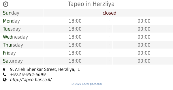
3.108 km
Tapeo - טפאו
Arieh Shenkar Street 9, Herzliya
Bar
read more
3.127 km
Tapeo
Arieh Shenkar Street 9, Herzliya
Bar
Restaurant
Food
Point of interest
Establishment
read more
3.212 km
גרגא פיטיץ׳ בר
Harash, או, Maskit Street 27, Herzliya
Bar
read more
3.225 km
SIX13 Lounge Bar
Hahoshlim Street 4, Herzliya
Bar
read more
3.255 km
בארניז
משכית 15, הרצליה
Bar
read more
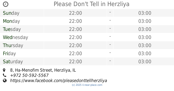
3.302 km
Please Don't Tell
Ha-Menofim Street 8, Herzliya
Bar
read more
3.406 km
Инга Бар
Galgalei ha-Plada Street 16, Herzliya
Bar
read more
📑
all categories
Accounting
Administrative area level 1
Administrative area level 2
Airport
Amusement park
Aquarium
Art gallery
Atm
Bakery
Bank
Bar
Beauty salon
Bicycle store
Book store
Bowling alley
Bus station
Cafe
Campground
Car dealer
Car rental
Car repair
Car wash
Casino
Cemetery
Church
City hall
Clothing store
Colloquial area
Convenience store
Country
Courthouse
Dentist
Department store
Doctor
Electrician
Electronics store
Embassy
Establishment
Finance
Fire station
Florist
Food
Funeral home
Furniture store
Gas station
General contractor
Grocery or supermarket
Gym
Hair care
Hardware store
Health
Hindu Temple
Home goods store
Hospital
Insurance agency
Intersection
Jewelry store
Laundry
Lawyer
Library
Light rail station
Liquor store
Local government office
Locality
Locksmith
Lodging
Meal delivery
Meal takeaway
Mosque
Movie rental
Movie theater
Moving company
Museum
Natural feature
Neighborhood
Night club
Painter
Park
Parking
Pet store
Pharmacy
Physiotherapist
Place of worship
Plumber
Point of interest
Police
Political
Post office
Premise
Real estate agency
Restaurant
Roofing contractor
Route
Rv park, camping
School
Shoe store
Shopping mall
Spa
Stadium
Storage
Store
Subpremise
Subway station
Supermarket
Synagogue
Taxi stand
Train station
Transit station
Travel agency
University
Veterinary care
Zoo
administrative area level 3
administrative area level 4
sublocality level 1
↑