Bar nearby Cellar Bar Jerusalem
Coronavirus disease (COVID-19) Situation
confirmed cases
4841772
deaths
12707
Israel
Bar nearby Cellar Bar Jerusalem
Cellar Bar Jerusalem
1, Louis Vincent Street, Jerusalem, IL Израиль
contacts phone
:
+972 2-627-9777
Latitude:
31.7895677
, Longitude:
35.2292079
larger map & directions
read more
nearest Bar
1.094 km
Piccadilly Pub
Heleni ha-Malka Street 9, Jerusalem
Bar
read more
1.094 km
פיקדילי בר
הלני המלכה 9, ירושלים
Bar
read more
1.108 km
בר 102
Jerusalem
Bar
read more
1.117 km
Addis Abba Bar
החבצלת 9, ירושלים
Bar
read more
1.117 km
Addis Abba Bar
HaHavatselet Street 9, Jerusalem
Bar
read more
1.126 km
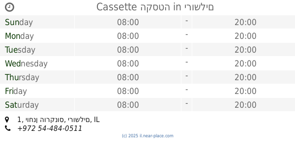
Cassette הקסטה
יוחנן הורקנוס 1, ירושלים
Bar
read more
1.179 km
דו נואס-Du Nuwas
Dhu Nuwas Street 4, Jerusalem
Bar
read more
1.18 km
בר הצעצוע
דו נואס 6, ירושלים
Bar
read more
1.217 km
חדר וחצי
Yafo Street 31, Jerusalem
Bar
read more
1.217 km
חדר וחצי
Jaffa Street 31, Jerusalem
Bar
read more
1.235 km
הפנינה השחורה
יפו 31, ירושלים
Bar
read more
1.235 km
הפנינה השחורה
Yafo Street, 31, Jerusalem
Bar
read more
1.238 km
גולה בר
יפו 31, ירושלים
Bar
read more
1.247 km
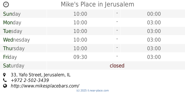
Mike's Place
Yafo Street 33, Jerusalem
Bar
read more
1.25 km
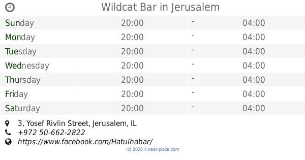
Wildcat Bar
Yosef Rivlin Street 3, Jerusalem
Bar
read more
1.252 km
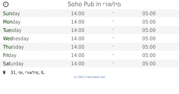
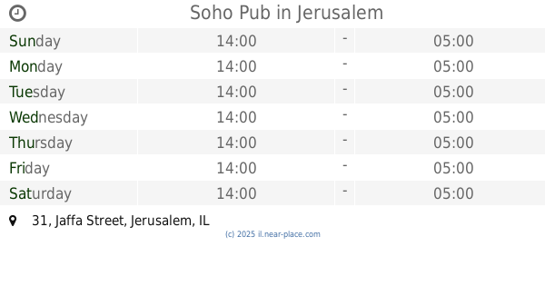
Soho Pub
יפו 31, ירושלים
Bar
read more
1.252 km
Soho Pub
Jaffa Street 31, Jerusalem
Bar
read more
1.255 km
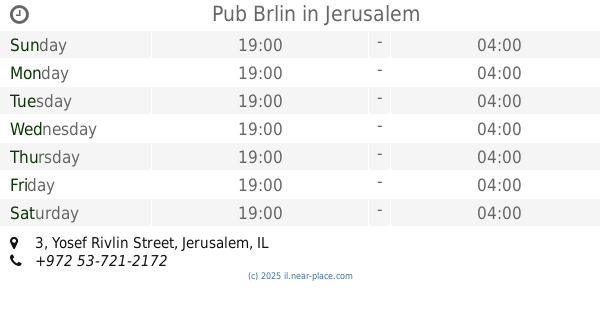
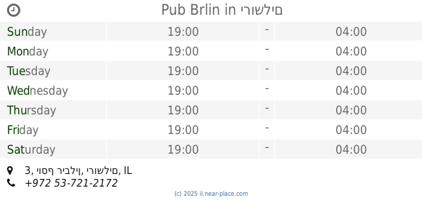
Pub Brlin
Yosef Rivlin Street 3, Jerusalem
Bar
read more
1.255 km
Pub Brlin
יוסף ריבלין 3, ירושלים
Bar
read more
1.268 km
פנקס הקטן
חצר פיינגולד, יוסף רבלין, ירושלים
Bar
read more
1.314 km
גואה נרגילות ובר
Yo'el Moshe Salomon Street 15, Jerusalem
Bar
read more
1.314 km
גואה בר
Yo'el Moshe Salomon Street 15, Jerusalem
Bar
read more
1.314 km
גואה בר
יואל משה סלומון 15, ירושלים
Bar
read more
1.354 km
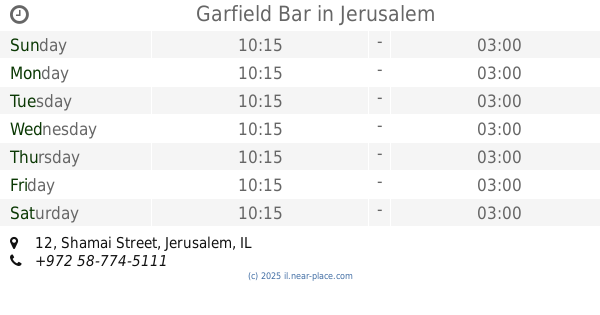
Garfield Bar
Shamai Street 12, Jerusalem
Bar
read more
1.365 km
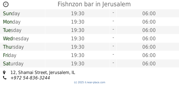
Fishnzon bar
Shamai Street 12, Jerusalem
Bar
read more
📑
all categories
Accounting
Administrative area level 1
Administrative area level 2
Airport
Amusement park
Aquarium
Art gallery
Atm
Bakery
Bank
Bar
Beauty salon
Bicycle store
Book store
Bowling alley
Bus station
Cafe
Campground
Car dealer
Car rental
Car repair
Car wash
Casino
Cemetery
Church
City hall
Clothing store
Colloquial area
Convenience store
Country
Courthouse
Dentist
Department store
Doctor
Electrician
Electronics store
Embassy
Establishment
Finance
Fire station
Florist
Food
Funeral home
Furniture store
Gas station
General contractor
Grocery or supermarket
Gym
Hair care
Hardware store
Health
Hindu Temple
Home goods store
Hospital
Insurance agency
Intersection
Jewelry store
Laundry
Lawyer
Library
Light rail station
Liquor store
Local government office
Locality
Locksmith
Lodging
Meal delivery
Meal takeaway
Mosque
Movie rental
Movie theater
Moving company
Museum
Natural feature
Neighborhood
Night club
Painter
Park
Parking
Pet store
Pharmacy
Physiotherapist
Place of worship
Plumber
Point of interest
Police
Political
Post office
Premise
Real estate agency
Restaurant
Roofing contractor
Route
Rv park, camping
School
Shoe store
Shopping mall
Spa
Stadium
Storage
Store
Subpremise
Subway station
Supermarket
Synagogue
Taxi stand
Train station
Transit station
Travel agency
University
Veterinary care
Zoo
administrative area level 3
administrative area level 4
sublocality level 1
↑